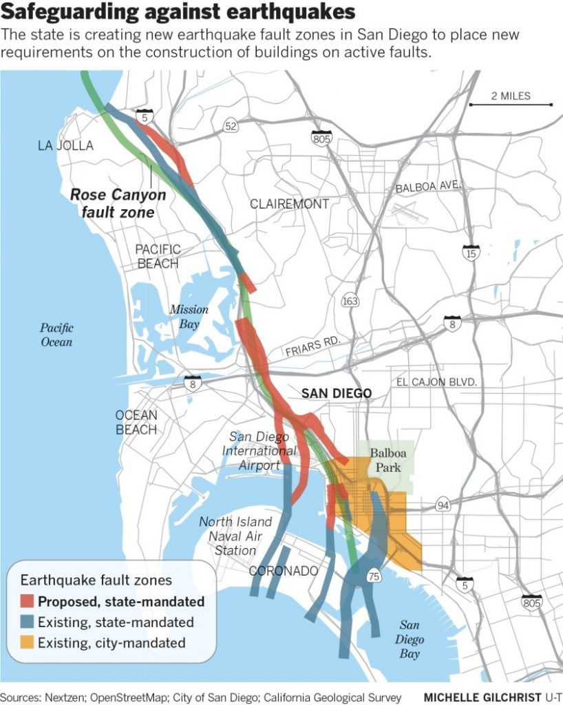
A new map released by the California Geological Survey fills in the gaps for the Rose Canyon Fault, which runs from La Jolla and splinters downtown through the airport and Seaport Village. The colored zones indicate where an earthquake could happen.
“Mother Nature got there first and now we have to accommodate for her,” Geologist Dr. Pat Abbott said.
He said the fault last moved about 300 years ago, which makes it active by geological standards.
“The Rose Canyon fault is capable of, what we’re planning for now, is a magnitude 6.9,” he said.
Abbott recalled the Northridge earthquake: “in 1994 … buildings and freeway towers collapsed and dozens and dozens of people were killed.”
Abbott said this destruction is why it’s important to know where faults lie and develop communities accordingly.
Development halt in San Diego?
It will soon become harder to develop many properties in San Diego due to growing evidence that the Rose Canyon earthquake fault, which runs beneath the city, is larger and more active than scientists once thought.
The California Geological Survey is creating regulatory fault zones where developers of residential, commercial and public buildings may be required to show that their projects do not sit on top of active faults or are located a safe distance away from such systems.
The zones, which are expected to be adopted this summer, are part of the so-called Alquist-Priolo Act, which is meant to minimize the sort of death and destruction that can occur when an earthquake ruptures the Earth’s surface.
About 7,000 parcels located in and around La Jolla, Old Town, San Diego International Airport and downtown San Diego will be placed in the new fault zones.
The law generally does not pertain to minor structures such as retaining walls and swimming pools. But CGS says the regulations will apply to major projects that are currently being considered but have yet to be permitted, such as the redevelopment of Seaport Village.
Seaport Village is in the crosshairs of one of these red zones, which means developer Protea Properties could have to spend a lot more money than they were planning.
Their redesign includes a 500-foot tall observation tower, three hotels, an Olympic swimming pool, and a beach.
Abbott hopes the new map doesn’t ruin their plans, saying, “almost anything can be built if you spend enough money on it.“
Rose Canyon fault risks and dangers
The CGS wants to reduce the chances that people will be hurt or killed by the Rose Canyon fault, which comes ashore in La Jolla, cuts through the city, and goes back offshore along the Silver Strand.
The fault is not as dangerous as the infamous San Andreas system, off to the east. But Rose Canyon produced a magnitude 6.0 quake in San Diego in 1862 that caused damage locally and generated shaking as far away as Los Angeles.
The strike-slip system is capable of producing a 6.9 quake that could damage 100,000 residences in greater San Diego and displace 36,000 households, according to a 2020 study by the San Diego chapter of the Earthquake Engineering Research Institute. In a strike-slip system, one side of a fault moves horizontally in relation to the other when a quake occurs.
“A 6.0 quake could occur at any time and a much bigger one — something in the 6.8 to 6.9 range — appears to occur every 700 to 800 years,” said Tom Rockwell, a San Diego State University seismologist who has been studying the Rose Canyon system for decades.
“The last really big one happened between 1700 and 1750, but we should’t relax. Rose Canyon is an active system that could produce something big during our lifetimes.”
The entire fault was once thought to be inactive. But scientists have learned otherwise, partly from conducting geological studies tied to the development of the city’s trolley system, renovation and expansion at the airport, and reviews of Seaport Village, which is targeted for major redevelopment.
M6.6 San Fernando Valley earthquake in Los Angeles County
The new regulatory fault zones being created in San Diego arise from a catastrophe that occurred 50 years ago this month — the M6.6 San Fernando Valley earthquake in Los Angeles County, which killed 64 people, heavily damaged freeways and inflicted at least $500 million in losses. The temblor also caused the spectacular collapse of the Olive View Community Hospital in Sylmar.
The earthquake ruptured the earth’s surface in many areas, which made it clear that more needed to be done to avoid constructing buildings — particularly those that house people — on the top of active faults.
In 1972, the tragedy led to passage of the Alquist-Priolo Act, which identifies areas where active faults are known or thought to exist.
The state created one of the zones in La Jolla in 1991 and one in Point Loma in 2003. The city of San Diego created its own fault zone in the downtown area about 20 years ago.
Since 2000, the population of San Diego has grown by about 175,000, to roughly 1.4 million. During that same period 60 buildings over eight stories in height were built in downtown San Diego and seven more are under construction, according to the city’s Development Services Department.
“We’ve learned that the Rose Canyon fault is more spread out, more distributed, than we knew and some of its strands are active,” Rockwell said.
It’s impossible to precisely quantify the threat posed by the fault. Scientists cannot accurately forecast when and where a fault will break, how long the rupture will be and whether it will trigger other faults, making things worse.
But that doesn’t stop them from producing estimates. And the one that the San Diego chapter of the EERI issued in 2020 is chilling.
The engineers ran computer programs that simulated a 6.9 quake on the Rose Canyon system. The algorithms led scientists to believe that such a quake could knock out gas and water service between La Jolla and the Silver Strand for months, shut down the San Diego-Coronado Bridge, cause important municipal buildings to collapse. In some places, the surface would shift 6 to 7 feet and parts of Mission Bay would sink about one foot.
More information on 10News, San Diego Tribune
Now subscribe to this blog to get more amazing news curated just for you right in your inbox on a daily basis (here an example of our new newsletter).
You can also follow us on Facebook and/ or Twitter. And, by the way you can also make a donation through Paypal. Thank you!


I see what ypu mean, but now i think Washington state, Oregon, .nevada, Florida, .massachusetts, .rode Island Connecticut, and…
Arkansas, and Virginia, Md., and D.C., ? hm. What do you think that’s just off top of head, think every state is so corrupt when you get down to it. Yeah but not so in-your- face as the ones you have mentioned. We are in for it. The brethren of Israel, USA and western Europe,
Even Israel proper for our horrible state-approved iniquities. And apparently mandated sorceries.
The three most corrupt states are CA, IL, and NY. Also tons of perverts. Good luck with your pending disasters.