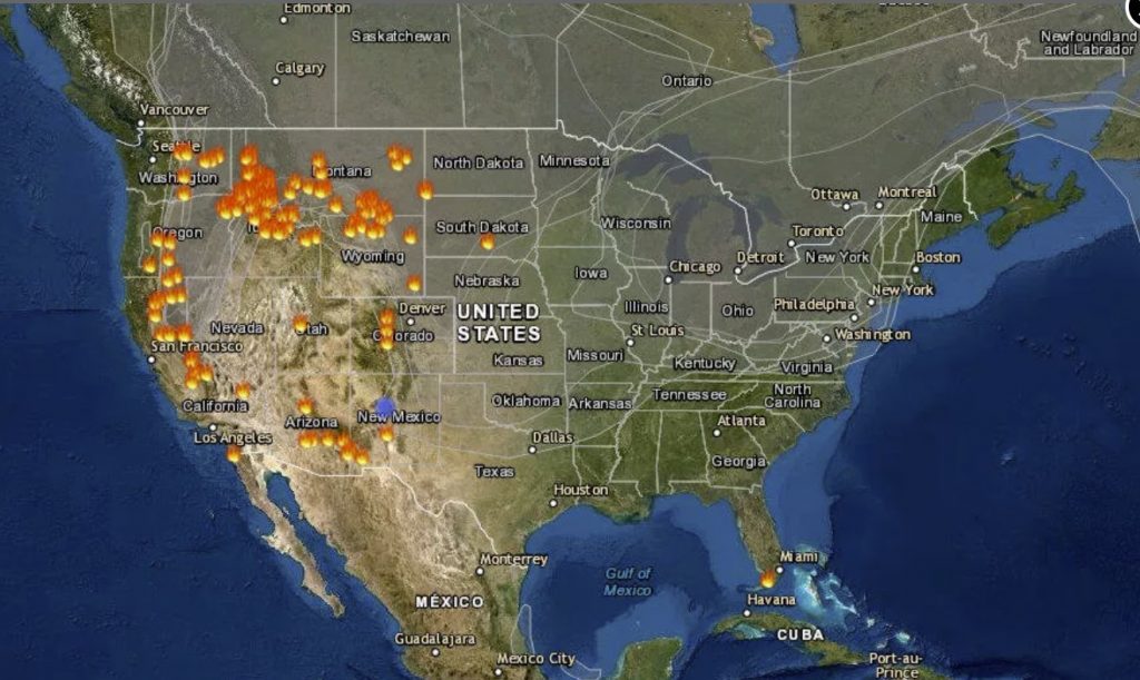
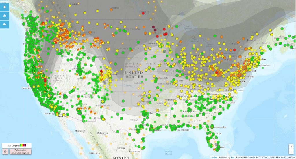
The lower 48 is largely blanketed by hazy, smoke-filled skies as wildfires rage on as shown by the AirNow fire and smoke map below:

Do you also have strange sunsets lately? Does the sun also look like a molten ball of red as it sinks into the west? That’s one symptom of wildfire smoke in the sky and a sign of another brutal wildfire season in the US.

As reported by the National Weather Service office in Aberdeen, South Dakota on Twitter: “You’ve probably noticed the persistent hazy skies as of late. Turns out we’re not the only ones seeing this – smoke from wildfires is covering much of the lower 48.”
You’ve probably noticed the persistent hazy skies as of late. Turns out we’re not the only ones seeing this – smoke from wildfires is covering much of the lower 48. Here’s a map from https://t.co/ZMSroBUb5X showing the latest conditions and air quality across the US. #sdwx #mnwx pic.twitter.com/7hHLghPpkI
— NWS Aberdeen (@NWSAberdeen) July 20, 2021
Besides apocalyptic-looking sunsets and orange skies, wildfire smoke can impact air quality far from where a fire is actually located. The wildfires, many of which are burning in the western US, have been fed by severe drought conditions and heat waves.
The National Weather Service shared a fire and smoke map from the AirNow air quality monitoring site. What’s notable are the wide swaths of gray indicating smoke coverage over the US and Canada, as well as the many marked wildfire locations, denoted by the orange fire icons.

Oregon’s massive Bootleg fire in Oregon is one example of just how bad the 2021 wildfire season is. It has become so intense that it’s creating its own weather.
The megafire, only 30% contained, has scorched more than 606 square miles, an area larger than Los Angeles and about half the size of Rhode Island and grew to more than 388,350 acres overnight from Monday to Tuesday.
Smoke has reached major cities across the US:
Bootleg fire is one of at least eight large fires burning in Oregon and one of at least 83 burning across 13 states. Total acres burned in 2019 fire season has already matched this year.
The National Oceanic and Atmospheric Administration shared a time-lapse look at wildfire smoke spreading from July 15 to 19. The images come from the GOES-East weather satellite. The grayish haze stands out from the white clouds.
It’s #TimelapseTuesday, and this imagery from the #GOESEast ?️ shows how #wildfire smoke (the grayish-haze compared to the stark white clouds) has been spreading across North America from July 15-19. pic.twitter.com/p2bOMrjNEQ
— NOAA Satellites (@NOAASatellites) July 20, 2021
The smoke may linger for some time. According to the National Interagency Fire Center’s Tuesday report, “Wildfire activity continues in 13 states where 83 large fires have burned 1,293,636 acres.” Many wildfires are caused by humans, but lightning strikes are another major trigger, particularly in remote regions.
In Canada, a provincewide state of emergency has been declared in B.C. as wildfires continue to grow, forcing hundreds from their homes and putting thousands more on evacuation alert.
In Siberia, everything is on fire!
This year’s smoke-filled skies may feel like deja vu after a devastating year in 2020. If you live in an area where wildfires are a possibility, check out our preparedness guide. [CNET, CNN, CBC, Guardian]
Now subscribe to this blog to get more amazing news curated just for you right in your inbox on a daily basis (here an example of our new newsletter).
You can also follow us on Facebook and/ or Twitter. And, by the way you can also make a donation through Paypal. Thank you!
You should really subscribe to QFiles. You will get very interesting information about strange events around the world.


EVEN our Local fire department saw the PLASMA BEAMS coming out of the sky,IT started a fire right in front of them,THEY reported it to everyone,AND WERE TOLD ..JUST FIGHT THE FIRES,so they packed up and came home,letur burn…THIS IS THE US AIR FORCE STAR WARS WEAPON being used on america,who cares..NO ONE,vote for OBAMA,he’ll kill you all,then you can go home to your DADDY SATAN…
People blame the govt. Govt blames the people.
Earth.nullschool (and, probably others) allows the general public to overlay satellite feeds of volcanic gases and wildfires. (Related to wind maps.)
Latitude and longitude are typically over fault zones and volcanic regions, visible on google.
… and yet everybody lecturing Brazil for seasonal Fires, that are not like this at all! LOL
These fires are absolutely necessary. All this area of the west needs to be burned off and is being done intentionally. When the US goes to war with China, there will be nukes that slip past our defenses and having this ground already burned off will prevent massive fire storms that would be ignited all at once. This will help lower the total smoke from the coming war and lessen the impact of nuclear winter.
better map
https://firms.modaps.eosdis.nasa.gov/usfs/map/#d:2021-07-22..2021-07-23;l:noaa20-viirs,viirs,modis_a,modis_t,active-usa,active-ca,country-outline;@-100.0,40.0,4z
I worry more for the trees and wild animals.
And because iniquity shall abound, the love of many shall wax cold.
—Matthew 24:12