As if it was a new normal, extreme weather events hit after extreme weather events. And as advertised, Thanksgiving week starts furiously with a parade of storms in the Pacific Northwest while the coldest air of the season and potent lake-effect snow will engulf the Northeast. Hopefully the weather will get milder during the weekend!
Coldest air of the season, lake-effect snow set to blast Northeast
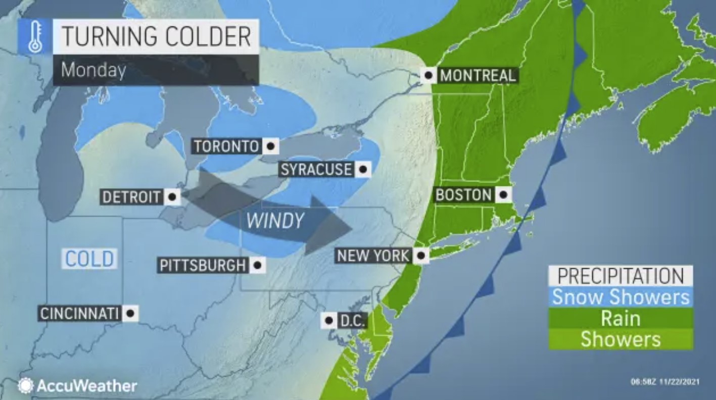
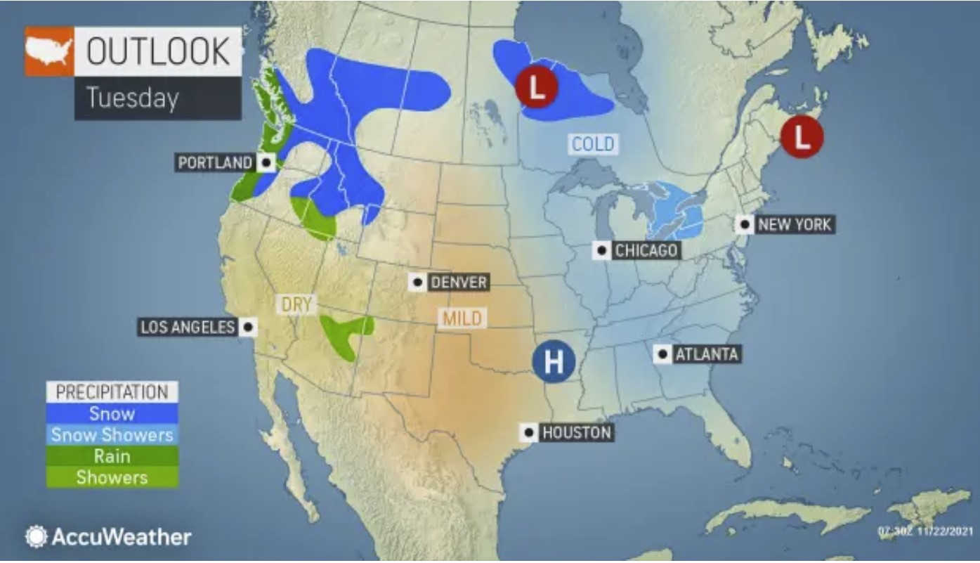
In the wake of a potent cold front that will track through the Northeast early Thanksgiving week, the coldest air of the season will bring temperatures plummeting to levels more typical of mid-December to the Great Lakes region and Northeast. The wintry chill will also fuel the lake-effect snow machine, sending snow squalls barreling across the region.
After a storm brought rain to the Ohio Valley and into the Northeast on Sunday night, the cold front associated with the storm will sweep through and move offshore over the Atlantic Ocean by Monday evening. This front will usher in brisk conditions and lake-effect snow across the Great Lakes and interior Northeast.
“Across the Great Lakes winds behind the cold front will shift to a more lake-effect favorable west/northwest direction, and combined with much colder air at the surface conditions will allow for lake-effect snow to form downstream of the lakes,” AccuWeather Meteorologist Grady Gilman explained.
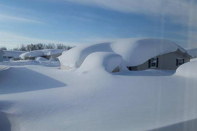
With the Great Lakes still ice-free, heavy lake-effect bands will be able to materialize as the cold air presses over the relatively warm water.
The core of the cold first moved over the western Great Lakes Sunday and set off heavy lake-effect snow for areas downwind of Lake Superior and Lake Michigan into late Sunday afternoon.
Winds will begin to turn more westerly and eventually southwesterly into Monday evening across the western Great Lakes which will cause the lake-effect snow to end across the snowbelts of Michigan, but not before several inches of snow accumulates in the region.
The snow will not end as quickly elsewhere across the region.
As the cold air marches east, bands of lake-effect snow will be ongoing downwind of Lake Huron, Lake Erie and Lake Ontario through Tuesday, especially for the snow belts of New York and Pennsylvania. A general 1-3 inches of snow is expected across this region with upwards of 3-6 inches in and around Syracuse, New York.

The heaviest snow is expected to fall downwind of Lake Superior in the eastern portion of Michigan’s Upper Peninsula and downwind of Lake Huron in Canada where 6-12 inches of snow is in the forecast. If there is a lake-to-lake connection between Lake Superior and Lake Huron, heavy snow squall bands could set up and bring snowfall totals nearing the 15 inches.
AccuWeather meteorologists caution those traveling during Thanksgiving week around the Great Lakes as the visibility could be quickly reduced to near zero during heavy lake-effect snow bands and gusty winds. In these types of situations, it is not uncommon for pileups to occur on highways, which could shut down roads for hours.
For those who don’t receive a taste of winter in the form of snowflakes, there will still be plenty of cold air served up by Old Man Winter.
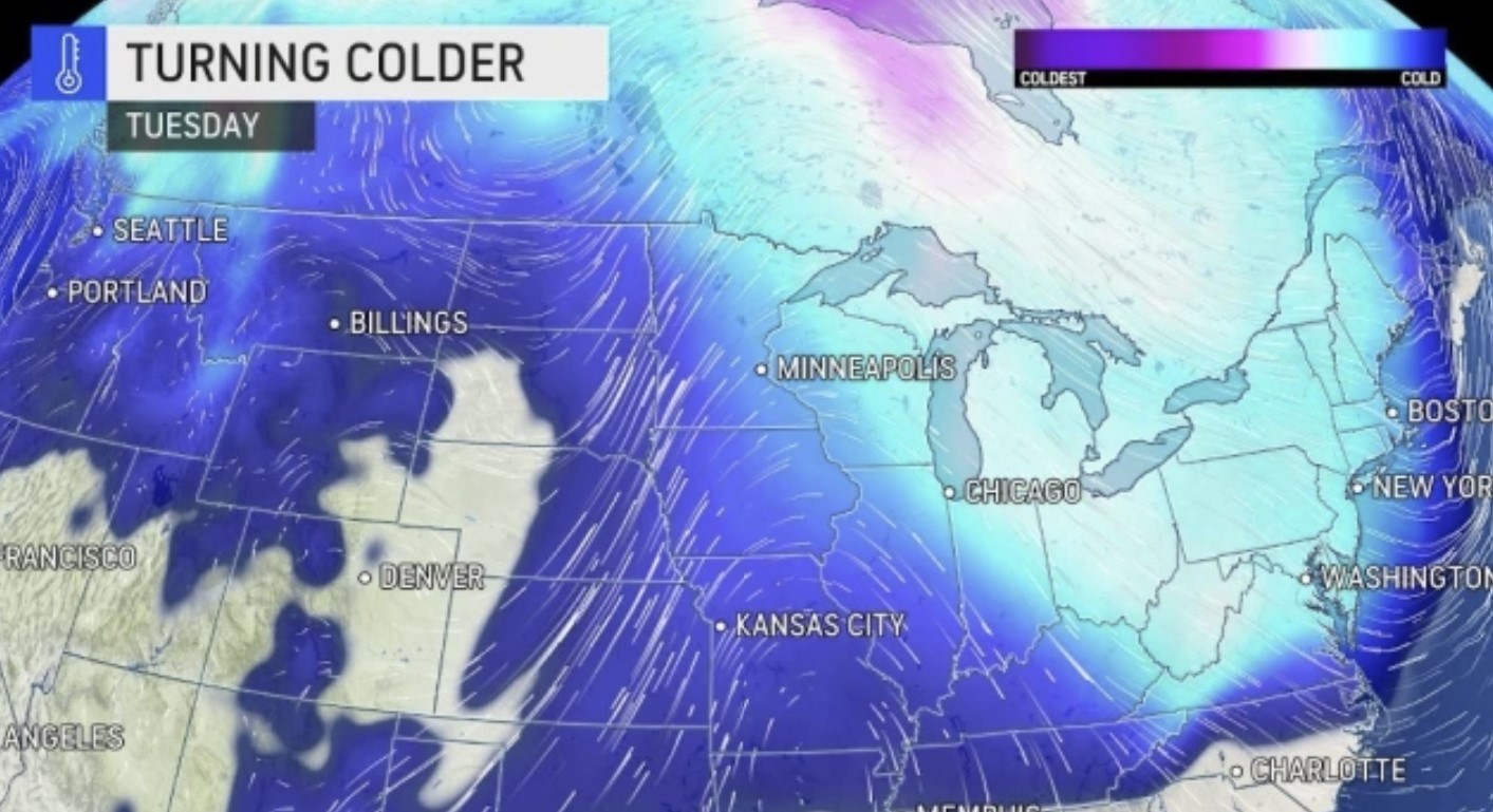
After a few days of mild conditions from Chicago to Philadelphia during the middle of last week, much of the East will feel temperatures that are 5-15 degrees Fahrenheit below normal Monday and Tuesday.
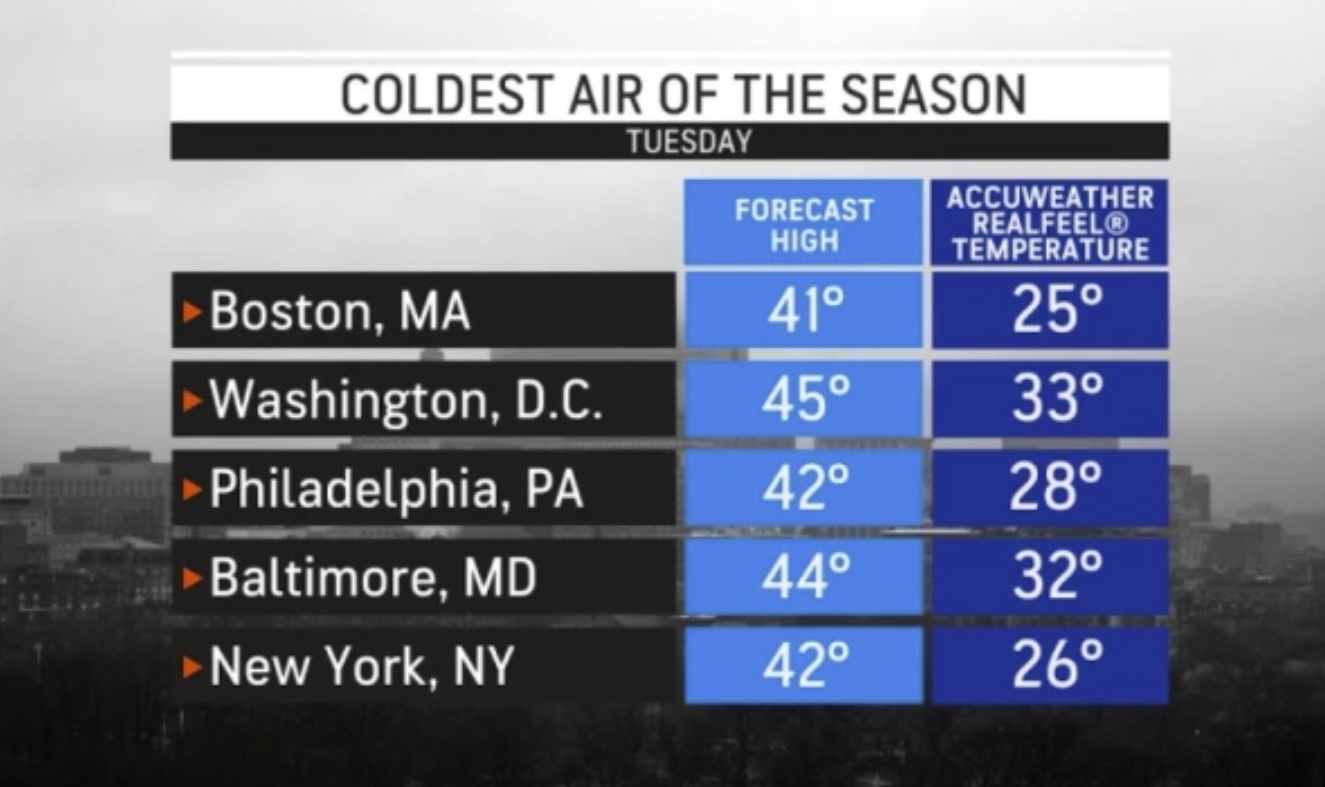
Temperatures along the Interstate 95 corridor from Baltimore through Bangor, Maine, will struggle to reach the low 40s on Tuesday, but a cold wind will make it feel even colder. Temperatures are predicted to top out in the 20s and low 30s in the Northeast’s big cities on Tuesday.
The colder-than-normal conditions will not be limited to just the Northeast. High temperatures may not climb out of the 40s as far south as Raleigh and Asheville, North Carolina.
The normal high in Raleigh for Nov. 23, is 61. From Boston to Washington, D.C., normal high temperatures are generally in the upper 40s to lower 50s.

A blustery wind will also add to the cold. Those heading out first thing Tuesday morning across much of the interior Northeast will find AccuWeather RealFeel® temperatures in the lower teens and single digits.
RealFeel® temperatures in the 20s are forecast as far south as Wilmington, North Carolina, where a widespread frost and freeze is expected. Even in the afternoon across much of the Northeast, RealFeel® temperatures will struggle to get out of the 20s and 30s.
Hats, gloves and scarves will be a must for kids waiting for the bus or walking to school. Tuesday morning will feel more like a late January rather than late November.
The cold blast will be short-lived, however, as temperatures rebound into the upper 40s to middle 50s in parts of the East, and just in time for Thanksgiving.
Parade of storms to resume in Northwest after devastating floods, mudslides
Another train of storms is expected to race through the hard-hit areas of the Pacific Northwest and British Columbia, Canada, this week.
Thousands of residents have been displaced, forced to ration gas and left stranded due to destroyed roadways after a powerful atmospheric river created a once-in-500-year flood event that devastated parts of Washington state as well as British Columbia last week. At least five total fatalities were reported across the United States and Canada as rescuers search through the rubble that was caused by over 10 inches (254 mm) of rain in places.
The weekend ended quietly across the region, but the tranquil weather is not expected to last long. AccuWeather forecasters are tracking multiple rounds of wet weather that could impact some of the same areas as last week.
The first storm will arrive across the Pacific Northwest later in the day on Monday then slide into the Intermountain West by Tuesday. Rainfall will likely arrive along the coast and in the western portions of the region, including Seattle, and Vancouver, British Columbia.
By Monday night, rain is forecast to reach places like Portland and Medford, Oregon, along with areas farther inland, like Spokane, Washington, and Kamloops, British Columbia. On Tuesday, this storm will likely combine with another area of low pressure from the southwestern U.S. to bring snow and flurries to some of the Rocky Mountains, including Calgary, Alberta, and Missoula, Montana.
Forecasters predict the second round will be the one to really watch out for. This storm will unload heavy rain that could produce flooding and increase the risk of mudslides in the region.
“Multiple waves of moisture will lead to excessive rainfall in the Pacific Northwest later this week into this weekend,” said AccuWeather Storm Warning Meteorologist Dana Carron. The storm could cause road closures and urban flooding.
For those in the U.S., Thanksgiving will be a particularly wet holiday as several inches of rain could fall across western and northwestern Washington.
The Canadian side of the border might face the worst or more widespread impacts and particularly where flooding has already occurred. Mayor Henry Braun of Abbotsford, British Columbia, extended the flooding state of emergency to Nov. 29 as the city rushes to rebuild the dike ahead of the coming storms.
“Our fingers are crossed,” said the mayor, according to the Canadian Broadcasting Corporation.
One to two inches (25-50 mm) of rain will be likely in Seattle and Vancouver and Terrace, British Columbia, from Wednesday evening to Friday evening, local time. Beyond rainfall, another key element in how potentially dangerous this event could be is the warmth associated with it.
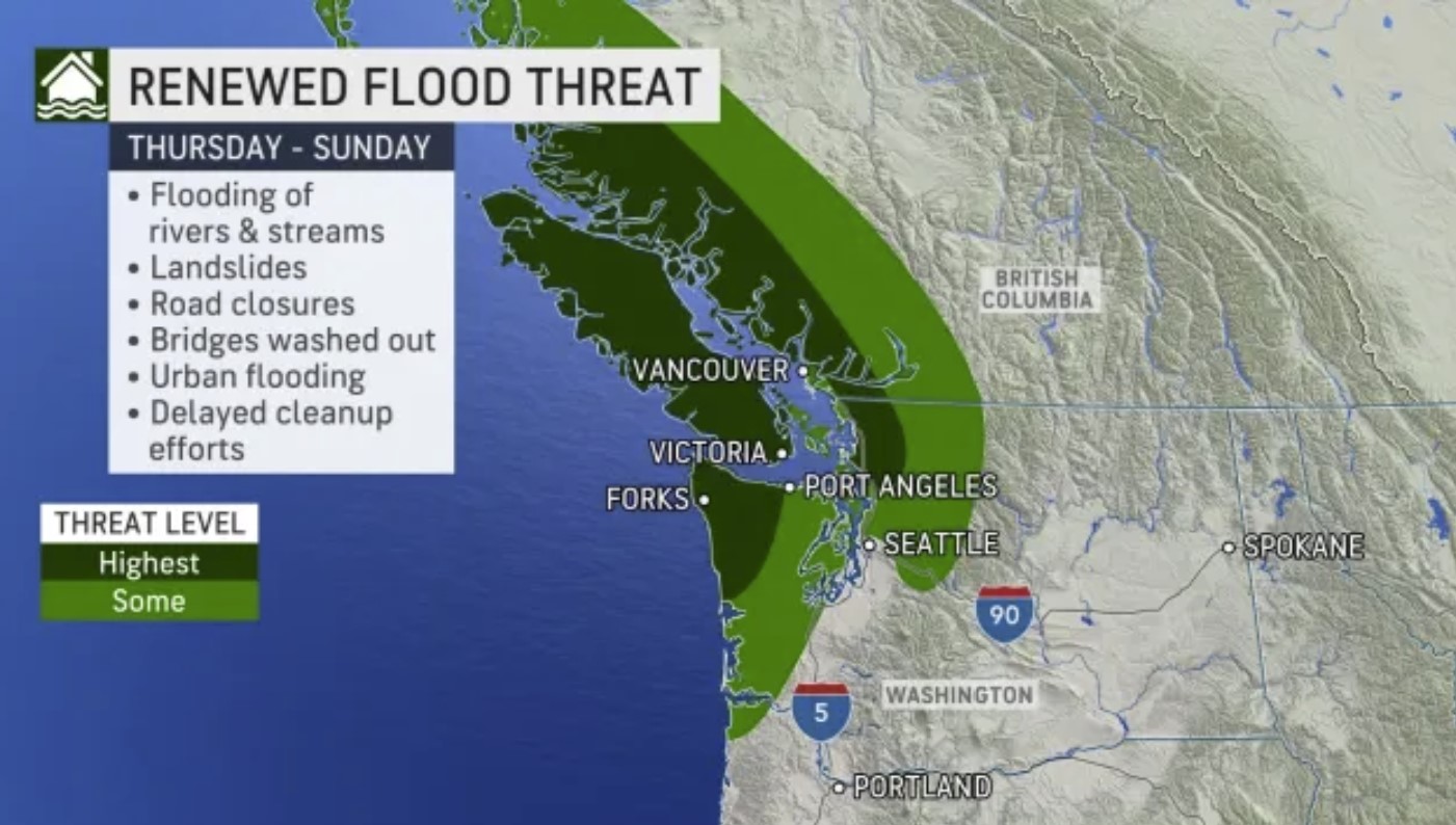
“Higher temperatures accompanying these systems will lead to snowmelt in the Washington Cascades and the Canadian Rockies which will further intensify the potential for flooding,” said Carron. This is expected to enhance the flooding of rivers and streams. If rivers or streams swell high enough, they could wash out roadways or even bridges, as was the case last week.
AccuWeather meteorologists deemed the areas with the highest potential for flooding will be across the Olympic Peninsula, Vancouver Island, the northern Cascades and areas of the Coast Mountains from the U.S. border to Terrace.
After this heavy rain event, warmer conditions will return next week, which could continue to melt snow across the mountains and worsen flooding issues. [ACCU1, ACCU2]
Now subscribe to this blog to get more amazing news curated just for you right in your inbox on a daily basis (here an example of our new newsletter).
You can also follow us on Facebook and/ or Twitter. And, by the way you can also make a donation through Paypal. Thank you!
You should really subscribe to QFiles. You will get very interesting information about strange events around the world.


 in 3 days of storm")


Well, that’s to be expected. We got down to 19°, and snow expected in 48-72 hours. I got my wood burning stove cleaned out. Use the ashes on tree basins. They love it.
Got a good woodpile under cover too. Sometimes, I bake potatoes in the oven, and crack the door. I double insulated, and did a stone exterior last season.
So, I can raise my home interior temp 9 degrees in 90 minutes using the bake potatoe factory heating system. Lol.
As long as USA we have Turkey in our plates , we are good.
Weather war fare is going to highest point. No one is safe from Quakes, Hurricanes,Floods, Disaster man made or AI made.
and of course false flag operations always can happen as well.
Milwaukee County DA admits it was a mistake to grant $1,000 bail to SUV-driving felon days before he smashed into Xmas parade: Darrell Brooks was freed after running over mother of his child and is now charged with homicide after killing five