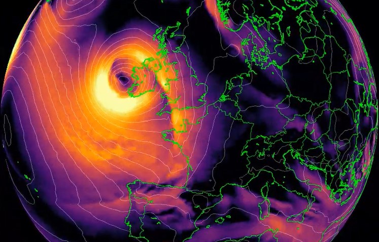
What started as a small disturbance in the Atlantic Ocean has explosively developed as a ‘weather bomb’ into Storm Barra, bringing strong winds, heavy rain and snow to Northern Ireland, with a yellow weather warning in place until 09:00 GMT on Wednesday.
A stormy afternoon to come
Strong winds ?
Heavy rain ?️
Snow in the north ❄️Stay #WeatherAware ⚠️#StormBarra pic.twitter.com/8WACD2qa8s
— Met Office (@metoffice) December 7, 2021
In the case of Storm Barra the fall between midday on Monday and midday on Tuesday went from around 1010mb to 957mb (53mb), more than twice the threshold to meet the criteria for explosive cyclogenesis (24mb drop in 24 hours). A DOUBLE BOMBOGENESIS!
Storm Barra blasting across the Atlantic as we speak.
Status red wind warnings have been issued for Cork, Kerry & Clare. Damaging gusts in excess of 130km/h will be possible. pic.twitter.com/QxZCKmEpAK
— Scott Duncan (@ScottDuncanWX) December 6, 2021
The approaching storm has resulted in the highest level of wind warning, red, for the counties of Cork, Kerry and Clare with gusts expected in excess of 130km/h. The warning for Cork and Kerry will be in effect from 6am to 9pm on Tuesday. The alert in Co Clare will be valid from 4pm on Tuesday until 1am on Wednesday.
Storm Barra blasting across the Atlantic as we speak.
Status red wind warnings have been issued for Cork, Kerry & Clare. Damaging gusts in excess of 130km/h will be possible. pic.twitter.com/QxZCKmEpAK
— Scott Duncan (@ScottDuncanWX) December 6, 2021
“This is a very rapid deepening of that system,” explained Met Éireann forecaster Aoife Kealy.
“The low pressure weather system gets caught up in the jet stream, the movement of air high up in the atmosphere. That suction of air reduces the weight and causes the atmospheric pressure to fall at sea level.
A mess of warnings across the UK with snow in the mix. Not ideal for the thousands that are still without power after Storm Arwen.
Official @metoffice warnings here: https://t.co/e14CQbSlUd pic.twitter.com/gzxtL4iqI1
— Scott Duncan (@ScottDuncanWX) December 6, 2021
“When the pressure falls at sea level like that, the system starts to suck in all the air around it which makes the air spin faster. It’s like an ice skater who, when they draw their arms in, spins faster and faster.”
That is why really strong winds can be found around a system which has deepened rapidly.
A mess of warnings across the UK with snow in the mix. Not ideal for the thousands that are still without power after Storm Arwen.
Official @metoffice warnings here: https://t.co/e14CQbSlUd pic.twitter.com/gzxtL4iqI1
— Scott Duncan (@ScottDuncanWX) December 6, 2021
Meanwhile, historic cold spell in Scandinavia:
A very impressive level of cold for this stage of December indeed. More on that stat via @extremetemps https://t.co/VfEluKGNTW
— Scott Duncan (@ScottDuncanWX) December 6, 2021
Up to 59,000 homes and businesses in Ireland have been left without power as Storm Barra made landfall, with winds predicted to reach 80mph as it crosses east throughout the day. It is understood this number has increased from 25,000 to 59,000 within an hour.
Heavy rain and sleet was expected on Tuesday as Barra continued its path from the Atlantic. Snow was already falling in the north-west of the country.
The Barnesmore Gap in Donegal this morning @MetEireann @donegalcouncil @RTENationwide @barrabest @TeresaMannion @WeatherRTE @iweatheronline @DonegalWeatherC @deric_tv @OceanFmIreland @DalysDonegal #StormBarra #StaySafe #Sneachta pic.twitter.com/e4qFvnagcM
— Cllr Marie Casserly. (@Marie_Casserly) December 7, 2021
The national weather service, Met Éireann, said the storm, which was likely to reach the UK within hours, could pose a danger to life over the next two days.
The UK was also braced for 80mph winds and heavy showers when Barra makes landfall, less than two weeks after Storm Arwen caused significant damage to parts of the country.
Flooding on Morrison’s Island just now, Quays are flooded so avoid if possible. @CBA_cork #StormBarra pic.twitter.com/JHZ7sO2LOw
— Eoin O’Sullivan (@Eoinmpos) December 7, 2021
Power cuts were reported in Cork, Kerry, Dublin and Limerick and people in three counties on the west coast advised to remain indoors.
Flooding in Cork and Kerry rendered several roads unpassable because of water or fallen trees.
?High tide passed in @corkcitycentre this morn with flood waters flowing across South Mall from the riverside quays at Morrisons Island
?⚠️Due to a red weather alert until 9pm this evening, the public are being urged to stay at home #StormBarra #CorkFloods pic.twitter.com/UFvWtct5ng
— Cork City Council (@corkcitycouncil) December 7, 2021
The storm coincided with high tide in Cork city, with flood waters flowing across South Mall from riverside quays in Morrison’s Island.
Lavitt’s Quay area has some surface flooding #Cork @corkbeo @CorkSafetyAlert pic.twitter.com/7AEx4zg77X
— Auctioneera (@AuctioneeraIre) December 7, 2021
A rare red weather alert was in place counties Cork, Kerry and Clare, and orange wind warnings were issued for Limerick, Waterford, Galway, Mayo, Wexford, Dublin, Louth, Wicklow and Meath.
Newcastle Harbour getting an absolute battering #StormBarra pic.twitter.com/IJcDD9mA3X
— Seán Webb (@seanwebb87) December 7, 2021
Also big waves are at the rendez-vous! Imagine now the giant waves off the coast (up to 14 meters in forecast!)
Big waves Isle of Man ?? #stormbarra #StormHour pic.twitter.com/QrW0oVAlwj
— Meraki_IOM ?? (@Meraki_IoM) December 7, 2021
Maybe something like that?
Storm Barra creating huge waves on the Atlantic in Bundoran.??
? Sean Carty pic.twitter.com/JF6Hg4Q7NS
— Chris (@mcgceltic) December 7, 2021
Schools in 12 counties subject to red and orange warnings were advised to close, while Aer Lingus cancelled all flights in and out of Cork with some services disrupted in Dublin.
What started as a small disturbance in the Atlantic has explosively developed as a ‘weather bomb’ into Storm Barra. ?
Ireland will feel the full force with gusts already up to 70mph in county Cork ? pic.twitter.com/u7Ed56zJln
— Simon King (@SimonOKing) December 7, 2021
In the UK, the Environment Agency issued three flood warnings for England’s south coast, as well as 35 flood alerts.
Yellow snow warnings were in place in northern England and Scotland, with blizzards and snowfall of up to 20cm causing treacherous conditions on roads at higher altitudes, the Met Office said.
Very unpleasant conditions in Donegal this morning. Recorded a little earlier, hands free #StormBarra pic.twitter.com/XhxkutpBcn
— Greg Hughes (@GregHughes2) December 7, 2021
The Met Office meteorologist Aidan McGivern said Storm Barra’s gusts and impact would be “a notch down” compared with Arwen, which led to widespread power cuts on 26 November, some of which had not yet been restored.Heavy rain was forecast in Northern Ireland and the south-west of the UK with drifting snow and blizzards turning heavy across northern hills.
On Monday, while about 1,600 households in the north-east of the UK were still without electricity almost two weeks after Storm Arwen struck, Boris Johnson said he had spoken to the chief executive of Northern Powergrid and had been “assured [customers] would be reconnected tomorrow at the latest”.
A lucky escape for a motorist at Newcastle this morning pic.twitter.com/xO23DYl9Gd
— Wicklow Fire Service (@FireWicklow) December 7, 2021
That evening the electricity supplier said it had reduced the number of homes and businesses affected to 700.
Ice was forecast overnight in parts of the UK before Barra’s arrival and the Met Office issued a yellow warning for potentially hazardous driving conditions in western Scotland and north-west England. [Irish Times, The Guardian, BBC]
Now subscribe to this blog to get more amazing news curated just for you right in your inbox on a daily basis (here an example of our new newsletter).
You can also follow us on Facebook and/ or Twitter. And, by the way you can also make a donation through Paypal. Thank you!
You should really subscribe to QFiles. You will get very interesting information about strange events around the world.


 in 3 days of storm")


It was certainly raining very heavily today, here on the west coast of southern England. I went for a walk and got a bit wet. But there are no warnings of anything “extremely dangerous”, at least not for the UK. The forecast is for strong winds and “small” chances of damage or travel disruption. For Ireland, however, it may be a lot worse.