From Oklahoma to Maine, over 115 million people will feel the impacts of a strengthening winter storm as it races quickly from the southern Plains to the Northeast through Friday.
“A dynamic winter storm is developing over the Southern Plains this morning and set to produce a plethora of weather hazards throughout the central and eastern U.S. through early Friday,” the Weather Prediction Center wrote Thursday morning.
That massive storm is putting millions of people across the country under winter weather alerts, flood alerts and wind alerts.
There is the possibility of tornadoes and flooding along the southern side and snow on the northern side of the storm system. Caught in between is the chance for a wintery mix and freezing rain.
Some will experience just one hazard, but some places including Indianapolis might get more than they bargained for. They are under a flood watch as significant rainfall is likely through the day today. Conditions will rapidly change to freezing rain, sleet, and then snow by this evening.
There is even a tiny chance that the city will see severe storms before the colder air rushes in.
Not everyone will experience all the impacts. Here are the different conditions expected and who is likely to see them.
Extreme winds and possible tornadoes
Damaging winds will be the primary threat as the ongoing storms this morning increase in intensity while they spread eastward throughout the day. Over 50 million people are at risk for severe storms, from Louisiana to Virginia.
“Damaging winds and a strong tornado or two will be possible,” the Storm Prediction Center writes.
Memphis, Nashville, Murfeesborough in Tennesse, Huntsville in Alabama and Jackson in Mississippi are most likely to see damaging winds. They are all under an enhanced risk — level 3 of 5 — for severe storms.
Some of these storms could also produce tornadoes.
The storms could begin to fire up in Arkansas by late morning, but that is uncertain. The more significant storm threat will arrive by midafternoon, moving west to east starting in western Tennessee down to Lousiana.
The primary risk for tornadoes will be centered over northern Mississippi, stretching from Jackson, Mississippi, to Memphis, Tennessee.
The risk continues through the evening, before diminishing overnight.
Along with the severe threat are the isolated pockets of potential flooding that come with severe thunderstorms. However, there is a higher risk of flooding on the northern fringes of the warm moist air colliding with colder air.
“The combination of frozen soil and melting snow will exacerbate flooding concerns throughout the Ohio Valley and Interior Northeast through tonight,” the prediction center said.
Flood watches and a slight risk — level 2 of 4 — of excessive rainfall reach from southern Missouri to western Vermont.
Rainfall amounts around 1 to 2 inches are expected in this region, with locally higher amounts.
The thing that could limit the flooding concerns will be the speed of the cold air. “The question remains as to how much precipitation falls as which precipitation type before cold air rushes in behind a cold front,” the prediction center said.
If the cold air arrives earlier than expected, this will limit the amount of rain and reduce the likely hood of flooding.
A swath of half a foot of snow
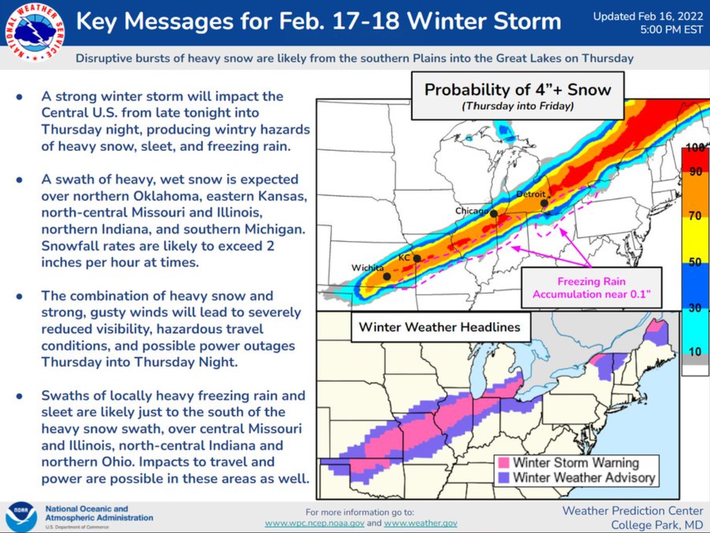
On the cold side of this system, a thin strip of heavy snow is likely to fall from northern Oklahoma to central Illinois by this afternoon.
This quick-hitting burst of snow will enter parts of northern Indiana, southern Michigan, and far northwest Ohio by the late afternoon or early evening hours.
“Snowfall rates exceeding 2 inches per hour and gusty winds could severely reduce visibility at times in these regions, with the heaviest snowfall amounts likely around 6 to 8 inches from eastern Kansas to southern Michigan, ” the prediction center said.
Just south of the heavy snow, sleet and freezing rain will fall before any snow.
Models show a line of freezing rain and sleet along the edge of the cold air from Missouri all the way into Ohio.
It will likely be a quick transition from ice to snow but even the littlest bit of ice can make conditions more hazardous.
When snow falls on top of the ice, it is more challenging to drive on and the ice also adds weight to branches and power lines.
But it isn’t just the Midwest. All the way up to Maine, people are likely to see rain transition over to winter weather as the cold air advances through. “Winter Storm Warnings and Winter Weather Advisories span over 1,500 miles from western Oklahoma to northern Maine,” the prediction center said.
The quick-hitting storm will leave almost as quickly as it arrived. Snow will end in the Midwest by this evening and end in New England by Friday afternoon.
Gusty winds cause travel hazard
If anyone has escaped the hazards of snow, severe storms and flooding, they likely won’t also escape the high winds ahead of this system.
Wind warnings and advisories stretch nearly 2,000 miles from Texas to Maine signifying southerly winds ahead of the storm that could become hazardous at times.
“Wind gusts up to 50 mph could lead to power outages where trees have been weakened by recent ice storms, as well as hazardous travel conditions for high profile vehicles.” the prediction center warned.
Parts of southern New England could see wind gusts as high as 65 mph tonight. [ABC17News, CNN]
Related: The best filter to remove PFAS from your drinking water at home…
Support my work
If you follow my website, you already know that my site has been banned from ALL ADS NETWORKS! So now I really count on you and your donations to keep Strange Sounds up and running! Support my work and family. Thank you for your help!
Paypal Donation Link
If you use Amazon, you can also use our link below, to enable us getting a small affiliate revenue. Thanks again!
Support Us With Amazon
Galileyo is your go-to destination to get uncensored news from the people you trust, directly to your satellite phone. Get a sat phone for a small monthly fee and be able to communicate with your loved ones and receive news during any disasters. Be ready! Get prepared
Subscribe to Galileyo
If you are looking for a 100% lightning and EMP protection for your home and car, EMP-Shield is the right product for you! Get a 50$ discount on any of your purchase using coupon: strangesounds…
EMP Shield Coupon: strangesounds
You should really subscribe to QFiles. You will get very interesting information about strange events around the world.


 in 3 days of storm")


