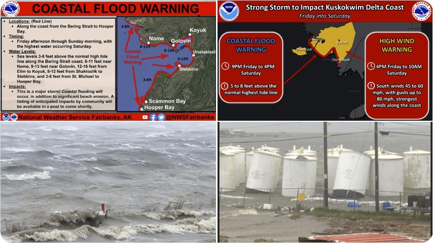
The strongest storm in a decade could be upon Alaska’s western coasts this weekend as forecasters warned of a front bearing hurricane-force winds, massive seas, and enough rain for coastal flooding.
Prepare now! Protect your home and cars againts EMP, solar flare and lightnings…
A low pressure front in the Bering Straight is spinning as wide and strong as any winter storm, but instead of bringing cold weather, it is being fed by the volatile air from the former Typhoon Merbok, forecasters said.
Reports of wind damage and flooding continue to come in tonight from across the Bering and coastal W. Alaska. This is just the beginning. We will continue to see strong winds into Saturday and flooding from an extreme storm surge all the way up the west coast.#akwx pic.twitter.com/5oxBfryiR8
— Melissa Frey (@MelissaDFrey) September 17, 2022
Praying for Hooper Bay friends and our other communities in western Alaska during this massive storm ?
? Ervin Chayalkun pic.twitter.com/vmZYVdbMbY
— Karrie Pavish Anderson (@KPAsing) September 17, 2022
The result is a potent system that could bring 3 to 5 inches of relatively warm rain to coastal regions over the weekend, and will impact Alaska’s Arctic coast, Southwest Alaska and, eventually, the Gulf of Alaska coast, forecasters said.
It’s now dark on the entire storm. This loop is from 730pm to 1120pm AK time, 3 hours and 50 minutes long.
Hope everyone does as well as they can tonight. pic.twitter.com/0wxmMwsVOW
— NWS Alaska Region (@NWSAlaska) September 17, 2022
“It derives its energy from the warm sea surface,” said National Weather Service meteorologist Alan Shriver, who spoke from Anchorage. “This is an exceptionally rare event.”
The strongest storm in over a decade is moving into the Bering Sea. Impacts may exceed the 2011 Bering Sea Superstorm, and some locations may experience their worst coastal flooding in nearly 50 years. Peak water levels will persist for 10 to 14 hours before water recedes. #akwx pic.twitter.com/l1Ik4iXYBG
— NWS Fairbanks (@NWSFairbanks) September 15, 2022
The National Weather Service office in Fairbanks warned the storm could be the strongest in over a decade.
Get Prepared… That’s the best pump for your home/basement against flooding…
“Impacts may exceed the 2011 Bering Sea Superstorm, and some locations may experience their worst coastal flooding in nearly 50 years,” it said in a tweet. “Peak water levels will persist for 10 to 14 hours before water recedes.”
For reference, my village has an elevation of 26 feet above sea level.
The electric utility (AVEC) has fuel tanks tipping over in the wind, boats floating away, & evacuated relatives saying they had to wade through waist deep water. Cousins with water literally to doorsteps. pic.twitter.com/Yid53hg2bb
— Angutekaraq (@AlaskaGirl74) September 17, 2022
Buoys have recorded waves of more than 50 feet in the south central Bering Sea, and the lowest pressure ever measured in the sea in September was recorded Friday, but remains unverified, Shriver said.
Updated weather and wave observations from NOAA buoy 46035, located in the south central bering Sea 275 miles (450km) west of St. Paul Island. Max significant wave height was 51.8 ft (15.8 m). #akwx @Climatologist49 pic.twitter.com/lDWPmKlrFI
— Rick Thoman (@AlaskaWx) September 16, 2022
The state Division of Homeland Security and Emergency Management has called for a heightened state of awareness because a “strong storm” was en route.
Prepare now! You will never go without electricity with this portable power station!
Hurricane-force gusts — wind speeds greater than 74 mph — have been recorded off Adak Island, part of the Aleutian Islands, Shriver said.
“There hasn’t been a September storm this strong in the northern Bering Sea region in the past 70 years,” tweeted Rick Thoman, a climate specialist with the Alaska Center for Climate Assessment and Policy.
There hasn’t been a September storm this strong in the northern Bering Sea region in the past 70 years. Friday 10pm AKDT forecast pressure and wind speed. Historic level coastal flooding Saturday into Sunday for many communities. #akwx #superstorm @Climatologist49 @knomradio pic.twitter.com/GeevYjguHF
— Rick Thoman (@AlaskaWx) September 16, 2022
Historic coastal flooding was possible, he said. A coastal flood warning and high wind warning was in effect Friday through Sunday for Alaska’s Southern Seward Peninsula Coast.
StrangeSounds.org is now entirely reader-supported. If you are going to make a charitable donation this year CLICK HERE TO SUPPORT MY WORK…
High winds and heavy rain can be expected for much of next week on mainland Alaska, federal forecasters said. In fact, the system could come ashore in two or three pulses, beginning overnight, according to the National Weather Service’s extended forecast for Alaska.
Rough conditions are being captured by this buoy in the western Aleutians as the remnants of Typhoon #Merbok move through the Bering Sea today! Significant, damaging high winds and storm surges are expected in SW Alaska, especially along the southern Seward peninsula. #AKwx pic.twitter.com/VHiouQyrED
— RadarOmega (@RadarOmega) September 16, 2022
Calm on the mainland was possible by the end of the week, forecasters said.
By then, however, Alaska’s winter weather machine may have already started churning out the kind of low pressure systems that are a trademark of December, January, February, and March — with a few days of summer still left on the calendar.
“It could be the start of our busy time of the year,” Shriver said. [NBC News]


Beautiful. Makes me feel small. My dad was stationed up there and all the storms went sideways. This one just went the other direction.
Extreme weather continues. Guess Japan and Australia expecting floods as well. Italy got like 16″ of rain in 2 hours!
Yeah, and this Winter is expected to be colder, Gary. Mockingbird media is not pushing any stories about areas in Europe, or globally that are experiencing unexpected cold temperatures. They peddle stories on heatwaves and droughts —only the global warming and greenhouse gaslighting horsecrap.