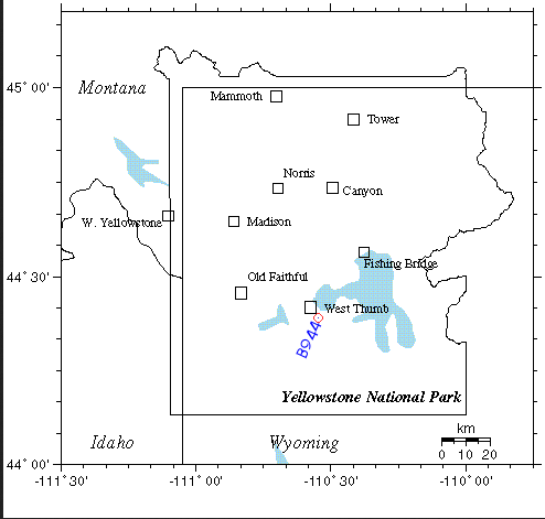
A seismometer inside a borehole at Yellowstone National Park has begun reporting staggering underground activity near the southwest corner of Yellowstone Lake, possibly signaling the beginning of an eruption of the Super Volcano at the Yellowstone National Park.

Yellowstone National Park is home to many beauties, with it’s ancient landscape, geysers, and hot springs. It is also the site of one of the worlds most destructive forces: A supervolcano.
However, new reports are coming in the a borehole (B944) at Yellowstone Lake (where most activity is) has shown some pretty intense movements.
Turner Radio Network states:
The activity began around 12:00 Noon, Mountain Standard Time (MST) on February 1, and was detected by a seismometer in Borehole B944 then continued, non-stop, all day yesterday getting worse and worse as the hours wore on. The activity is continuing right now at 6:06 EST AM as this news article is being produced.
Only time will tell on if these beast is ready to go, as it is technically “over do” for it’s next eruption. However, it could still be another million years before it does. This data could just a bark at the moon, however a large series of earthquakes occurred in and around the area. These links are below.
1.9 2014/01/31 09:55:29 44.798N 110.540W 4.4 30 km (18 mi) SSE of Gardiner, MT
1.1 2014/01/31 07:35:32 44.578N 111.145W 9.2 10 km ( 6 mi) SSW of West Yellowstone, MT
1.7 2014/01/31 06:25:39 44.834N 110.536W 6.9 26 km (16 mi) SSE of Gardiner, MT
1.2 2014/01/30 21:16:01 44.718N 111.203W 10.7 10 km ( 6 mi) NW of West Yellowstone, MT
1.9 2014/01/30 17:21:11 44.815N 110.532W 3.9 28 km (18 mi) SSE of Gardiner, MT
1.8 2014/01/30 15:02:27 44.807N 110.525W 6.9 30 km (18 mi) SSE of Gardiner, MT
1.8 2014/01/30 11:43:19 44.806N 110.540W 2.2 29 km (18 mi) SSE of Gardiner, MT
1.8 2014/01/30 09:42:11 44.812N 110.535W 4.9 29 km (18 mi) SSE of Gardiner, MT
1.4 2014/01/30 04:11:36 44.798N 110.537W 7.9 30 km (19 mi) SSE of Gardiner, MT
2.0 2014/01/30 04:11:35 44.808N 110.530W 7.4 29 km (18 mi) SSE of Gardiner, MT
1.8 2014/01/30 03:57:10 44.817N 110.533W 10.1 28 km (18 mi) SSE of Gardiner, MT
2.4 2014/01/30 01:40:35 44.807N 110.522W 11.8 30 km (18 mi) SSE of Gardiner, MT
2.2 2014/01/29 23:57:03 44.398N 110.615W 1.8 49 km (30 mi) SE of West Yellowstone, MT
1.5 2014/01/29 23:43:29 44.405N 110.628W 1.9 47 km (29 mi) SE of West Yellowstone, MT
1.3 2014/01/29 23:39:18 44.375N 110.636W -0.3 49 km (30 mi) SE of West Yellowstone, MT
1.4 2014/01/29 23:33:12 44.401N 110.627W 2.3 48 km (30 mi) SE of West Yellowstone, MT
1.5 2014/01/29 18:29:59 44.801N 110.544W 4.3 29 km (18 mi) SSE of Gardiner, MT
2.3 2014/01/29 01:11:08 44.600N 110.153W -3.4 49 km (31 mi) SSW of Cooke City-Silver Gate, MT
1.5 2014/01/28 04:39:47 44.815N 110.528W 7.3 29 km (18 mi) SSE of Gardiner, MT
1.4 2014/01/27 19:44:29 44.747N 110.780W 6.2 27 km (17 mi) ENE of West Yellowstone, MT
Yellowstone activity
On average, Yellowstone’s Caldera erupts about every 640,000 years. According to the analysis of earthquake data in 2013, the magma chamber is 80 km (50 mi) long and 20 km (12 mi) wide, and is shaped like 4,000 km3(960 cu mi) underground mass, of which 6–8% is filled with molten rock.
The upward movement of the Yellowstone caldera floor between 2004 and 2008 rose almost 3 inches (7.6 cm) each year and was more than three times greater than ever observed since such measurements began in 1923. By the end of 2010, geologists stated that the ground swelling has slowed down significantly.
This link gives a LIVE access to the Borehole data I reported. Archives of that Borehole (B944) Data are available for Feb. 1 and for Feb. 2. In addition, LIVE readings from ALL the boreholes are available here.


[…] This Email sent out explains all the preparations in Fema Region Three and all the supplies being moved to the East Coast. Fema Coffins and all the Military Build Up preparing for Gun confiscations and Martial Law. What would Happen If Yellowstone Erupted. http://www.youtube.com/watch?v=q14nrq… Yellowstone in the Mainstream January 7th 2014 Hmmm… http://www.youtube.com/watch?v=9tUe3X… Very Interesting Link from the ATS Forum. http://www.abovetopsecret.com/forum/t… More Links https://strangesounds.org/2014/02/is-y… […]
[…] time, it is not an imminent eruption, but melting roads! Yes, underground heat from the park’s super volcano and the warm summer […]
[…] earthquakes in the north-central part of the park, than you observe that with the latest swarms in February 2014 and April 2014, earthquakes are elevated. The previous uptick in earthquakes in this part of the […]
That’s “its ancient landscape” and “overdue.” Hard to trust the facts if they aren’t presented competently.
just bend over and kiss your A#$# good-bye.
[…] https://strangesounds.org/2014/02/is-y… […]
[…] A seismometer inside a borehole at Yellowstone National Park has begun reporting staggering underground activity near the southwest corner of Yellowstone Lake, according to https://strangesounds.org/2014/02/is-yellowstone-supervolcano-about-to-erupt-staggering-underground-a… […]
http://volcanoes.usgs.gov/activity/status.php (click on yellowstone):
“A borehole seismometer called “B944″, located near the West Thumb region of the Park, has been malfunctioning in recent weeks with strong bursts of electronic noise contaminating its data. These noise bursts appear as wild excursions on the B944 webicorders that can appear alarming to the inexperienced eye.”
and you trust the govt word on this because?
[…] Is Yellowstone Supervolcano About to Erupt? Staggering Underground Activity At Yellowstone Lake – … […]
[…] This here is a normal seismograph where not a lot is happening, all good here https://strangesounds.org/2014/02/is-yellowstone-supervolcano-about-to-erupt-staggering-underground-a… […]
[…] Is Yellowstone Supervolcano About to Erupt? Staggering Underground Activity At Yellowstone Lake […]