Off the coast of Washington, columns of bubbles rise from the seafloor, as if evidence of a sleeping dragon lying below.
But these bubbles are methane that is squeezed out of sediment and rises up through the water. The locations where they emerge provide important clues to what will happen during a major offshore earthquake.
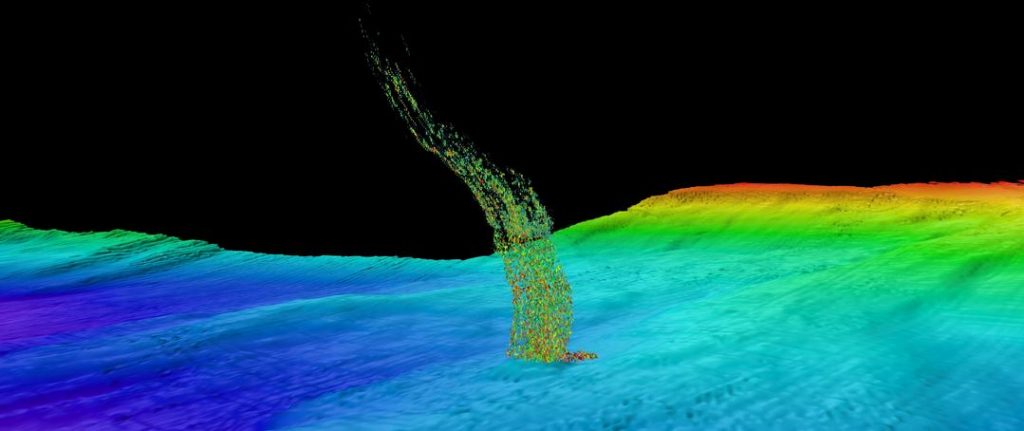
The first large-scale analysis of these gas emissions along Washington’s coast finds more than 1,700 bubble plumes, primarily clustered in a north-south band about 30 miles (50 kilometers) from the coast.
Scientists found the first methane vents on the Washington margin in 2009, and thought at the time they were lucky to find them. But since then, the number has just grown exponentially.
Results show, the gas and fluid rise through faults generated by the motion of geologic plates that produce major offshore earthquakes in the Pacific Northwest.
These vents are a little ephemeral. They’re not reliable, like the geysers at Yellowstone.
Sometimes they turn off-and-on with the tides, and they can move around a little bit on the seafloor.
They tend to occur in clusters within a radius of about three football fields.
The authors analyzed data from multiple research cruises over the past decade that use modern sonar technology to map the seafloor. Their new results show more than 1,778 methane bubble plumes issuing from the waters off Washington State, grouped into 491 clusters.
The vast majority of the newly observed methane plume sites are located at the seaward side of the continental shelf, at about 160 meters water depth.

Why Are Methane Vents Appearing Along Washington Coast?
The sediments off the Washington coast are formed as the Juan de Fuca oceanic plate plunges under the North American continental plate, scraping material off the ocean crust.
These sediments are then heated, deformed and compressed against the rigid North American plate. The compression forces out both fluid and methane gas, which emerges as bubble streams from the seafloor.
The bubble columns are located most frequently at the boundary between the flat continental shelf and the steeply sloped section where the seafloor drops to the abyssal depths of the open ocean. This abrupt change in slope is also a tectonic boundary between the oceanic and continental plates.
A previous study from the UW had suggested that warming seawater might be releasing frozen methane in this region, but further analysis showed the methane bubbles off the Pacific Northwest coast arise from sites that have been present for hundreds of years, and are not related to global warming.
Instead, these gas emissions are a long-lived natural feature, and their prevalence contributes to the continental shelf area being such productive fishing grounds.
To understand why the methane bubbles occur here, the authors used archive geologic surveys conducted by the oil and gas companies in the 1970s and 1980s. They show fault zones in the sediment where the gas and fluid migrate upward until emerging from the seafloor.
Those seismic surveys over the areas with methane emission indicate that the continental shelf edge gets thrust westward during a large megathrust, or magnitude-9, earthquake. Faults at this tectonic boundary provide the permeable pathways for methane gas and warm fluid to escape from deep within the sediments.
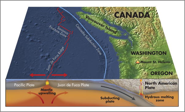
The location of these faults could potentially provide new understanding of the earthquake hazard from the Cascadia Subduction Zone, which last ruptured more than 300 years ago.
If the seafloor movement during a subduction-zone earthquake occurs closer to shore, and a major component of this motion occurs within the shallower water, this would generate a smaller tsunami than if the seafloor motion were entirely in deep water.
If this new hypothesis turns out to be true, then that has major implications for how this subduction zone works.
So now it’s time to get the real version of the story about the volcano threats on the U.S. West Coast and watch the most informative and spectacular documentary ever done on this subject here (click on the image below).
The study, from the University of Washington and Oregon State University, was published in the Journal of Geophysical Research: Solid Earth. [Washington University, AGU]


 HOLE into earth’s crust")


you say the area is a highly productive fishing ground ? could the methane be a reason for this ? I looked at a small study on rice and the addition of fish in 2 paddy fields showing 90% less methane in the one with fish in it, and with less fish in the ocean at that rate then it would have been harder to detect till fished out.