New video of the path of destruction of the 1964 Alaska earthquake

For the first time, a new computer model details the path of destruction of the enormous 1964 Alaska earthquake. It could help predict future quake damage in the state.

0
what is the largest quake ever recorded in the USA?, 1964 alaska earthquake, 1964 Alaska earthquake video, 1964 Alaska earthquake usgs video and photo, 1964 alaska earthquake photo, Great Alaskan Earthquake, the Portage Earthquake, Good Friday Earthquake, 1964 alaska earthquake is the largest quake ever recorded in the USA, us largest quake? largest quake in the USA
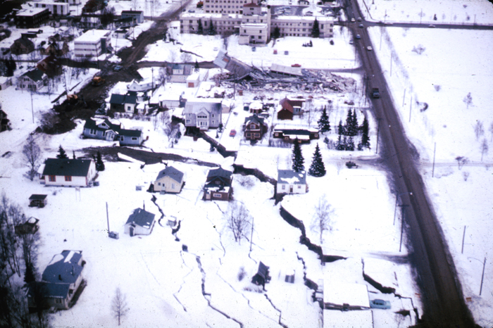
Damage from the magnitude 9.2 earthquake in Alaska on March 27, 1964. A subsidence trough (or graben) formed at the head of the L Street landslide in Anchorage during the earthquake. Note the collapsed Four Seasons Apartment Building and, behind it, the undamaged three-story reinforced concrete frame building, which is on the stable block beyond the graben. Photo Credit: USGS

What you see in this video is a simulation of the 1964 Alaska earthquake. Look at the powerful earthquake’s waves spreading through southern Alaska. It’s frightning!

Although scientists had thoroughly documented the shocking devastation from the Great Alaska earthquake, the actual spread of the seismic waves throughout the region wasn’t well understood. Read the abstract from SSA 2014 here.

Well now we really understand why we don’t want something similar happening again! Wow!

Follow us on Facebook and Twitter

Leave a reply

Please enter your comment!
Please enter your name here

This site uses Akismet to reduce spam. Learn how your comment data is processed.