Following an outbreak of severe weather from Texas to Mississippi on Saturday and Saturday night, violent storms are spreading eastward as the weekend comes to a close. A ‘large and dangerous’ tornado caused significant damage to Franklin, Texas, injuring dozens, uprooting trees and flipping trailers. Two tornadoes hit near Alto, Texas, within 90 minutes of each other. At least three deaths – 2 children and a man – have been attributed to the storms.

Texas
Powerful storms moved through the South Saturday, killing at least three people and spawning several tornadoes, including several “large and dangerous” twisters that left significant damage and caused dozens of injuries in East Texas.
7:34 AM Line of thunderstorms now moving towards Brackettville with a supercell in between Uvalde and Hondo. Main threat with the line is straight line winds and main threats with the supercell are hail, winds, and could be capable of a tornado. pic.twitter.com/t5pwEcdl7G
— NWS Austin/San Antonio (@NWSSanAntonio) April 13, 2019
A powerful thunderstorm slammed areas north of San Antonio with hail slightly larger than baseballs in diameter on Saturday morning.
@NWSSanAntonio just passed through Helotes pic.twitter.com/EvzAfuuYQH
— T'Challa TIMtation™ (@AvoidTIMtation) April 13, 2019
Large hail of similar sizes also pounded areas north of the Dallas-Fort Worth Metroplex.
Kyle Seale Parkway #eWXspotter pic.twitter.com/kBXY6I4xe7
— iliana b (@yanassurprise) April 13, 2019
The Angelina County Sheriff’s Office confirmed that two children, aged 3 and 8, were killed Saturday after a tree fell on the vehicle they were in during a severe storm. The children’s parents were able to exit the vehicle safely, the station added.
Damaged homes & structures in Franklin, Texas after a tornado moved through the area. pic.twitter.com/Eb6yyKxQNm
— WeatherNation (@WeatherNation) April 13, 2019
Meanwhile, a long-track tornado began Saturday morning south of Calvert, in Robertson County, before hitting the town of Franklin, located about two hours east of Waco.
"Was too far behind to get to the Franklin tornado, but did see some funnel clouds w/another supercell that blew up SE of the Franklin storm."
— Live Storm Chasers (@Livestormchaser) April 13, 2019
Permission By: Neil Sanger@weatherbug #TXwx #Tornado #Tornadoes pic.twitter.com/OQwFqH29rw
Preliminary survey shows it was an EF-3 tornado with winds of 140 mph.
11:27 AM: Those on US-79 northeast of Franklin (Robertson Co) need to find shelter immediately. A damaging tornado is likely ongoing just northeast of town. There are reports of damage just outside of Franklin. #ctxwx
— NWS Fort Worth (@NWSFortWorth) April 13, 2019
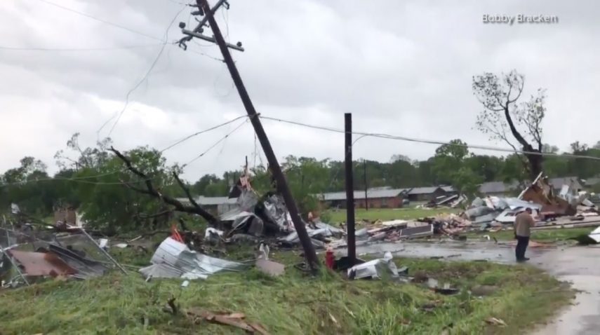
There have been reports of injuries, down trees, flipped trailers and damaged homes. There have also been reports of collapsed buildings downtown.
@KHOU Franklin tornado pic.twitter.com/07cJQ9Egt9
— Bobby Bracken M.Ed (@713BobbyB) April 13, 2019
Robertson County Sheriff Gerald Yezak told The Weather Channel there were numerous injuries, including many “walking wounded.” He said others were taken to the emergency rooms but he couldn’t say how many. He noted there were no reports of fatalities.
@KBTXShel pic.twitter.com/eGX8ob57Sy
— Timothy Delasandro (@K_percent) April 13, 2019
The tornado also damaged the Franklin Safari Park along Highway 79, but no animals escaped.
POWERFUL STORM: Franklin, TX took a direct hit from a tornado this morning! Widespread damage has been reported there, including overturned cars and downed power lines. Stay safe and make sure you have the @WAFBweather app to track storms as they move into our area. pic.twitter.com/msM4w2btYi
— Scottie Hunter WAFB (@ScottieWAFB) April 13, 2019
Several other tornadoes were confirmed in Texas Saturday, including two near the town of Alta from two different storms.
12:15 pm: Strong rotation is approaching and will cross I-45 between 2 and 6 miles south of Buffalo in Leon County. Another tornado could occur at any time. A car and sheltering underneath a highway overpass is not a safe place to be during a tornado!
— NWS Fort Worth (@NWSFortWorth) April 13, 2019
Tornado warned storm near Midway, Texas at 12:08 p.m. #Txwx pic.twitter.com/2de17FB3Q2
— Truth (@Sink_er_Swim) April 13, 2019
Jeremy Jackson, chief of police in Alto, said 25 people were transported from the Caddo Mounds area, where a field day event — the Caddo Culture Day — was underway when the storm hit. Jackson said the area took “a direct hit.”
On Friday, the historic site said a hike on Saturday was be canceled because of the forecasted severe weather but said the other events would go on “rain or shine.”
A fire department representative estimated the number of injured could be as many as 40. The official added that four or five people were critically injured, KTRE reported.
The Cherokee County Sheriff’s Office told KYTX there was at least one fatality in Houston County from the tornado, but no other details were provided.
Hwy 21 near alto. House swept off foundation. Found 1 person deceased on scene. @NWSHouston @NWSFortWorth pic.twitter.com/YW04ZJ55bi
— Brolin McKay (@UpdraftMedia) April 13, 2019
Jackson said dozens of home were destroyed and people became trapped by the storms. “I’ve seen brick homes flattened,” said Jackson. “I’ve seen homes moved across county roads.
Radar signatures consistent with a damaging tornado were observed across Robertson and Leon Counties. Damage surveys will take place in order to determine the number and intensity of tornadoes in these areas. Stay tuned for more information! #txwx #ctxwx pic.twitter.com/nZ0nX6QtsZ
— NWS Fort Worth (@NWSFortWorth) April 13, 2019
One of the two twisters caused a school gymnasium to collapse on one end. Damage to homes and a high school was also reported in Lufkin, Texas.
Storm damage at school in Alto, TX. Gymnasium collapsed on southern end. @docdeason @kjordan4588 @NWSShreveport @etxwx_josh #etxwx #txwx pic.twitter.com/UkyudWkkUC
— Micheal Lavender (@SkySPOT97) April 13, 2019
Air travel was significantly impacted at the Dallas airports. More than 500 flights were canceled Saturday at Dallas-Ft. Worth International Airport. Another 300 were delayed, according to Flight Aware. Flights headed to Dallas Love Field Airport were not allowed to depart before 1 p.m. CDT Saturday.
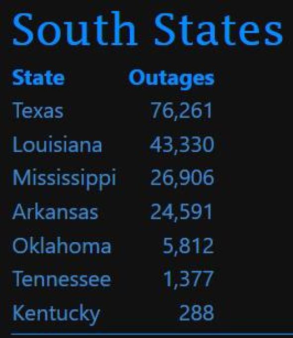
More than 50,000 customers were without power as a result of the storms in Texas by Sunday morning, according to poweroutage.us. Over 30,000 people were still without power as of Sunday at 5:00 a.m. EDT.

Louisiana
In Louisiana, an image taken Saturday morning in Stonewall shows what could be another tornado.
Stonewall Louisiana 10 minutes ago… @spann @JimCantore @TWCBreaking @Ginger_Zee @ReedTimmerAccu pic.twitter.com/4zxWE2Q36Q
— James Wilson (@nmjameswilson) April 13, 2019
Damage, including downed large trees, was also reported near Blanchard, Louisiana.
Storm damage pictures from Blanchard, LA #lawx @NBC6News pic.twitter.com/FyKn2qcxMb
— John Walton (@John_Walton_) April 13, 2019
By 5:00 a.m. EDT Sunday, more that 20,000 customers were still without power in Louisiana.
Mississippi
A confirmed large and extremely dangerous tornado was reported 8 miles northwest of Caledonia, Mississippi, moving north at 35 mph. The National Weather Service was calling this a life-threatening situation and urging people to seek shelter.
Tornado Warning continues for Smithville MS, New Hamilton MS, Hatley MS until 11:45 PM CDT pic.twitter.com/bYbl5IIybT
— NWS Memphis (@NWSMemphis) April 14, 2019
The break of dawn is shedding new light on the devastation in Hamilton, Mississippi, where a deadly tornado ripped through on Saturday night.
First light reveals the level of devastation in Hamilton, MS. @spann @WCBINEWS @WCBIWEATHER @NWSMemphis pic.twitter.com/IHdHVbMuEy
— Jacob Dickey (@jacobdickeywx) April 14, 2019
Multiple people were injured and multiple homes damaged, according to Monroe County Coroner Alan Gurley.
Video from this morning of the aftermath of the Hamilton, Mississippi, tornado. First images are of the fire department building, which was destroyed. #WTVA9News #mswx pic.twitter.com/EKMiEmcxL4
— Craig Ford (@cfordwtva) April 14, 2019
At least one mobile home was destroyed, throwing a man from the structure. Meanwhile, there are reports of fatalities.
Vicksburg, Mississippi TORNADO!
— Live Storm Chasers (@Livestormchaser) April 14, 2019
Permission By: Jay Parmigiani – 10 South Rooftop Bar & Grill@WeatherBug #LAwx #MSwx #ARwx #Tornadoes pic.twitter.com/OrhuNX4tmM
At Mississippi State University 21,000 students sheltered in basements and hallways. Debris and downed trees were spotted on campus but no injuries were reported.
Trees are down and roads are impassable right next to Aspen Heights near Mississippi State Campus. #mswx pic.twitter.com/v7RRMrvZR5
— Christopher Pipkin (@ChrisPipkinWx) April 14, 2019
And across the deep south
The outbreak of severe weather will continue into Sunday morning across the Deep South. All facets of severe weather are anticipated this weekend, ranging from damaging wind gusts and large hail to frequent lightning strikes, flash flooding and tornadoes.
Meanwhile, the tornado danger continues farther east with a new tornado watch issued for much of northern and central Georgia, including the Atlanta metro area.
*** The Storm Prediction Center has issued a Tornado Watch for 75 counties in Georgia. The tornado watch area is approximately along and 50 statute miles east and west of a line from 55 miles northeast of Rome GA to 60 miles southeast of Columbus GA. #gawx #tornadowatch pic.twitter.com/T5fycel4op
— NWS Atlanta (@NWSAtlanta) April 14, 2019
Officials with the Masters Golf Tournament said Saturday it was changing its schedule on Sunday as the storms move eastward. Players will be grouped in threes and will start play early, with half beginning on the first tee and the other half beginning their round on the 10th tee.
The National Weather Service reports that a confirmed tornado is located 8 miles east of Tishomingo State Park, Alabama moving north at 45 mph:
Tornado Warning including Pleasant Site AL until 12:45 AM CDT pic.twitter.com/hby9fbULFA
— NWS Huntsville (@NWSHuntsville) April 14, 2019
A new tornado watch has been issued for portions of southern Tennessee and eastern and central Alabama until 9:00 a.m. CDT Sunday.
The tornado watch has been extended into Northeastern Alabama until 9 AM Sunday morning. A watch means conditions are favorable for a tornado to occur. Sever winds are also possible with this line of storms. #HUNwx #ALwx pic.twitter.com/MW2PpTsJf8
— NWS Huntsville (@NWSHuntsville) April 14, 2019
Emergency managers report that a possible tornado occurred in Hagler, Alabama. Trees and power lines were downed near the Hagler Volunteer Fire Department.
In addition to the continued risk of tornadoes and damaging winds across Alabama early this morning, flash flooding will also be a threat as the storms unleash a significant amount of rainfall. Parking lots are beginning to take on high water at the University of South Alabama’s campus.
Minor flooding is beginning to be a concern at USA with running water in the parking lots, as we received almost 2 inches of rain in about an hour. @NWSMobile #alwx #mobwx pic.twitter.com/COi8XMUN6U
— Peyton Barlow (@WXpebarlow) April 14, 2019
US Weather Chaos!
Follow us on FACEBOOK and TWITTER. Share your thoughts in our DISCUSSION FORUMS. Donate through Paypal. Please and thank you
[The Weather Channel, AccuWeather]


