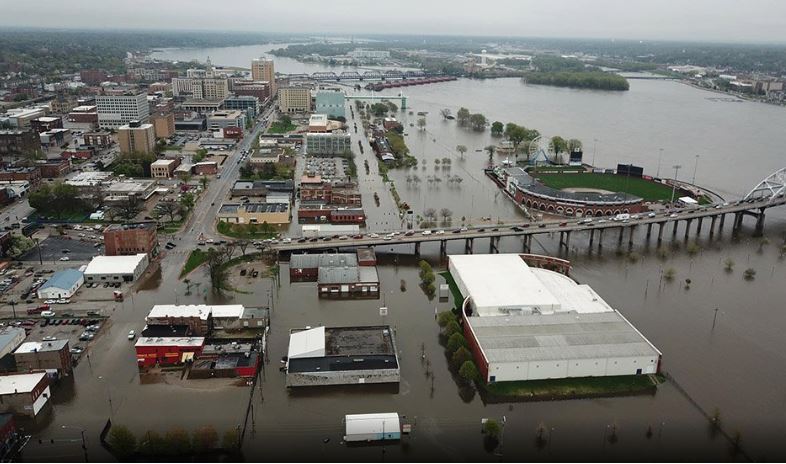
A portion of downtown Davenport, Iowa, was inundated with flood waters up to six feet deep after a temporary levee meant to hold back the rising Mississippi River failed Tuesday.

“The temporary flood protection levee that they put in place failed this afternoon and it’s inundating a portion of downtown Davenport,” David Donovan, Scott County Emergency Management Director, said.
@Weathermandavid flooding in Davenport IA leaves 1 dead due to drowning!! Flood walls broke cause evacuation for the city!! pic.twitter.com/egdHydfzYa
— YouTube DRAMA (@YouTube88870430) May 1, 2019
The flooding covered about four blocks of downtown Davenport, with water up to six feet high in some places.
Flood emergency: Breach in HESCO barrier in Davenport https://t.co/nU6hAxOeSh
— Local 4 WHBF (@Local4NewsWHBF) April 30, 2019
The flooded area is mostly a business district but there are some apartments. Fire rescue crews were going door to door in boats assisting with evacuations. Several businesses in the area were forced to close as the flood waters rose, and city workers scrambled to reinforce the levee with sandbags.
A temporary barrier failed on Tuesday, sending the #MississippiRiver into downtown #Davenport, Iowa. The river is expected to crest this afternoon, inches shy of the record set during the great flood of 1993. pic.twitter.com/uOUr53HLY8
— AMHQ (@AMHQ) May 1, 2019
The NWS issued a flash flood emergency for the area due to the breach, and several area roads were closed including Iowa Highway 22 from Davenport to Muscatine and US Highway 67 north of LeClaire.
Photos from the @wqad live blog: Take a look at these images coming out of downtown Davenport right now.
— Ryan Jenkins (@RyanJenkins_TV) April 30, 2019
A flood wall breach = dangerous flooding. Water creeping past 2nd Street
Crews are on the scene preforming rescues by boat.https://t.co/iIQQNAeaET pic.twitter.com/Eu7Xo4RjNc
The warning was lifted around 7:30 p.m. The weather service said the water had not receded, but was no longer rapidly rising. Residents were urged to avoid the area.
“Flooding will likely worsen tomorrow so please remain vigilant, follow directions from local officials and law enforcement, and be prepared to evacuate if necessary,” Iowa Gov. Kim Reynolds tweeted.
FLASH FLOOD EMERGENCY FOR DOWNTOWN DAVENPORT!!! Immediately seek higher ground if you are in this area! The Mississippi River flood waters may soon breach a portion of the flood barrier. Flash flooding may develop shortly. #iawx #ilwx #flood
— NWS Quad Cities (@NWSQuadCities) April 30, 2019
The NWS forecasts the Mississippi River to peak in the Quad Cities area, including Davenport, over the next couple of days. Water levels are expected to rise to within a foot off the all-time record high for the Quad Cities, which was 22.63 feet during the catastrophic Midwest floods of 1993.
“Because so much of the Midwest experienced heavy rain last fall, followed by the wettest winter on record, the soils remain saturated over a wide area,” Bob Henson, a weather.com meteorologist said. “It won’t take a great deal of rain to trigger additional flooding as the spring unfolds.“
Traffic lights still changing at 2nd and Warren Streets in Davenport.
— Ryan Jenkins (@RyanJenkins_TV) May 1, 2019
An old gas station is underwater.
Sandbags and pumps doing their best to keep water out of Mary’s on 2nd as water floods into the basement (@WQAD)
Coverage of #QCFlood2019 continues now on GMQC pic.twitter.com/jGXUb2KJBN
Meanwhile, Davenport is at the mercy of the rising floodwaters. “There’s nothing we can really do at this point … until the river recedes,” Donovan said.
And it’s just the beginning! Be prepared and get ready!


