An extraordinary weather event has been occurring above our heads on July 18, 2019.
A new totally unusual record has been broken: The strongest summer jet stream ever observed over the Pacific Northwest.
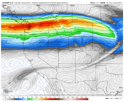
The jet stream is a narrow current of strong winds in the upper troposphere (roughly 25,000 ft to 35,000 ft above sea level). It is often the conduit for storms and is associated with a large temperature gradient in the middle and lower troposphere. Winds in the jet stream are westerly (from the west) and aircraft like to fly in the jet stream going east, while avoiding it going west. You are now Jet Steam certified!
The jet stream typically reaches its highest speeds during the wintertime, when temperature and pressure differences across the mid-latitudes are at their greatest. In the summer, there is also a greater amount of rising air (convection, which leads to thunderstorms) which can disrupt the jet. In the cold months, the jet stream usually maxes out around 160 knots (184 mph).
In February 2019, the New York National Weather Service recorded something that it never had before in our parts: a jet-level wind speed over 200 knots – approximately 231 mph!
Now on July 18, 2019, scientists at the radiosonde site at Quillayute (UIL) have measured the strongest summer jet stream ever observed over the Pacific Northwest with wind speeds of 140 knots (161 mph). This is amazingly fast for this time of the year.
Amazing and unusual record
Vertical soundings at Quillayute go back to the late 1960s… So we are talking about a half-century of observations here. As shown in the first diagram, the previous record was around 110 knots between April 1st and Octorber 15th (summer).
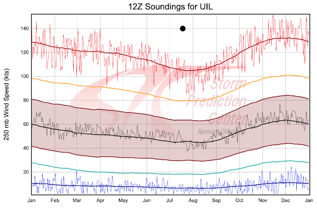
So the 140 knots observed on July 18, 2019, absolutely shattered the half-century-old record. In fact, the wind over us right now is greater then the records for any date from April 1 to mid-October.
Interestingly, a July-August record was set on the same day at the next upper air station to the south at Salem, Oregon, as shown in the diagram below:
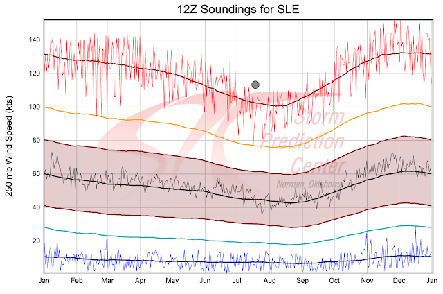
Those jet stream wind speeds look like January, not July. That’s another truly unusual weather event.
[Cliff Mass, NWS]


 scorches Brazil’s Rio de Janeiro")

We just don’t get four distinct seasons anymore like we did in years past. Traditionally the core of the jet stream was at 35000 feet across the USA and pilots could depend on it for most of the winter and spring starting late fall. It would hasten eastbound flights and slow westbound flights. But with all the volcanic activity and the continuous weather wars of HAARP, chem trails and who know what else is being deployed, you pretty much just have to take the weather minute by minute and be ready to divert course.
Correction on the Summer to Fall, and make that Fall to Winter changes. It is when one hemisphere, North or South, contains the faster half of the upper atmosphere wind speeds.
This is easily explained. If you look at the nullschool website with the selections of Air > Wind > 10 hPa, you will see that the top most atmospheric wind is displaying something that until recently was reserved for seasonal changes like from the Winter to Spring and the Summer to Fall changes. We were in a summer atmosphere early into the season, but the almost overnight it made a shift to change to Fall and is getting stuck in the middle of the shift.
Check it out here: https://earth.nullschool.net/#current/wind/isobaric/10hPa/orthographic Normally, North is blue in the center, near the North pole and surrounded by green (defined as slower wind speeds), and South is dark purple, surrounded with pink and white (defined as faster wind speeds).
Reason? Most believe it is the amount of volcanic ash in the atmosphere combined with our weakening magnetosphere and our sun’s weakening heliosphere allowing those cosmic ray intrusions of radiated cosmic ray particulates of hydrogen to merge with the oxygen in our uppermost atmosphere, which is also causing the noctilucent clouds to come down so close to us because of the atmosphere layer being so heavy laden with moisture (water vapor). My conjecture is that our atmosphere is being condensed into shallower layers, closer to the ground; hence, increased jet streams speeds lower to the ground.
Sounds like the Earth before the flood.
this makes me ask just how many ionosondes there are….ther are at least 2 more in texas and 1 in colorado….also the weather aspect is a new one on me because i thought they were used to track nvis radio communications …..