Within the past several days, weather phenomena that wouldn’t be out of place in the U.S. South happened in the far north…
And that’s king of worrying!
- Sea ice is running neck and neck with 2012 for the lowest values on record for this time of year.
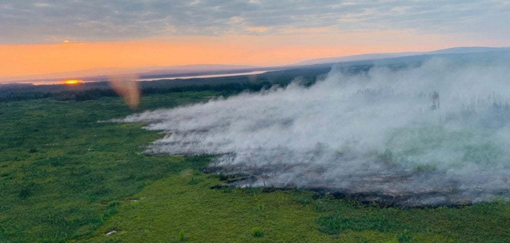
- Wildfires are ringing the Arctic, pouring more carbon dioxide into the air than in any comparable period in 17 years of satellite observing.
- Alaska saw its hottest month by far in almost a century of recordkeeping.
- And a surge of warm air with origins in last month’s record-devouring European heat wave pushed across Greenland at the end of July, melting 55 million tons of sea ice in five days. That’s an unprecedented rate in satellite records, and more than three times the average melt rate for 1981-2010.
#Greenland‘s ice sheet was melting at an unprecedented rate between 30 July and 03 August. The melt runoff was estimated at 55 billion tons or about 40 billion tons more than the 1981 – 2010 average for this same period. @NSIDC https://t.co/By47gUxApQ pic.twitter.com/9JZav9wV2o
— Copernicus EU (@CopernicusEU) August 11, 2019
Now in the past several days, weather phenomena that wouldn’t be out of place in the U.S. South happened in the far north… and that’s king of baffling!
Atmospheric River Floods Alaska, But a Record-Dry August in Southeast Alaska
August kicked off with a disorienting feed of tropical moisture from the typhoon-pockmarked Northwest Pacific into northern Alaska. Such atmospheric rivers do make their way into Alaska, especially in late summer, but in this case the moisture brought drenching rains across a vast area, including the heaviest 24-hour rainfall on record for Nome (2.43” on August 1-2), and widespread flooding.
Another round of heavy rain is expected late tonight into Friday. Most of Fairbanks North Star Borough will see over two inches of rain between late tonight and Friday afternoon. Here is map of the expected rainfall totals between 10 PM tonight and 10 PM Friday. pic.twitter.com/jYCxDCPMeX
— NWS Fairbanks (@NWSFairbanks) August 14, 2019
Early this week, another soggy surge of upper-level moisture swept into southwest and central parts of Alaska. The new surge will contribute to heavy rains across central Alaska that could lead to additional flooding later this week. With 4.28” of rain this month through Tuesday, Fairbanks could top its August precipitation record (6.88”, from 1930) by this weekend.
So far in the month of Aug, Fairbanks has received 4.28″ of rainfall. This makes 2019 the 4th wettest August on record with over half of the month left to go!
— NWS Fairbanks (@NWSFairbanks) August 14, 2019
Another significant round of rainfall is expected on Thursday and Friday, so we will add to this total.
And the moisture plume itself is already a record-breaker. At several locations separated by hundreds of miles, Tuesday brought the wettest atmosphere ever observed in the 70-plus years since regular radiosondes (weather balloons) have been launched over Alaska. This is based on precipitable water (PW), the amount of moisture in a column of air above the surface.
According to climatologist Brett Brettschneider, the following locations set all-time PW records:
Bethel, 12Z Tuesday: 1.86” (old record 1.77” from August 6, 1956)
Fairbanks, 0Z Wednesday: 1.59” (old record 1.57” from July 13, 1971)
Anchorage, 0Z Wednesday: 1.76” (old record 1.67” from August 26, 1990)
For perspective:
- There was more moisture in the air on Tuesday night above Anchorage than there was above Corpus Christi, Texas (1.73”), which sits on the Gulf Coast.
Precipitable water from the Aug 14, 0 UTC sounding:
— Brian Brettschneider (@Climatologist49) August 14, 2019
Anchorage, AK: 1.76″
Corpus Christi, TX: 1.73″@NWSAnchorage @NWSCorpus
- The amount of water above Anchorage would have beaten the all-time record for Salem, Oregon (1.73”).
If my sleuthing is correct, I think you’ve beat out all-time PW for Salem Oregon (KSLE), which is 1.73 inches. Congratulations!
— Larry O’Neill (@laoneill25) August 14, 2019
With the main jet stream absurdly far north, parts of southeast Alaska that are typically moist have been markedly dry this month. Even with the record amount of moisture sitting above it, Anchorage was able to squeeze out only a trace of rainfall on Tuesday. The city has seen no measurable rain all month — something that’s occurred on August 1-13 only once before (1969) in airport records going back to 1954. No rain is expected in Anchorage for at least the next week.
Juneau hasn’t seen measurable rain since July 29, making this the first August in 124 years of recordkeeping to go this long without rain. The city could get some sprinkles or spritzes starting Wednesday, and perhaps a bigger dose of rain toward the weekend.
Dry weather continues in Southeast. #Juneau is going for a historic dry record. As a rain forest rain usually comes often, but that has not been the norm this year. This is a bitter-sweet record in the making. #akwx #drought #AKdrought .@KTOOpubmedia .@JuneauEmpire .@800KINY pic.twitter.com/EGEtt9jGXn
— NWS Juneau (@NWSJuneau) August 12, 2019
Lightning Hits Near the North Pole?
Social media lit up this past weekend when a total of 48 lightning discharges were reported north of 85°N latitude, or within about 450 miles of the North Pole. The lightning came from low-topped, elevated thunderstorms that occasionally pop up over the Arctic, but seldom so close to 90°N. Elevated storms develop when moist, unstable air sits above cooler, more stable air near the surface. In this case, a surge of warm air swept toward the pole, riding atop much cooler air just above the mostly ice-covered central Arctic Ocean.
A number of lightning strikes were recorded Saturday evening (Aug. 10th) within 300 miles of the North Pole. The lightning strikes occurred near 85°N and 126°E. This lightning was detected by Vaisala’s GLD lightning detection network. #akwx pic.twitter.com/6jdxeMPBdH
— NWS Fairbanks (@NWSFairbanks) August 11, 2019
As it turns out, not all of these flashes were lightning strikes reaching the surface. Lightning is typically classified as intracloud (IC) or cloud-to-ground (CG) flashes. Of these, only a CG flash actually strikes the ground (or ocean); IC flashes play out above ground level.
The lighting near the North Pole was detected by the proprietary GLD360 monitoring system deployed by Vaisala, which is distinct from NASA’s satellite-based lightning sensors, whose coverage doesn’t quite extend to the planet’s north and south poles. GLD360 detects the electromagnetic signal produced by lightning flashes around the world, estimating the peak current and polarity of each discharge.
What’s most impressive about last weekend isn’t that lightning was detected so close to the North Pole, but that there was so much of it. Since observations began in 2012, only three prior lightning events were detected north of 85°N, and they produced a total of just nine flashes. By comparison, last weekend brought a total of 48 flashes to that region. All but seven of those were CGs.
In the larger area north of 80°N, a typical summer brings two to five events, with several dozen flashes in all. No single event on record had produced more than about 50 flashes until July 2018, when just over 300 flashes were observed on a single day. Last weekend, more than 1000 flashes were detected. About 80% of these were CGs.
Warmest Upper Levels on Record for Southwest Alaska Possible This Week
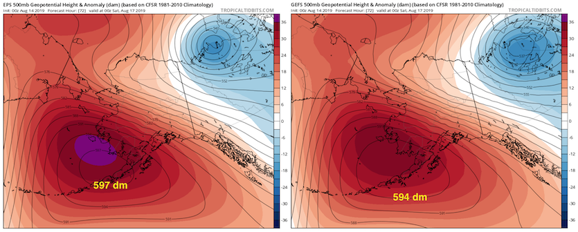
The upper-level ridging that’s scrunched Alaskan weather features north of their usual locations will peak later this week, in what could bring unprecedently warm air at upper levels. The 500-millibar pressure level — about midway up through the atmosphere’s mass — rises and falls as the atmosphere below it warms and cools.
Typically in August, the 500-mb surface is located about 562 decameters (18,400 feet) above Alaska. But by Thursday and Friday, both the GFS and European models are projecting that the 500-mb heights will soar to at least 590 dm, and perhaps above 594 dm, from southwest Alaska and the far northern Gulf of Alaska into the southeast Bering Sea.
These “high heights” will likely challenge some all-time records. Below is a sampling of such records for Alaska as compiled by Brettschneider. I’ve highlighted some locations to watch in bold.
Location, record-highest 500-mb height (in meters), date
Cold Bay, 5965, 8/14/1952
St. Paul, 5912, 8/10/1956
Kodiak, 5938, 8/11/1956
Anchorage, 5905, 8/12/2005
King Salmon, 5935, 8/11/1956
Barrow, 5869, 8/1/2002
Kotzebue, 5900, 8/1/2002
Nome, 5916, 6/25/1953
McGrath, 5920, 6/26/1953
Fairbanks, 5885, 8/11/2005
Yakutat, 5984, 7/24/2009
Annette Island, 5957, 9/7/1989
Shemya, 5970, 8/5-6/1981
The weather is going crazy! Be ready and prepared!
Read More:




This article is proof positive that man made climate change is happening due to the release of too much carbon dioxide into the atmosphere. Thus it is high time the US join all other civilized nations of the world in creating a one world system of cooperation for stopping climate change and imposing a carbon tax policy that will both help end climate change or at least start getting it under control and at the same time fund the underfunded climate researchers and UN staff working diligently to get this problem under control before the time comes runaway climate change will be too late to stop and ruin the ecosystem as we know it. Please write to your US Senator, President and Representatives, begging them to get on board with the UN climate change treaties and begin funding more research to increase alternative ways of capturing free energy from the sun and wind and increasing the efficiency in how it is utilized, so that all humans of all races, religions, sexes, creeds and origins will prosper well into the future. I applaud this article for demonstrating beyond the shadow of a doubt how runaway carbon dioxide release is destroying the world’s delicate climate system, which we as God’s keepers here on earth, are ordered to save in all ways possible.
Globalist propaganda machine at work. Normal climate cycles including colder than normal temperatures in many regions are now “the beginning of the end”. According to the “Global Warming” narrative the Arctic was supposed to be ice free during the summer ten years ago. Still 2 meter thick ice covering most of the Arctic during the summer. Let’s not look at data or deal in facts. Let’s make our own reality.
It’s all cyclical…global cooling is being observed globally…most of the climate changes occur in cycles around the globe, and nationally as well. many places that were normally dry will become moist, and vice versa, only to return to a new “normalcy” after a decade or so. A lot of it hinges on the solar cycles of 11 years avg. and the earth’s outer atmosphere content. This has happened before during the Bristish search for a Northwest Passage in 1817, after the end of the Little Ice Age in late 1700’s (Revolutionary War–Washington crossing the frozen Delaware, London Thames freezing over etc). Better to prepare for enhanced food, energy, and water supplies.
In related news, the earth’s magnetic poles are indeed shifting wildly. North pole is shifting 30 miles west each year (or 1 degree west every 5 years). This will affect ocean habitats and migratory wildlife….the poles are noted to “flip” every 400,000 years or so, over a 10,000 year process. No worries yet for humans though, except for extremely subtle changes in GPS and similar signaling.
not too worry if it goes slow if it goes fast most of us wont live long enough to be worried by whats happening how long can a human live in a 700 to 2100 mph wind that could last for several hours as in 2-5 hours…but this will only happen if the earths crust dicides to flip along with the magnetic poles x how far and how fast this shift take place….
At the same time it was unusually warm in Alaska cold temperature records were being set in the US Midwest and Southeast along with some places in central Europe. It’s funny that those cold temperatures don’t get the same press that warm temps do. I guess that’s because they don’t support the global warming narrative being shoved down everyone’s throat.
Ohhh, it’s so scarrrryy!