For the first time, an international team of scientists has combined magnetic data from ESA’s Swarm satellite mission together with aeromagnetic data to help reveal the mysteries of the geology hidden beneath Antarctica’s kilometers-thick ice sheets, and link Antarctica better to its former neighbors.
Not only is Antarctic sub-ice geology important to understand global supercontinent cycles over billions of years that have shaped Earth’s evolution, it is also pivotal to comprehend how the solid Earth itself influences the Antarctic ice sheet above it.
The research team from Germany’s Kiel University, the British Antarctic Survey and National Institute of Oceanography and Applied Geophysics, and Witwatersrand University in South Africa has today published their findings in the Nature journal Scientific Reports.
Their new study shows that combining satellite and aeromagnetic data provides a key missing link to connect Antarctica’s hidden geology with formerly adjacent continents, namely Australia, India and South Africa — keystones of Gondwana.
The fact that Antarctica is about as remote as you can get and the land below is covered by a massive ice sheet, makes collecting geophysical information both challenging and expensive. Fortunately, satellites orbiting above can see where humans cannot.
Thanks to magnetic data from the Swarm mission along with airborne measurements, scientists are paving the way towards understanding Earth’s least accessible continent. This new research links Antarctica to its ancient neighbors with which it has shared a long tectonic history — and that needs piecing together like a jigsaw puzzle.
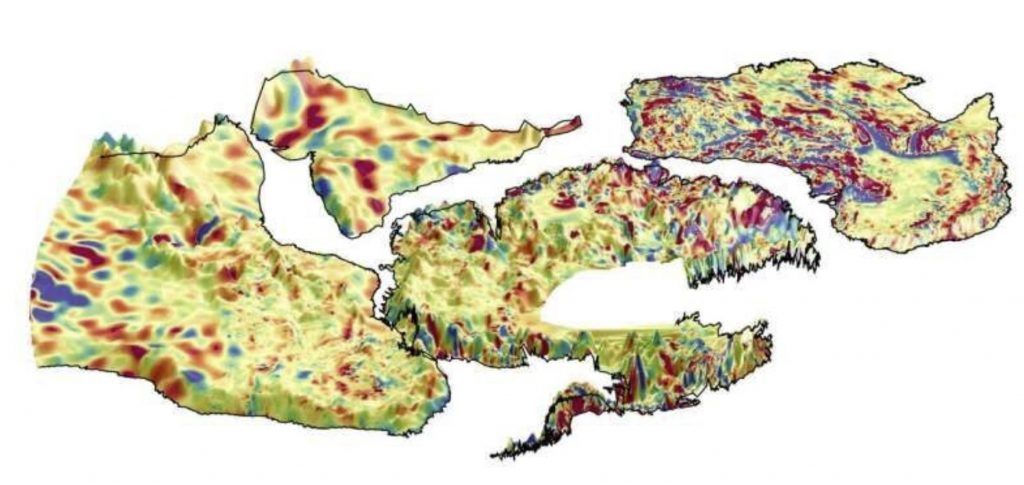
The team processed aeromagnetic data from aircraft from over southern Africa, Australia and Antarctica in a consistent manner with the help of Swarm satellite magnetic data.
Aeromagnetic data do not cover everywhere on Earth, so magnetic models complied from Swarm data help to fill the blanks, especially over India were aeromagnetic data are still not widely available. Furthermore, satellite data help to homogenize the airborne data, which were acquired over a period of more than 60 years with varying accuracy and resolution.
Jörg Ebbing, from Kiel University, explains, “With the available data, we only had pieces of the puzzle. Only when we put them together with satellite magnetic data, can we see the full picture.”
The resulting combined datasets provide a new tool for the international scientific community to study the cryptic sub-ice geology of Antarctica, including its influence on the overlying ice sheets.
Gondwana was an amalgam of continents that incorporated South America, Africa, Arabia, Madagascar, India, Australia, New Zealand and Antarctica.
As the tectonic plates collided in the Precambrian and early Cambrian times some 600-500 million years ago, they built huge mountain ranges comparable to the modern Himalayas and Alps.
This supercontinent started to breakup in the early Jurassic, about 180 million years ago, ultimately leaving Antarctica stranded and isolated at the South Pole, and covered in ice for around 34 million years.
Now learn where did you live on Pangea…
Swarm is ESA’s first Earth observation constellation of satellites.
“Using the new magnetic data, our animation illustrates how the tectonic plates have moved over millions of years after the breakup of Gondwana,” explains Peter Haas, Ph.D. student at Kiel University.
Fausto Ferraccioli, Director of Geophysics at the National Institute of Oceanography and Applied Geophysics in Italy, and also affiliated with the British Antarctic Survey, said, “We have been trying to piece together the connections between Antarctica and other continents for decades. We knew that magnetic data play a pivotal role because one can peer beneath the thick Antarctic ice sheet to help extrapolate the geology exposed along the coast into the continent interior.
“But now we can do much better. With the satellite and aeromagnetic data combined, we can look down deeper into the crust. Together with tectonic plate reconstructions, we can start building tantalizing new magnetic views of the crust to help connect geological and geophysical studies in widely separated continents. Ancient cratons and orogens in Africa, India, Australia and East Antarctica are now better connected magnetically than ever before.” [Nature, Phys]
Now subscribe to this blog to get more amazing news curated just for you right in your inbox on a daily basis (here an example of our new newsletter).
You can also follow us on Facebook and/ or Twitter. And, by the way you can also make a donation through Paypal. Thank you!


Yes, but what is beyond Antarctica? Why are you and I forbidden to travel “across” the so called “continent”?
I spent 3 months in Antarctica for science. We traveled from Pine island Bay (where thay say it is currently melting at unprecedented rate’) to the Antarctica Peninsula… In Pine Island Bay we were stuck 1 week in deep ice that even our ice breaker wasn’t able to crunch…
In Antarctica, continental Glaciers are extremely slow moving thick ice sheets that cover part of a continent. Ice forms a dome in the centre of the continent and extremely slowly moves down towards the edges of the ice sheet. As the ice enters the sea (it is continuously moving into the sea as I said), there is a moment when the forces acting on the ice are too big and a giant chunk of ice breaks up…
Ocean water but also hydrothermal heat and to a lesser extent under-ice volcanoes are responsible for the faster crackling of giant icebergs in the Pine Island Bay area… There have always been some icebergs forming… And they always going to be icebergs that will form there…
What would be interesting to know if is the ice thinning on the Antarctic continent (flow rate > ice formation rate)… Since when?
There are only ‘scientific’ military bases over there. I visited 4 of them, because we delivered them some food and other basic products… Conditions are extreme… There’s not much you can control over there…
I wonder if they can map out the tunnels to those hidden chambers where they stashed the UFOs?
We will never know.