Cold temperatures aren’t too unusual in the latter half of spring, but April snow falling as far south as Oklahoma isn’t all that common.
A thin blanket of snow covered budding trees in communities across the midwestern United States on Tuesday as a strong cold front brought the region unusually wintry conditions for this late into the spring season. While the snow was mostly conversational instead of disruptive, the freezing temperatures that follow behind the front could pose a threat to gardens and crops alike.
An upper-level trough dipping over the Great Lakes is responsible for the belated touch of winter spreading across much of the country this week. The cold front producing the snow and ushering in the cold air extends off of a low-pressure system up in southern Quebec.
Snow fell as far south as Tulsa, Oklahoma, on Tuesday afternoon as the front moved through the region.
The latest measurable snow (at least 0.1 inches) on record in Tulsa, Oklahoma, resulted in an accumulation of nearly two inches on April 12, 1957. Springfield, Missouri, saw its latest accumulating snow just a few years ago, recording 1.4 inches of snow on May 3, 2013. The date of the latest accumulating snow pushes later into the year the farther north you go, stretching into May in cities like Milwaukee, Wisconsin, and Buffalo, New York.
The National Weather Service expected a “slushy” couple of inches of snow from northern Illinois to western New York, and winter weather alerts are in place for southern Ontario where the Greater Toronto Area could see a dusting of snow by the end of the precipitation.
While the snow could make travel a bit difficult if it briefly covers roadways, it’s tough for snow to accumulate when it’s this deep into the spring. The high angle of the sun in the late April sky allows solar radiation to easily penetrate the cloud cover, heating up surfaces like sidewalks and roadways and forcing freshly fallen snow to melt, even if it’s cold enough for snow to stick.
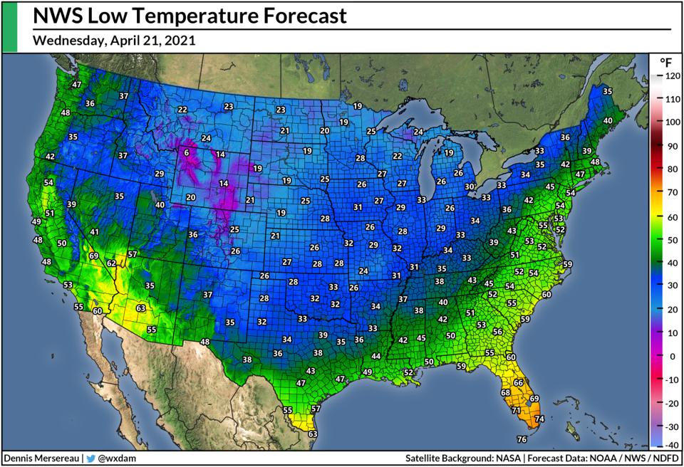
Freeze warnings cover a huge swath of the central United States, stretching from northwestern Texas to eastern Michigan, warning residents that near-freezing or sub-freezing temperatures could harm tender plants that are sensitive to the cold.
Forecasters expect low temperatures on Wednesday morning to reach the freezing mark deep into north-central Texas, with lows dipping into the 20s across most of the central Plains and Midwest. Chilly conditions will follow the cold front to the eastern seaboard, bringing near-freezing temperatures as far south as North Carolina’s Piedmont by Thursday morning.
In addition to the chilly temperatures and brief bout of snow, dry air will reach the Gulf of Mexico by Thursday, covering almost the entire country in low humidity—an impressive feat when humidity is a way of life in the southern states by this point in the season. [Forbes]
Now subscribe to this blog to get more amazing news curated just for you right in your inbox on a daily basis (here an example of our new newsletter).
You can also follow us on Facebook and/ or Twitter. And, by the way you can also make a donation through Paypal. Thank you!
You should really subscribe to QFiles. You will get very interesting information about strange events around the world.


We in Metcalfe County KY had Snow…well a very tiny amount BUT we had Snow!
North in Central KY they got 3″ of Snow!