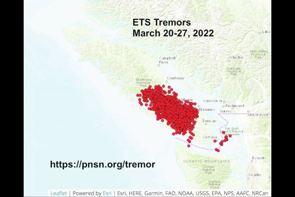
You can’t feel it, but the ground far beneath our feet on south-central Vancouver Island has been moving.
Seismologists have been recording thousands of “episodic tremor and slip events” occurring at a rapid rate since March 20 moving in a southeasterly direction down the Island.
More than 4,200 tiny tremors have been recorded so far between 25 and 40 kilometres below the surface, said John Cassidy, an earthquake seismologist with Natural Resources Canada and a professor at the University of Victoria.
“They’re not earthquakes. … On the instruments they look like series of a trains rolling by,” Cassidy said.
Preparedness: Protect your home and car with the best lightning and EMP protection available…
He said these bursts of small tremors and slips occur about every 15 months along faults that form the boundaries of tectonic plates — in our case, the Cascadia subduction zone from Brooks Peninsula on the Island to Northern California, where the Juan de Fuca plate system curves west beneath the North American plate.
The repeated episodes of slow fault slips — measuring about the size of five stacked dimes — usually occur over a period of several weeks, accompanied by tremors that appear on seismic records as prolonged, intermittent ground vibrations, Cassidy said.
The ETS activity has been going on for centuries, but has only recently been recorded using sophisticated GPS technology at more than 40 sites up and down the Island. They differ from earthquakes, which generate large, sharp shock waves that subside very quickly, but ETS can help in improving estimates on where and when the next earthquake might occur, Cassidy said.
By mapping out the areas on the subduction fault where stress is not accumulating over the long term, tremor events define the landward limit of the zone that could rupture during the next great earthquake.
That provides a more accurate estimate of how close the rupture could be to major West Coast cities such as Victoria, Vancouver and Seattle, and what shaking could occur, he said.
While tremor and slip events won’t help predict the timing of earthquakes, they do provide a basis for improved earthquake forecasting, says the Geological Survey of Canada.
Each ETS episode adds a small amount of stress to the locked portion of the subduction zone. As the stress increases and approaches a critical level, an ETS event may provide the additional stress needed to overcome the friction on a fault, triggering a great earthquake.
Preparedness: Use this filter to drink clean water at home!
“It helps us form an understanding of the subduction and where earthquakes are likely to occur and release energy … but where and how big we can’t predict,” Cassidy said.
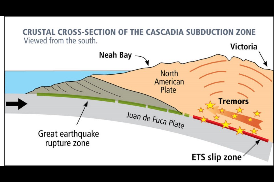
According to the Geological Survey of Canada, the Juan de Fuca and North American plates don’t slide easily past each other. They are held by friction in a locked zone, along the upper portion of the subduction fault, and occasional tremors cause slight slips, usually no more than a centimetre.
But every 500 to 600 years on average, the stress becomes too great in the locked zone and it finally ruptures, and centuries worth of accumulated energy is released, causing a magnitude-8 or -9 earthquake that results in 10 to 20 metres of fault movement, along the hundreds of kilometres that make up the Cascadia fault line.
After a great earthquake, the two plates lock together again and the stick-slip cycle is repeated.
According to the maps below, it seems that the slow slip event takes place along the entire Cascadia right now:
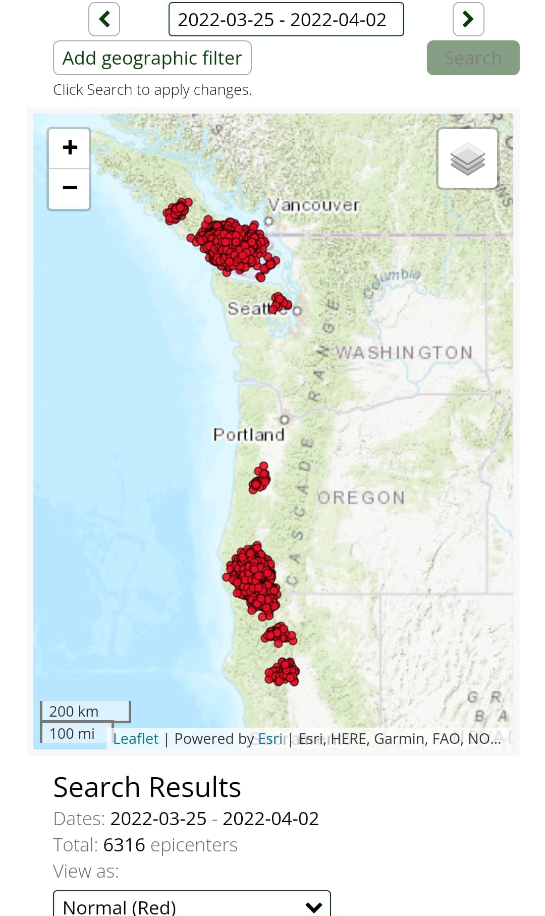
Find other maps in the Facebook post below:
Moreover, at least 3 earthquakes hit the Mendocino Triple Junction on April 4, 2022. This is where the Cascadia Subduction Zone meets the San Andreas Fault.

Although smaller earthquakes are common on and around the Island, the last “great earthquake” here was on Jan. 26, 1700. It measured between 8.7 and 9.2, Cassidy said.
He said the details are known because there is written history in Japan from that date of an “orphan tsunami” that rolled ashore that day, and it aligns with Indigenous oral history here of a tsunami and landslides.
Surveys of the coastline also show how land and forests slipped into the ocean, he said.
Since 1991, automated GPS instruments anchored into bedrock around the Island have been monitoring the gradual eastward squeezing of the coastal edge of southwestern British Columbia that results from the locked zone.
More recently, using improved GPS data and analysis tools, scientists discovered more subtle stick-slip behaviour in a deeper portion of the subduction fault, now referred to as the ETS slip zone.
Across the locked zone, extending down to depths of 15 to 20 kilometres, plate convergence has been pushing the coastal edge of the North American Plate inland for hundreds of years (as part of the great earthquake cycle). However, at depths between 25 and 45 kilometres, the subduction fault sticks for periods of about 15 months and then slips centimetres over a couple of weeks.
The slow fault slip and the tremors are so minute that they are only detectable with specialized equipment.
But they are important to note and could provide key information to seismologists on future quakes, said Cassidy.
Earthquakes usually need to have a magnitude 3 to be felt and magnitude 5 to cause damage, but it depends on where they occur, Cassidy said.
He said although it’s been 322 years since the last big one — which is safely within the 500- to 600- year average estimate — exact predictions on mega-thrust quakes (over magnitude 8) are impossible.
“It’s always a challenge not to frighten people, but we do live in an earthquake zone,” Cassidy said. “And it’s important to remind people to be prepared.” [Times Colonist]
StrangeSounds.org has been banned from AD NETWORKS! You can support me here…
The following links feature products I recommend you to add to your preparedness plan to help you and protect you during an emergency:
- Protect your home and car with the best lightning and EMP protection available…
- Get a satellite phone to communicate with your loved ones when internet and phones are down…
- According to a new report, about 50% of world’s water is ‘too polluted’ for swimming, fishing or drinking. Use this filter to drink clean water at home!
- Qfiles is another great site for alternative news and information…


Really would love the relief if in fact pressure is being released. How long do you suppose those little tremors need to release the pressure?
The time period for the quake has changed
They used to say every 300 to 400 years.
I personally think this may have something to do with some of the intraplate quakes we have.Slosh back effect of sorts.Then again I believe that magma is similar to the oceans in the respect that it has tides of a sort and slosh back
The key is to place sensors at depth.Problem is creating sensors that can stand that type of heat for long periods.They also need to be small enough to be practicle.
The hiss before the bite, the growl before the bark? You decide.
No, the exact opposite.
Umm, no. Nature always warns you but nobody is paying attention.
NO MOVEMENT FOR 100 YEARS is bad. Little tremors showing seismic pressure being released is GOOD. Relax.