A rare subtropical cyclone appears to have developed off the coast of Chile. Up to now, no subtropical or tropical cyclones have been recognized in that part of the world since cold water typically inhibits tropical development near South America. So was this strange phenomenon another amazingly rare weather event or some people playing ‘weather wizards’ off the Chilean coast?
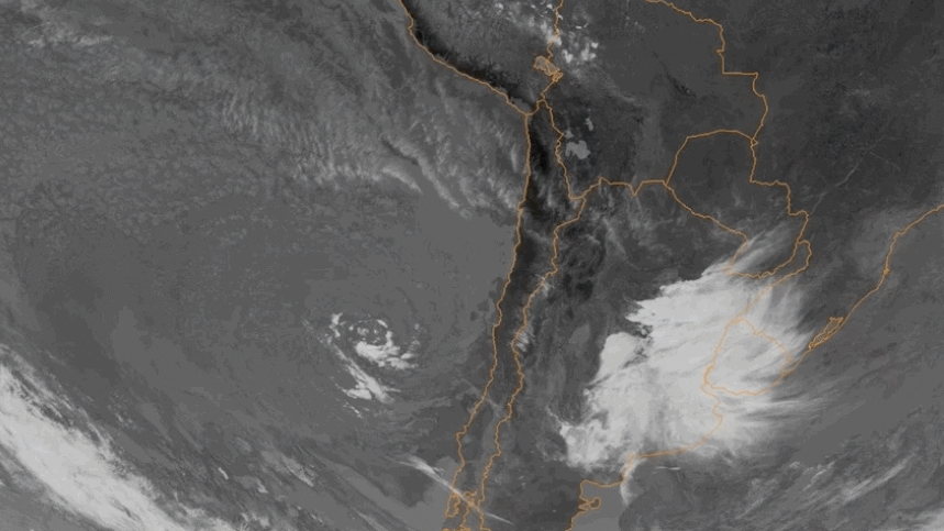
An exceptionally rare subtropical storm appears to have formed off the central coast of Chile in the southeast Pacific Ocean, typically one of the world’s most tropical cyclone devoid ocean basins. The subtropical cyclone formed late last weekend several hundred miles west of the South American coast.
The advanced scatterometer aboard the EUMETSAT satellite found the system had a well-defined surface low, with winds of 40-45 mph and shallow thunderstorm activity surrounding but not in its center Tuesday.
These ingredients define the system as a subtropical storm, a system with characteristics of both a conventional tropical cyclone and a colder, non-tropical low-pressure system you may see over land or water in the middle latitudes.
This system formed in water temperatures between 64 and 68 degrees, which is usually not supportive of sufficient thunderstorm activity that would help build a subtropical or tropical cyclone.
How is that possible then?
In this case, as with many subtropical cyclones of this nature, it had some atmospheric support. This cyclone is in the midst of an upper-level trough, or cold pool, of low pressure, adding the instability needed for thunderstorms.
This system is spinning clockwise, typical of any storm in the Southern Hemisphere, as both high-pressure and low-pressure systems spin in the opposite direction as they do in the Northern Hemisphere.
Interestingly, if there was a cyclone season in that part of the world, this system would have nearly fallen outside of it. A cyclone in the southern Pacific occurring in May is like a tropical storm occurring in November in the Atlantic. If there was a peak month for activity surrounding South America, it would be in February or March, so this system is quite late.
How Rare Is This?
It may be one of a kind. No other recognized subtropical or tropical storm has been documented in that part of the world. Unofficially, that is up to some debate. In 2015, a similar subtropical cyclone formed near Easter Island, which is located nearly 2,000 miles farther west of this week’s cyclone. Researchers called it Subtropical Storm Katie.

The southeast Pacific isn’t the only basin where some subtropical or even tropical cyclones go undeclared.
There are two reasons why we don’t see more subtropical or tropical storms in some ocean basins: Lack of responsibility and lack of good conditions.
There is no Regional Specialized Meteorological Centre (RSMC) specifically in charge of the southeast Pacific Ocean. On the opposite side of South America, in the south Atlantic Ocean, there have been several subtropical systems that have formed in recent years that have gone officially off the record.
In recent years, though, the Brazilian Navy Hydrographic Center has named such systems when they attain sustained wind speeds of 40 mph or greater. These systems are still largely off the record, and the record we do have is very short.
Similar subtropical systems have also occurred in the Mediterranean Sea between Europe and Africa. These systems are often called medicanes by meteorologists in the region despite their usual lack of hurricane force winds.
These systems are monitored by several countries in the region, which can lead to multiple names for a given system and some confusion. There is no RSMC that follows these so-called medicanes, but there has been an increasing amount of research on them. They have been known to do some damage and whip up dust across that part of the world.
The second reason few tropical or subtropical systems develop in the southeast Pacific Ocean is because atmospheric and oceanic conditions are far less hospitable than in the Atlantic or northern Pacific basins.
Water temperatures struggle to reach temperatures that help systems like this one blossom, even in El Niño, which helps water warm up in this region.
Wind shear is also typically higher across South America, which doesn’t allow for sturdy and tall tropical cyclones to develop.
Finally, there is a lack of atmospheric disturbances to kick the atmosphere into gear like in the Atlantic or Pacific. Compare this to the Atlantic where 40-70 tropical waves cross the Atlantic from Africa to Mexico each year.
Difference Between Tropical and Subtropical Depression/Storms
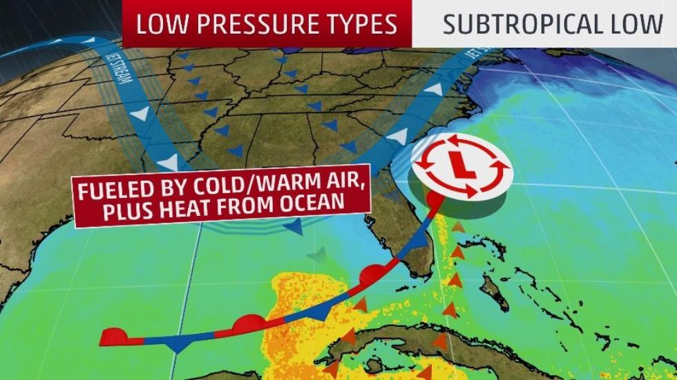
When an area of low pressure forms over waters with sea-surface temperatures of at least 70 degrees, a subtropical low can form. This is due to the core of the storm becoming warm, deriving some of its energy from latent heat, or energy released when water vapor that evaporated from the warm water is condensed into liquid.
A subtropical depression or storm exhibits features of both tropical and non-tropical systems. This includes no cold or warm fronts, a broad wind field and thunderstorms removed some distance from the center.
Subtropical systems also tend to have a large, cloud-free center and a less symmetric wind field. Maximum sustained winds are also much farther from the center, while the strongest winds in a tropical storm are close to the center.
Subtropical Low
Subtropical cyclones typically are associated with upper-level lows and have colder temperatures aloft, whereas tropical cyclones are completely warm-core and upper-level high-pressure systems overhead help facilitate their intensification.
The NHC still issues advisories and forecasts for subtropical depressions and storms. They are assigned a number or name, just like a tropical depression or storm.
Tropical low
If the subtropical storm remains over warm water, thunderstorms can build close enough to the center of circulation, and latent heat given off from the thunderstorms can warm the air enough to create a fully tropical storm.
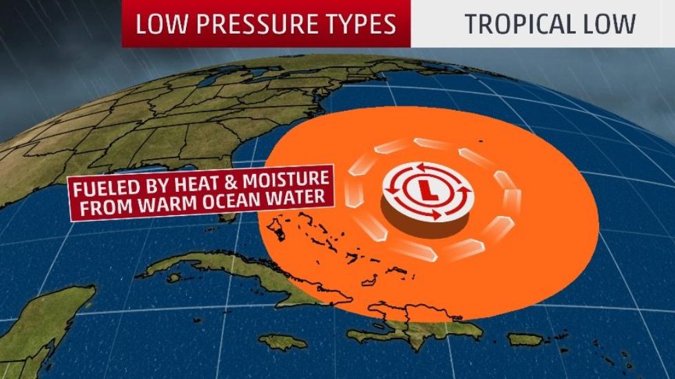
As a result, the strongest winds and rain become closer to the center and, with time, further intensification becomes possible.
So was this strange phenomenon another amazingly rare weather event or some people playing ‘weather wizards’ off the Chilean coast?
Follow us: Facebook and Twitter
Extremely Rare Southeast Pacific Subtropical Cyclone Forms Off the Chilean Coast – Weather.com


")


