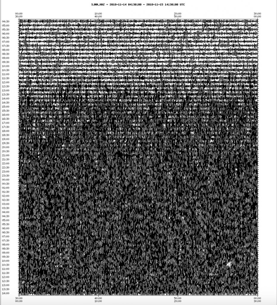
The effects of the incredibly strong low pressure system moving through Atlantic Canada caused more than ripples across the Atlantic Ocean this week, causing giant waves to track towards Europe and Africa. The LARGEST waves on the planet crashed onto the Grand Banks of Newfoundland with significant wave height over 15 metres (50 feet) and theoretical maximum wave height over 30 metres (100 feet) on November 14-15, 2018. Large swells and surf reached Ireland, Portugal, and parts of Africa this weekend. As the world’s largest waves, and wind gusts of more than 100 km/h hit Newfoundland, the island started shaking like during an earthquake. Just look at this image from a seismograph in St. John below… It was going crazy:

According to John Cassidy, a seismologist at the Department of Natural Resources of Canada, similar seismic activity is recorded at this time of the year when giant waves combined to high winds engulf the eastern and western coastal regions of Canada.
#Newfoundland shaking… As the world's largest waves, and wind gusts of more than 100 km/h hit Newfoundland, the island is shaking (well-recorded by #NRCan's seismic station at St. John's – plot shows the past 34 hours)#weatherhttps://t.co/Ozak3dFm8hhttps://t.co/FhWJ5JI3ni pic.twitter.com/AtwqyfM2YG
— John Cassidy (@earthquakeguy) November 15, 2018
This video recorded around 7:30 AM on the morning of November 15, 2018 in Bonavista, Newfoundland and Labrador shows the dramatic of the situation when such storms hit:
This is not the only place on Earth where seismographs record seismic activity during violent storms. For example, increased seismic activity was observed after Hurricane Irma passed Puerto Rico and the Dominican Republic giving the appearance of earthquakes:
Increased seismic activity observed after Hurricane #Irma passed Puerto Rico and the Dominican Republic giving the appearance of earthquakes pic.twitter.com/xoo5XEMWtD
— Baron (@BaronWeather) September 7, 2017
The Weather Network – Largest waves on the planet target Newfoundland, see it here


100 Km/h … 124 m/h
AT&T outage map
https://downdetector.com/status/att/map/
DO NOT TAKE VACCINES! Government uses vaccines in order to kill you!
CDC Admits 98 Million Americans Were Given Cancer Virus Via The Polio Shot
https://www.youtube.com/watch?v=WetrKjUBkR0
This happened on our Earth!!! 14-16 November 2018
https://www.youtube.com/watch?v=lBPNXg0KfE0&list=UU2vfhm1DVuJz_TIIxN-_oOg
The rock slide in a quarry looked very dynamic.
HUGE WAVE HITS THE COAST OF TENERIFE, SPAIN | Nov. 18, 2018
https://www.youtube.com/watch?v=Crx-IXdc-RI&index=1&list=UUXqiR3oMm0MlT06ms1o6z5A
END TIMES SIGNS LATEST STRANGE EVENTS (NOV 17, 2018) EXTREME WEATHER
https://www.youtube.com/watch?v=QuTCF5sMGEc&list=TLGGSkkPl4yS18ExODExMjAxOA
Thousands of rotten fish on a beach ruined a beach wedding in Florida.
https://www.youtube.com/watch?v=ioH4oKXZpZk
A storm can create shaking recorded in the seismogram. This is very interesting. I always check USGS Heliplots with seismograms all over the world. I always wonder why “US/ISCO Idaho Springs, Colorado, USA” gets always wavy seismogram? There is magma activity under Idaho Springs, Colorado?
Today’s USGS Heliplots. It looks like the Earth has just started shaking.
https://earthquake.usgs.gov/monitoring/operations/heliplot.php