After thunderstorms with damaging winds moved through portions of the Plains on Wednesday, meteorologists are monitoring some of the same areas for Thursday and Friday.
However, even more real estate will be at risk.

As a cold front slowly advances southward in the Plains and Midwest on Thursday, showers and thunderstorms will develop in the zone where the front meets the hot and humid air in place.
“Thunderstorms will continue to erupt across the north-central U.S. Thursday around the periphery of a sprawling dome of heat which continues to bake the central Plains,” explained AccuWeather Meteorologist Matt Benz.
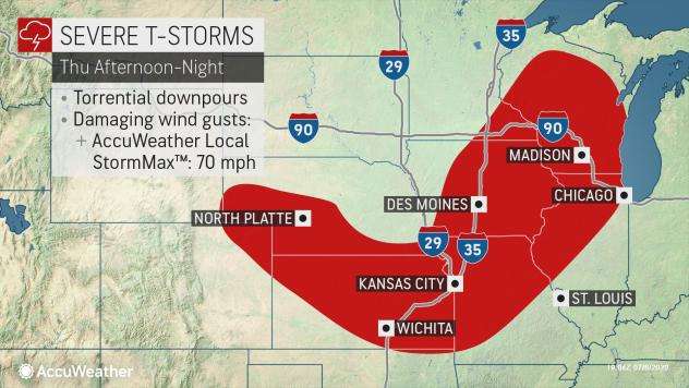
First wave of storms on Thursday
Storms moving through Minnesota and Wisconsin on Thursday morning are likely to move southward into portions of Iowa and western Illinois in a weakened fashion early Thursday afternoon.
However, with the heating of the day and the front in the area, the storms are likely to regain strength later in the afternoon.
These storms are likely to move eastward and could impact areas as far east as Chicago before weakening later Thursday night.
Second wave of storms on Thursday
A second area of storms is likely to develop late on Thursday afternoon in portions of western Nebraska and northeastern Colorado.
This cluster of thunderstorms is expected to grow in size and move southward into Kansas.
These storms may then combine with an area of thunderstorms developing overnight in southern Kansas.
Unlike the thunderstorms farther north and east, the storms in the Plains will likely continue through much of the night.
The two waves have similar threats: Damaging wind (up to 70 mph forecast) and torrential downpours, leading to localized flooding.
Friday’s storms
On Friday, the threat is largely expected in locations farther north and west. Cities such as Bismarck, North Dakota, and Rapid City and Pierre, South Dakota, will be at risk of experiencing thunderstorms. In addition, these storms may present more hazards than the storms on Thursday.
A cold front will move into the northern High Plains on Friday. As an area of low pressure develops along the front, this will further aid in thunderstorm development.
Initially, thunderstorms are expected in an isolated nature in eastern Montana during the early afternoon hours. When the storms first form, a threat for hail will exist, some of which could be large.
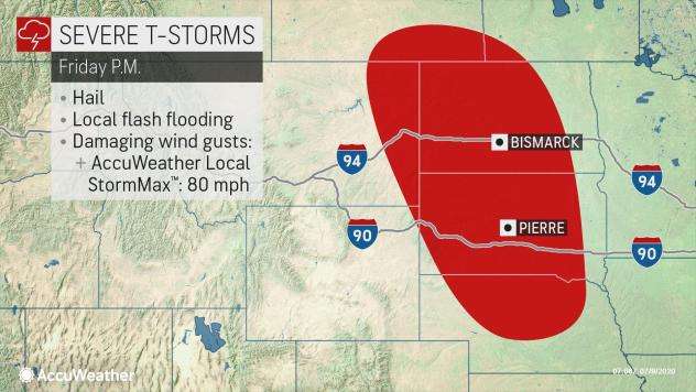
As the thunderstorms expand in coverage, a line is expected to develop and move across the Dakotas during the later afternoon and evening hours.
At that point, localized flash flooding and damaging winds gusts of up to 80 mph will become the primary threats.
Later Friday night, the storms are likely to turn southward into Nebraska. A severe threat may develop from Nebraska southward into Kansas and Oklahoma on Saturday.
More weather news on Strange Sounds and Steve Quayle. Now if you are looking for supplements to increase your healthy lifestyle and sexlife please visit Natural Health Source. [AccuWeather]


