This Map Shows Where America Lives

0

This impressive US map shows the most densely populated areas in the United States. 80% of Americans live in metropolitan areas. American concentrate on the coasts leaving most of the inner country looking like a vast and empty prairie. I find this crazy!


this is where we live is an infographic showing where America lives, population numbers , infographic , population , United States, population density in us cities, usa are empty, us population lives in new york chicoga and los angeles, New Jersey is the denser populated state in usa, what is the densest population state in the us, usa is a vast prairie, us population grows, us population stays on west and east coast but is empty in the middle, time magazine infographic this is where we live


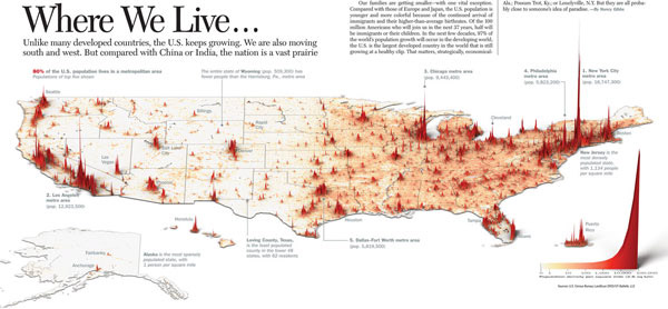
The five largest agglomerations are New York, Los Angeles, Chicago, Philadelphia and Dallas Fort Worth. Interestingly, these zones aren’t the safest as shown here.

Important: To learn some more, click on the map!

Follow us: Facebook and Twitter

Leave a reply

Please enter your comment!
Please enter your name here

This site uses Akismet to reduce spam. Learn how your comment data is processed.