The World is Rumbling: Huge Alaskan Landslide Sets Off Earthquake Sensors Around the World

0

This rock fall is one of the largest natural landslides that occurred within the last few years. And this 68 MILLION ton rock fall has been located through seismic data gathered from around the world.

Mount La Perouse landslide, Mount La Perouse rock avalanche: more images, photos of Mount La Perouse rock avalanche, Mount La Perouse landslide news, Mount La Perouse landslide photo, photo of Mount La Perouse landslide, huge landslide in Alaska, Mount La Perouse landslide Alaska. Photo: landlide blog (AGU), Mount La Perouse after the landslide, Detecting very large landslides with seismic data, large landslide detection, seismic data to discover landslide location, locate landslide with seismic data,
Mount La Perouse landslide Alaska. Photo: Drake Olson

This landslide took place at Mount La Perouse in a remote area in southeastern Alaska on February 16 2014.

Here a before and after picture from NASA:

Mount La Perouse landslide, Mount La Perouse landslide february 2014, seismic data to locate huge landslide, NASA Mount La Perouse landslide Alaska before (left) and after (right) pictures, Mount La Perouse landslide Alaska before (left) and after (right) pictures, Mount La Perouse landslide Alaska before and after photo, photo of Mount La Perouse landslide Alaska before and after
Mount La Perouse landslide Alaska before (left) and after (right) pictures

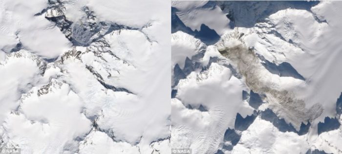
Debris from the landslide flowed 4.8 kilometers downhill and left deposits as deep as 40 feet-almost the height of a five-story building.

massive landslide Alaska 2014, huge landslide Alaska february 2014, huge landslide detected in Alaska with seismic record, how to locate huge landslide, seisimic helps to locate huge landslide in Alaska 2014, Huge Mount La Perouse rock avalanche Alaska - February 2014. Photo: Fly Drake
Huge Mount La Perouse rock avalanche Alaska – February 2014. Photo: Fly Drake

Large landslides in remote locations used to go unnoticed. A new remote sensing approach, based on seismic data, can reveal the time, force, direction, and speed of a large landslide. Unlike earthquakes, which release bursts of energy for a few seconds, landslides create sustained seismic readings that can last many minutes.

For more pictures and explanations follow this link here!

Follow us: Facebook and Twitter

Leave a reply

Please enter your comment!
Please enter your name here

This site uses Akismet to reduce spam. Learn how your comment data is processed.