On Saturday, it was just an ordinary tropical storm sweeping through the Pacific Ocean.
But in a day’s time, the storm named Noru exploded – becoming a super typhoon and the planet’s most intense storm of the year so far.
In a mere 18 hours, Noru’s peak winds increased by 90 mph. What a major, major change!
Here is a satellite animation showing it change from a tropical storm to a Super Typhoon with storm’s peak windsof at least 150 mph:
rapid intensification of now Super Typhoon #Noru, latest JTWC guidance has winds 140 g 170 kt — via about 36 hrs of #Himawari enhanced IR pic.twitter.com/dURt5kBqDw
— NWS OPC (@NWSOPC) July 30, 2017
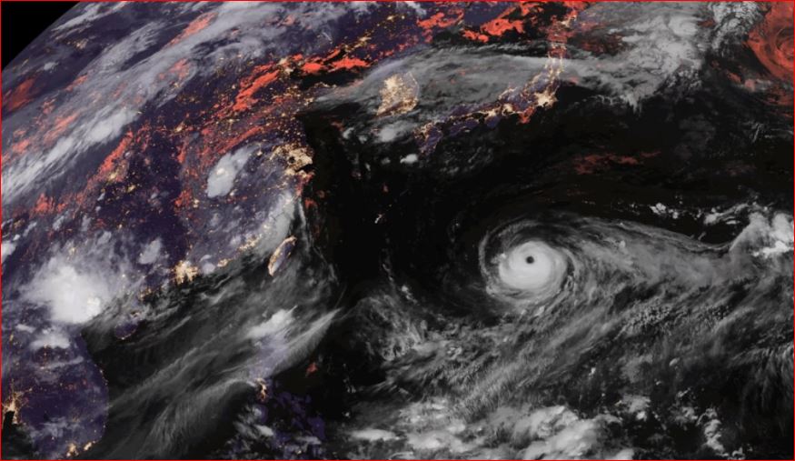
From a somewhat ragged swirl, Noru became almost perfectly circular and symmetric — flaunting an unmistakable eye.
Once it neared and reached peak intensity late Sunday, boasting maximum sustained winds of 160 mph – equivalent to a Category 5 hurricane – the images were jaw-dropping:
#Noru exploded into Cat 5 super typhoon & starting to turn northerly towards #Japan but expected to weaken en route. Track still uncertain. pic.twitter.com/Mzlb4k9LeS
— UW-Madison CIMSS (@UWCIMSS) July 30, 2017
Here’s a close-up inside the eye of Noru, revealing small swirls known as mesovortices:
On 7/30, Himawari-8 captured this imagery of Typhoon #Noru, w/ its 140 mph winds, spinning in the W. Pacific. https://t.co/NRUy68BLnY pic.twitter.com/eprRSOM7QY
— NOAA Satellites (@NOAASatellites) July 31, 2017
Noru, which meandered in the Pacific for 10 days before it turned into a Super Typhoon, weakened slightly Monday. The Joint Typhoon Warning Center said its maximum sustained winds had fallen to about 145 mph — the equivalent of a Category 4 hurricane. Slow weakening is forecast over the next 36 hours. The storm could threaten Japan in about a week.


