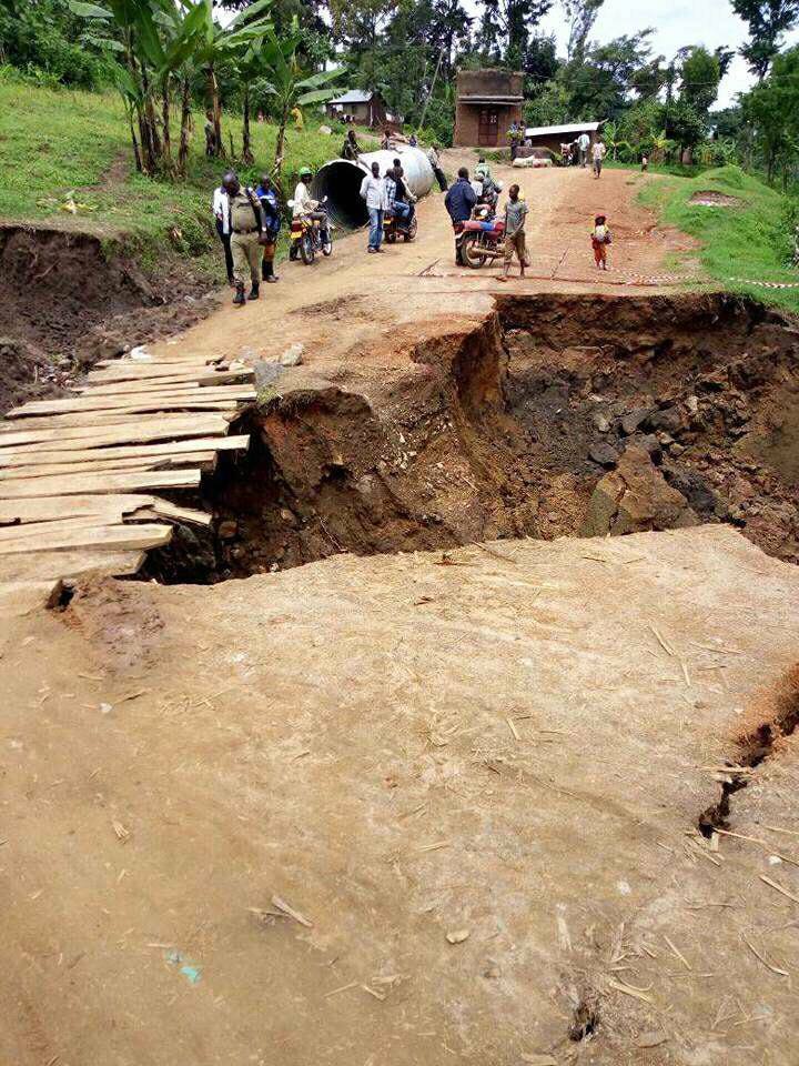
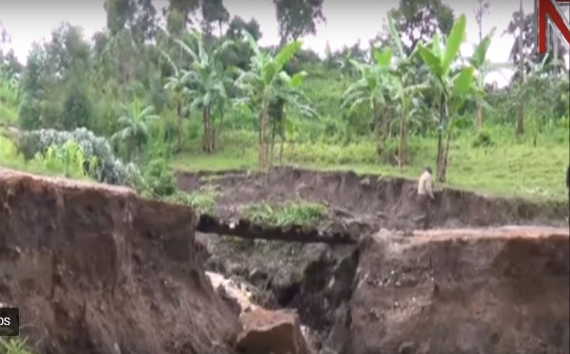
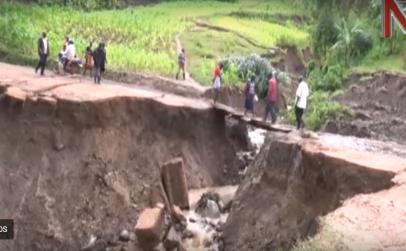
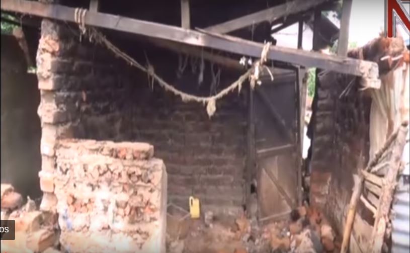
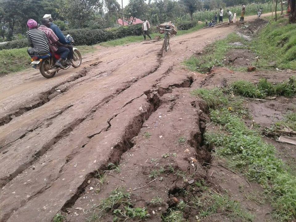
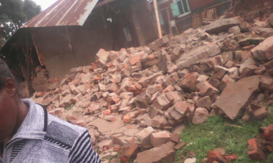
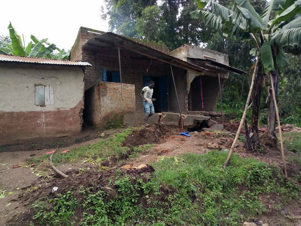
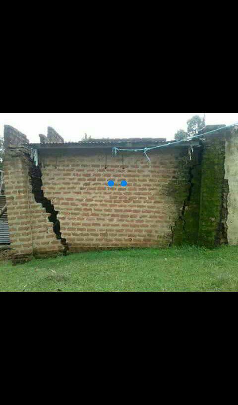
Over 300 homes have been destroyed and several people displaced after several big cracks developed following heavy rain in Bupoto Sub County and Namisindwa town council in Namisindwa district, Uganda on May 23, 2018. The fissures in the ground go right through people’s houses, gardens and bridges have been washed away. Like Kenya, Uganda is situated in the valley of the East African Rift, which is in the process of splitting the African Plate into two new separate plates – the Nubian Plate and the Somali Plate. After giant cracks opened up in Kenya, now Uganda has its own cracks. Something big is happening in the region right now! Just to say…
Here some more pictures of the dramatic situation… As if an earthquake had just struck the area:
The Great Rift Valley is a name given to the continuous geographic trench, approximately 6,000 kilometres (3,700 mi) in length, that runs from Lebanon’s Beqaa Valley in Asia to Mozambique in Southeastern Africa.
Today, the term is most often used to refer to the valley of the East African Rift, the divergent plate boundary which extends from the Afar Triple Junction southward across eastern Africa, and is in the process of splitting the African Plate into two new separate plates.
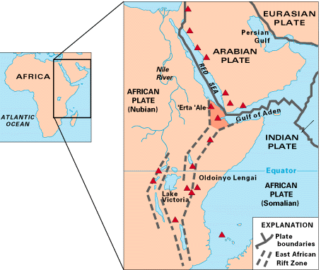
Geologists generally refer to these incipient plates as the Nubian Plate and the Somali Plate.
The East African rift has two branches, the Western Rift Valley and the Eastern Rift Valley.
The Western Rift, also called the Albertine Rift, is bordered by some of the highest mountains in Africa, including the Virunga Mountains, Mitumba Mountains, and Ruwenzori Range. It contains the Rift Valley lakes, which include some of the deepest lakes in the world (up to 1,470 metres (4,820 ft) deep at Lake Tanganyika).
Much of this area lies within the boundaries of national parks such as Virunga National Park in the Democratic Republic of Congo, Rwenzori National Park and Queen Elizabeth National Park in Uganda, and Volcanoes National Park in Rwanda. Lake Victoria is considered to be part of the rift valley system although it actually lies between the two branches. All of the African Great Lakes were formed as the result of the rift, and most lie within its rift valley.
In Kenya, the valley is deepest to the north of Nairobi. As the lakes in the Eastern Rift have no outlet to the sea and tend to be shallow, they have a high mineral content as the evaporation of water leaves the salts behind.
For example, Lake Magadi has high concentrations of soda (sodium carbonate) and Lake Elmenteita, Lake Bogoria, and Lake Nakuru are all strongly alkaline, while the freshwater springs supplying Lake Naivasha are essential to support its current biological variety.
The southern section of the Rift Valley includes Lake Malawi, the third-deepest freshwater body in the world, reaching 706 metres (2,316 ft) in depth and separating the Nyassa plateau of Northern Mozambique from Malawi; it ends in the Zambezi valley.
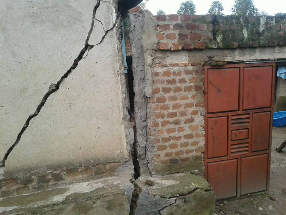
The African continent is splitting in two. First cracks opened up in Kenya. Now fissures spread to Uganda. Something big is going on in the African Great Rift Valley… Just to say.
Follow us: Facebook and Twitter
Heavy rains destroy 300 homes in Namisindwa district – NTV Uganda


")


[…] 2018/5/26 在乌干达,巨大的裂缝摧毁了300多所房屋,并迅速疏散了数十人。 […]
[…] Over 300 homes have been destroyed and several people displaced after several big cracks developed following heavy rain in Bupoto Sub County and Namisindwa town council in Namisindwa district, Uganda on May 23, 2018. The fissures in the ground go right through people’s houses, gardens and bridges have been washed away. Like Kenya, Uganda is situated in the valley of the East African Rift, which is in the process of splitting the African Plate into two new separate plates – the Nubian Plate and the Somali Plate. After giant cracks opened up in Kenya, now Uganda has its own cracks. Something big is happening in the region right now! Just to say… more […]
There was a tremor very close to Oak Ridge National Laboratory & K-25 Gaseous Diffusion Plant. M2.7 tremor with coordinates 35.872°N 84.297°W.
“K-25 was the code-name given by the Manhattan Project to the program to produce enriched uranium for atomic bombs using the gaseous diffusion method. ”
Those suspicious and secret project facilities have also the reptilian secret underground bases under them. The tremor was caused by the demolition activities of Galactic Federation of Light.
[…] post After Kenya, now Uganda: Giant cracks destroy over 300 houses and prompt evacuation of dozens of res… appeared first on STRANGE SOUNDS – AMAZING, WEIRD AND ODD […]