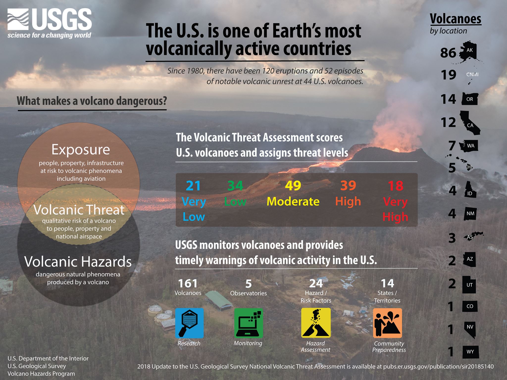
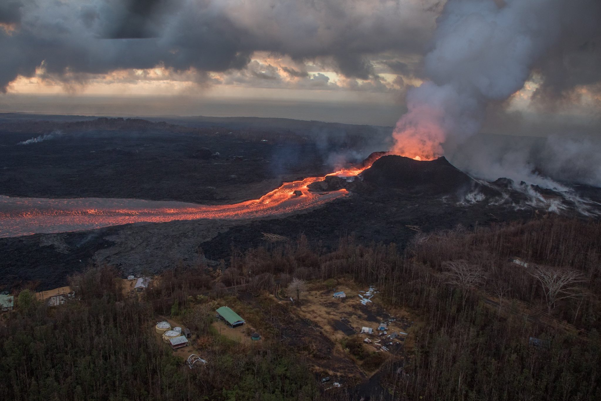
Since 1980, there have been 120 eruptions and 52 episodes of notable volcanic unrest at 44 U.S. volcanoes. When erupting, all volcanoes pose a degree of risk to people and infrastructure. However, the risks are not equivalent from one volcano to another because of differences in eruptive style and geographic location.
So how do we make choices on where to build or strengthen volcano monitoring networks and where more work is needed on emergency preparedness and response?
This newly published 2018 update to the USGS National Volcanic Threat Assessment helps guide decision-making and prioritization.
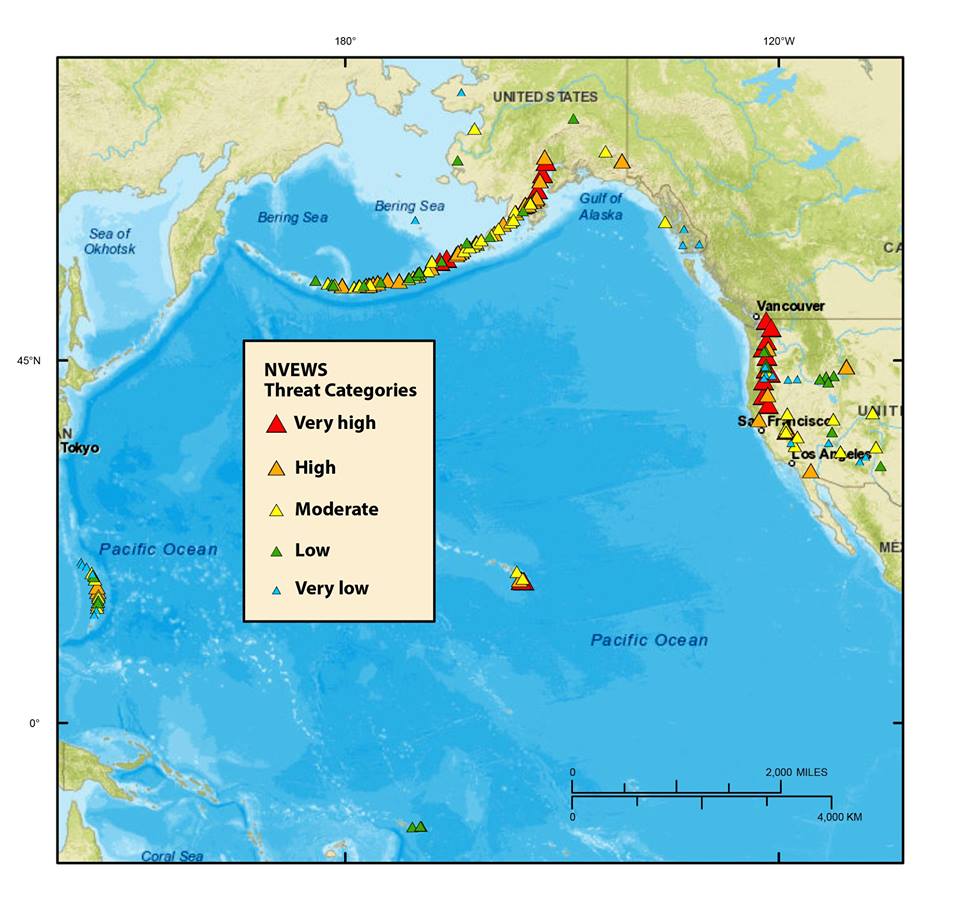
The assessment focuses on the active and potentially active volcanoes in the U.S., analyzing their histories, hazards and the exposure of people, property and infrastructure to harm during the next eruption. The assessment uses 24 hazard and exposure factors to derive a score and volcanoes are grouped into five threat categories.
The update names 18 very high threat, 39 high threat, 49 moderate threat, 34 low threat, and 21 very low threat volcanoes. The volcanoes are in Alaska, Arizona, California, Colorado, Hawaii, Idaho, Nevada, New Mexico, Oregon, Utah, Washington, Wyoming, American Samoa and the Commonwealth of the Northern Mariana Islands. The threat ranking is not a list of which volcano will erupt next. Rather, it indicates how severe the impacts might be from future eruptions at any given volcano.
The updates makes several changes to the 2005 assessment based upon (1) new age dates for volcanic products, and (2) updates to the hazard and exposure factors. As a result, some volcanoes were added or removed, and the threat ranking changed for others.

The volcanic threat assessment helps prioritize U.S. volcanoes for research, hazard assessment, emergency planning, and volcano monitoring.
The next big eruption could happen around your corner. Be ready or get prepared!
Follow us: Facebook and Twitter or become a Patron on Patreon / donate through Paypal. Please and thank you.
USGS – 2018 update to the U.S. Geological Survey national volcanic threat assessment


Excellent Post, and EXCELLENT comment “Truth”…SO GLAD ~ others are awake to what is happening…For all others…Do not be deceived by paid shills trying too silence the truth…Those that are awake keep spreading this information…It is vital we wake as many as we can to the truth…
Would you like some proof…?
Here is an author from one of the first truth sites back in the late 90’s…He was contacted by two of the military men working North of Fairbanks, Alaska when they began testing their first PURE EVIL HAARP weapon…They bought the author round trip tickets too come to Alaska and see first hand ~the weapon (a one mile square site of these weaponized ionospheric heaters) ~ and the physically altered babies of the remote Alaskan village, and stories of how native people were being KILLED by events dubbed as “BURNING SKY”….The author SEEN the evidence first hand, came back and reported on the story…And was CONSEQUENTLY contacted, THREATENED by the National Security Agency…It was effective…Because one of the sisters of the two men who paid for his ticket, and the author stayed with her, was MURDERED outside Fairbanks…He was given a handler, and BOUGHT OFF and let the story die…Do not take my word for it…Read it in his own words…Free book and I tell you what, once you start it, you will not put it down until it is finished…Quick Read….—->http://www.viewzone.com/menelik2.html
This was the site he visited, and NO it is not the TINY itty bitty one EVERYONE was DUPED into seeing…
—>http://pfrr.alaska.edu/
And here is a map of the MANY ~ MANY ~ MANY sites they now have…—-> http://climateviewer.org/pollution-and-privacy/atmospheric-sensors-and-emf-sites/maps/haarp-ionospheric-heaters-worldwide/
Do some digging around in that last site, as there is a TON of fantastic info available there….
ALSO~ they just upgraded Yellowstone too HIGH ERUPTION ALERT..~!~!~! —-> https://buckrail.com/government-scientists-just-raised-the-threat-level-for-yellowstone-eruption-to-high/
He knows nothing abiut HAARP technology or he is a shill to silence truth which i am sure that he is.
The US is the storm making masters of the world using haarp, nexrad radar and coal powered powerplants for cloud seeding the storms then steering them by altering the jetstream to their designated location or country to cause major destruction and loss of life and property along with destruction of crops and food all controlled by zionist and Israelies with dual citizenship in the US.
The head of the National weather service is one of these people, they run the news media, hoolywood, disney, our banking(FEd) and wallstreet which is why no ine went ro jail over the crash in 2008-2009, they run Ameruka
Contrary to sleeping through every possible danger, like Rumplestiltskin, many of us like to be aware. Since my family resides near volcanos, we appreciate being aware of assessments by those more informed than we.
Must you people drag this idiocy out every week. There is nothing we can do about Earth Quakes you morons, so why do you constantly feel it is necessary to throw this in our faces week after week, except, all we can imagine is that it is a slow news day and you have nothing else to report.
If it isn’t this site it is another which are constantly pushing this crap. HOW’S THIS; WE DON’T CARE ! WE ARE NOT GOING TO GET ALL HYSTERICAL BECAUSE SOME SCIENTIST NEEDS TO GIVE THE IMPRESSION THAT HE IS EARNING HIS KEEP !!!
With a name like that, who can take your uninformed and ridiculous rant seriously?
Go back to sleep!
The name okay okay.
But the picture ! thats cool