Good morning, everyone: as I’m sure you’ve spotted by now, there was a magnitude 7.1 earthquake in Southern California at 2019 hours local time on Friday.
Although there are currently no reports of any deaths, the quake – which struck pretty much where the magnitude 6.4 quake took place on Thursday, near Ridgecrest – has caused gas leaks, structural damage and minor injuries in those in towns and cities nearby. Here’s everything you need to know about the quake:
So, what happened?
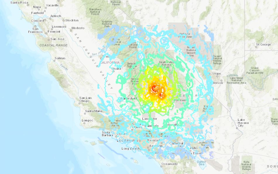
The powerful M7.1 quake struck just a stone’s throw away from the Independence Day strong and shallow M6.4 quake, at a depth of around 17 kilometres (10.6 miles or so), a little north-northeast of Ridgecrest in the Searles Valley.
According to the modified Mercalli scale, which measures shaking intensity, the quake, at its epicentre, came in as a IX on a scale that goes up to and theoretically past an X. That means the perceived shaking at the epicentre could be described as “violent”.
For those nearest the epicentre, this would have been a truly terrifying experience. The shaking in places like Los Angeles and Las Vegas would have been relatively weak, but still detectable, based on the 37,000 reports on the USGS website, with some coming in over in neighbouring Nevada, and even as far south as Mexico.
As this quake took place on land and far from any major body of water, there was no risk of a tsunami occurring.
What about damage or deaths?
According to the modified Mercalli scale, the potential for damage was “heavy,” and sadly, that appears to be materialising.
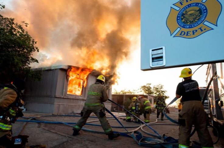
Several news outlets are reporting that power has gone out across large swaths of Ridgecrest, and there are gas leaks, fires, and injuries – but, fortunately, no deaths at present. Various fire departments – from those in Kern County to those in San Bernardino – are all responding to similar events, noting that in some cases they have evacuated residents while gas leaks are attended to, and from some homes that look structurally dicey.
#Earthquake(Update): Numerous gas leaks have been detected in the Trona and Argus areas. Firefighters have secured leaks where possible and evacuated residents from homes with leaks that cannot be secured. #SBCountyOES, #CERT, #ECS teams activated.
— SB County Fire (@SBCOUNTYFIRE) July 6, 2019
As before, the epicentre was some distance away from any town or city centre, with Ridegcrest being the closest, just a few miles down the road. That means the potential for damage was limited compared to any similar-scale even that might have took place right beneath or adjacent to a metropolitan area, but clearly, thanks to the intense and widespread shaking, widespread damage still occurred.
The USGS has a system that estimates the number of potential fatalities when a quake strikes. At the time of writing, there is a 65% chance that one or fewer people died, which is obviously great news – but there is also a 30% chance that up to 10 people perished. So far, thankfully, nothing of the sort has been reported.
This same system as estimates economic damage. There is a 33% chance that it caused anywhere between $100 million and $1 billion of damages, with a 31% chance that could run up to $10 billion. As ever, let’s hope the final number lands on the lower end of the spectrum.
Is this the mainshock? What about aftershocks?
The mainshock is the most powerful (highest magnitude) quake in the sequence – earthquakes happen as part of sequences, never in isolation – while the foreshocks take place before the mainshock, and the aftershocks take place after that. Sounds simple, right? Well it’s not so clear cut, as these terms can only really be applied in retrospect.
Thursday’s magnitude 6.4 quake, at the time, was the largest in the sequence, bounded by some weaker foreshocks and plenty of fairly powerful aftershocks. However, as the United States Geological Survey (USGS) noted at the time, and as is pretty standard for earthquakes of this magnitude, there was a non-zero chance that one of the aftershocks could be more powerful than the ‘original’ mainshock. Specifically, in the seven days after the magnitude 6.4 event, there was a 9% chance that one of the aftershocks could be larger than a magnitude 6.4 event. There was also a 2% chance that it would be a magnitude 7 quake.
So what you’re looking at here is that 2%-ish chance actually happening. This isn’t unusual or strange, but what it does mean is that the magnitude 6.4 quake is now another foreshock, and the magnitude 7.1 event is the new mainshock.

What’s most likely to happen now is that you’ll get plenty of aftershocks with rapidly decreasing magnitude over the next few days and weeks, and even months. The USGS’ aftershock forecast, though, emphasises that there is a non-zero chance an even more powerful quake could occur on the same fault(s).
In the next seven days, there is a 3% chance that one of the aftershocks will be larger than a magnitude 7.1. That’s very small, but again, it’s non-zero. Other than that, if that doesn’t happen, there will be anywhere between 240 to 410 magnitude 3 or higher earthquakes near or at the epicentre of the magnitude 7.1 quake – all of which can be felt by people at the surface in the area. There have already been (at the time of writing) four magnitude 5-or-higher quakes in the region, which are powerful enough to cause damage.
Hopefully, there’ll just be weaker and weaker aftershocks at this point, but as ever, we should be prepared for the possibility that an even larger quake could take place. The sequence, which started a couple of days back, is continuing, and it still has the potential, small though it may be, to step up its game, so to speak.
As seismologist Lucy Jones said on social media:
Yes, we estimate that there's about a 1 in 10 chance that Searles Valley will see another M7. That is a 9 in 10 chance that tonight's M7.1 was the largest.
— Dr. Lucy Jones (@DrLucyJones) July 6, 2019
What caused the earthquake?
As indicated by the beach ball-like object on the USGS’ report, this took place on the same fault system that produced the July 4 quake.
This was a strike-slip event, which involves two geological blocks grinding against each other, side-by-side, as one moves (roughly speaking) horizontally in the opposite direction to the other. Thanks to the strike-slip motion of the tectonic boundary between the jostling Pacific and North American tectonic plates, plenty of faults in the region behave in this way.
It took place 150 kilometres (93 miles) away from the San Andreas fault and has nothing to do with that infamous geological feature. Seismologists can’t quite say exactly which fault the earthquakes are taking place on just yet – although they’re certainly working on it – but based on the pattern of quakes so far, it looks like they are happening on two small connected faults. They are technically known as conjugate faults, which means that they intersect (in this case, pretty much at right angles), which means the slippage on one directly impacts and induces slippage on the other.
And now a Mw7.1 #earthquake near Ridgecrest, California ! Also strike-slip.
— Robin Lacassin (@RLacassin) July 6, 2019
The July 4 Mw6.4 was thus a foreshock of a large event.
The M7.1 most likely ruptured the NW-SE fault strand (purple on map), conjugate to the main NE-SW striking rupture of M6.4 foreshock (in green). pic.twitter.com/pCByl8b9OL
Sounds like a pretty big magnitude earthquake to me. Is that bad?
The Independence Day magnitude 6.4 quake was a fairly big deal; it was the most powerful to rock Southern California since the magnitude 7.1 Hector Mine quake, which struck a marine base in 1999. The USGS quake report explains that the largest quake that took place in the last four decades right near the last few days’ tremblors was a magnitude 5.8 quake, back in September 1995 – which makes the current sequence more powerful, by far.
In fact, Friday’s earthquake was 11 times more energetic than the Independence Day event, because the moment magnitude scale isn’t linear. With a single-digit increase in magnitude, from a 6 to a 7, say, you are talking about 32 times more energy being released as the fault ruptures.
Although unquestionably destructive, it’s a huge relief these quakes aren’t taking place closer to metropolitan areas. Just take the January 1994 Northridge quake, a M6.7 that hit the San Fernando Valley region of Los Angeles. It may have been weaker than Friday’s quake, but largely thanks to its proximity to far more people and structures, more than 60 people died back then. Another 9,000 people were injured, and the area racked up several billions of dollars’ worth of infrastructural damage.
Crucially, magnitude isn’t the only thing that matters when it comes to earthquakes. As I’ve explained in far more detail here, plenty of factors play a role, including – but not limited to – how intense the shaking is, how deep the quake is, how quake-resilient the buildings are, how aware the public are regarding how best to respond to quakes, the sedimentology of the region, and if the quake can trigger secondary geological effects, from tsunamis to landslides to even the fluidization of the ground.
Tragically, we were rocked by a much bigger 7.1 earthquake in the same area as Thursday's 6.4, which 11 times more energy and has put people into more stress. Stay strong, California – we're all in this together. | @USGS Event Page: https://t.co/BuO1dRUsqI. pic.twitter.com/LWyOmefDWL
— SCEC (@SCEC) July 6, 2019
Is this related to the ‘big one’?
No, for several reasons. First, there is no technical definition of what the big one is, and it means different-ish things and involves entirely different tectonic settings and faults to, say, people up in the Cascadia Subduction Zone in North California and northwards, compared to those in Central and Southern California.
In terms of the region currently wondering what exactly was going on beneath its feet, the ‘big one’ generally refers to a cataclysmic rupture somewhere along the San Andreas fault, which is a little over 1,280 kilometres (800 miles) long, and has plenty of smaller faults shooting off from it. This, sadly, is inevitable, but it’s impossible for anyone to say when and where exactly this will take place, and how powerful it will be.
Physical and mathematical laws do allow seismologists to forecast the ‘big one’, though, using wide-ranging probabilities. All the available data means that there is a 31% chance a magnitude 7.5 event will take place in the Los Angeles region within the next 30 years, with that rising to a 46% chance for a magnitude 7. For a magnitude 6.7 quake, it’s 60 percent.
For the San Francisco Bay area, within the same three decades, there is a 20% chance of a magnitude 7.5 tremblor occurring, which jumps to 51% chance if it’s a magnitude 7 quake and to 72 percent if it’s a magnitude 6.7 tremblor.
The big one will be any powerful enough quake to sufficiently damage one of these cities and cause a fair few deaths. Clearly, none of the quakes in the current sequence aren’t it, nor do they have any bearing on the eventual, bona fide ‘big one’.
Is this related to the Ring of Fire? Is the big one coming? Are we all doomed?
First and foremost, no, this isn’t connected to anything you’ve seen in the news that’s happening outside of Southern California. It has nothing to do with, for example, the paroxysm that took place earlier this week over at Stromboli, in Europe’s Tyrrhenian Sea. This isn’t a sign of the apocalypse or anything scarier, so if you see anyone claiming anything of the sort, they are either a liar or are, well, severely misguided.
The same applies to anyone who says they just know where the next big quake will occur, and how powerful it will be. Whatever they say will be – as it’s technically known – horseshit.
Dr. Lucy Jones, seismologist at California Institute of Technology and a former science adviser at the Geological Survey, says latest 7.1 magnitude earthquake will not trigger another earthquake outside Ridgecrest, CA, region. pic.twitter.com/5NX56ZOKD6
— MSNBC (@MSNBC) July 6, 2019
Sure, this quake took place along the horseshoe-shaped network of major tectonic boundaries known as the Ring of Fire, but that really doesn’t mean much. This loop, which surrounds much of the vast Pacific Ocean, is very complex, featuring constantly shifting, sliding and grinding plate boundaries, all with their own network of segregated or closely-spaced faults.
This continuous activity means that 75 percent of the world’s volcanoes and 90 percent of the world’s earthquakes take place along this boundary, with this latest sequence in Southern California just another day in the office for the Ring of Fire. Nothing out of the ordinary here. The more powerful a quake is, the rarer it tends to be, but this all fits in nicely with what scientists expect.
In some cases, an earthquake on one fault can trigger another on a different fault nearby, and it looks like these quakes do involve two faults that are essentially conjoined. However, as pointed out by Jones, this will not trigger quakes elsewhere in California or anywhere else around the country.
Quakes trigger other quakes nearby. no more than 3-4 times the length of their fault. A M7.0 might be able to trigger over 100 miles or so. No effect anywhere else. Alaska does not trigger California quakes and vice versa.
— Dr. Lucy Jones (@DrLucyJones) November 30, 2018
That sort of fault triggering only applies to faults that are no further away than three to four times the length of the fault that ruptured.
In other words, a magnitude 7 quake could potentially trigger another tremblor on a fault 160 kilometres (100 miles) away, but that’s not guaranteed. The only other quakes these rumbles could set off will be within the same Ridgecrest area.
As ever, there is no way in hell that these tremblors will set off any more quakes anywhere else along the Ring of Fire.
But what we can say is that within the last few days, California experienced the two largest quakes in 20 years. And that is kind of worrying!


Well with the full red moon is coming July 16 , we should have 6-8 in ring of fire is imminent till August 11
2019. California all faults are shaking from Sandi ego to Vancouver Canada so i do promise you it will happen a 7 greater in southern California. Please see quake 10 movie you can see fracking was causing a 10 in LAX area.
Still we see many fracking and it was a USA navy and air force base there, they may have had a new laser
beaming from sett-elites and testing for Iran war and final count down to World war 3?
Cause and Effect: http://m.drillfrackingnews.com/RidgecrestCaliforniafracking