Earthquakes and volcanoes are not random. They follow Earth’s tectonic architecture: where plates collide, separate, or grind past each other — and where old crustal scars inside plates get “reused” by modern stress.
This pillar is your master map: it explains the major global tectonic zones, why some produce both earthquakes and volcanoes, why others mostly quake, and where to file (and 301 redirect) “orphan” quake/eruption posts that don’t deserve their own standalone URL.
If you’ve ever asked: “Why did this earthquake happen here?” or “Why is this volcano active?” — this is the answer page.
TL;DR — Earthquakes and volcanoes in 60 Seconds
- Most earthquakes occur at plate boundaries.
- Most volcanoes also cluster at plate boundaries — but hotspots can build volcano chains inside plates.
- The biggest earthquakes happen at subduction zones (often tsunami-capable).
- Transform faults produce violent, shallow shaking (usually little to no volcanism).
- Rifts and spreading ridges quake often and can be intensely volcanic (Iceland is the headline land example).
- Collision belts build mountains and earthquakes; volcanism is limited and more regional.
- Intraplate quakes happen on ancient faults — rare, but surprising; intraplate volcanoes are mainly hotspot-driven.
The Big Picture: Earth’s Moving Plates (and why they erupt)
Earth’s crust is broken into tectonic plates that move only centimeters per year — slow motion with explosive consequences. Plates don’t glide smoothly. They stick, stress builds, and when friction loses… the crust snaps. That release is an earthquake.
Volcanoes enter the story when tectonics creates melt pathways:
- Subduction: water and sediments dragged down lower the melting point → magma rises.
- Rifting: the crust thins and hot mantle rises → decompression melting.
- Hotspots: deep mantle plumes feed volcano chains through plate interiors.
Key idea: the “where” is predictable. The “when” is not.
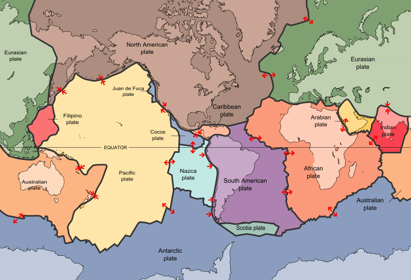
Map 1: The global “tectonic highways” (plate boundaries + motion)
Start here. The lines on this map are not decoration — they are Earth’s stress highways. Most earthquakes and many volcanoes cluster along these boundaries, because this is where the planet stores and releases tectonic strain (and opens magma pathways).
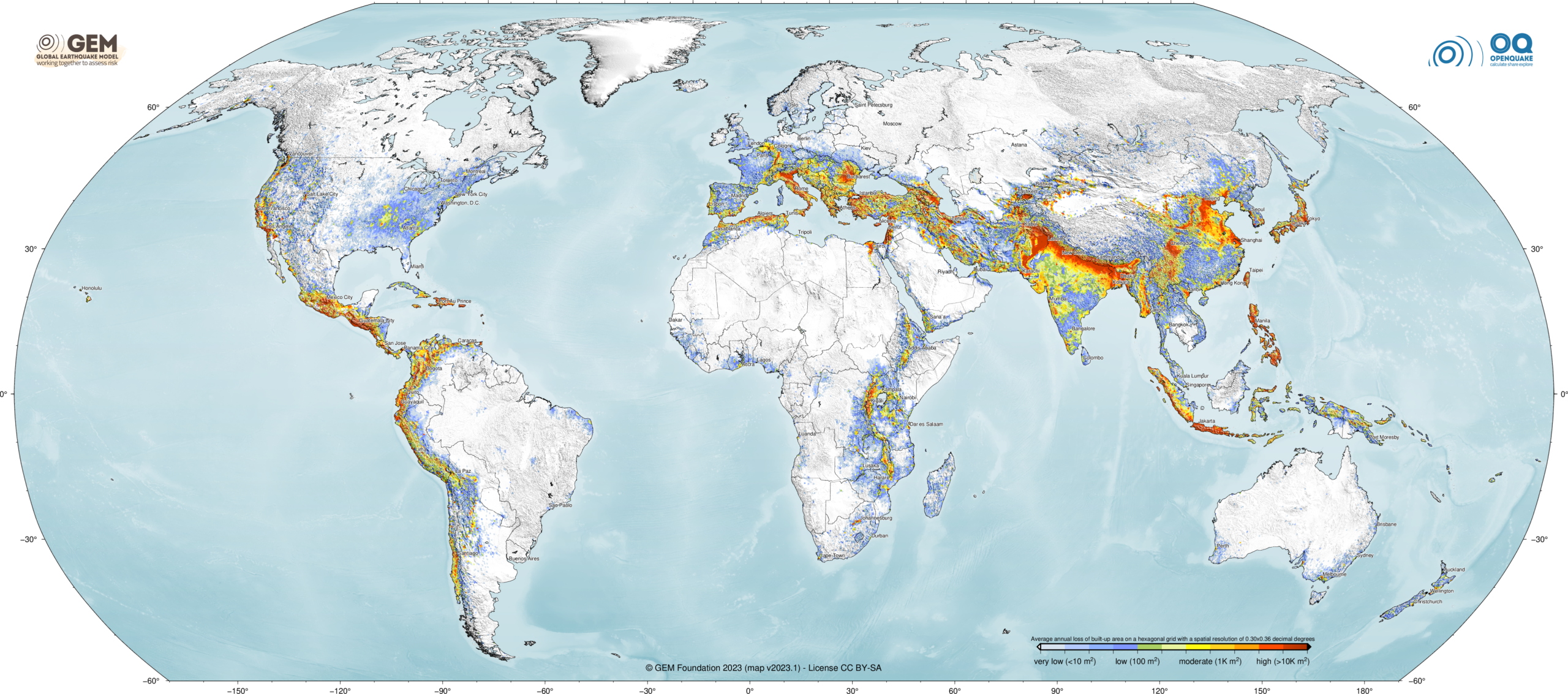
Map 2: Where the hazard becomes a human problem (risk + exposure)
Plate boundaries show where events happen. This map shows where earthquakes (and often volcanism) become a human problem — high hazard overlapping with exposure. Use it to explain why certain regions dominate disaster headlines.
The 6 Main Tectonic Zone Types (and what they do)
1) Subduction Zones – The biggest earthquakes + the volcanic arcs
Subduction zones form where one plate dives beneath another. They are the only places that reliably produce magnitude 8–9+ megathrust earthquakes — and many also build volcanic arcs (Japan, Andes, Cascades).
- Signature hazards: megathrust rupture, tsunami, long-duration shaking, aftershock sequences, explosive arc volcanism.
- Examples: Japan Trench, Cascadia, Chile–Peru Trench, Sumatra–Java, Alaska–Aleutians.
Explore your dedicated pillars:
Map 3: The world’s major subduction zones (the tsunami-capable belts)
Subduction is the planet’s biggest earthquake machine. The map below shows where oceanic plates are already diving under other plates — not just at the surface, but down to hundreds of kilometers depth. These “slabs” outline the belts that generate most M8–M9 megathrust earthquakes, major tsunamis, and many volcanic arcs.

Global map of subducted slabs (0–600 km): the same belts that drive the world’s biggest earthquakes, tsunamis, and many volcanic arcs.
Map 4: The Pacific Ring of Fire (the volcano + earthquake belt)
Here’s the visual summary: the Ring of Fire is what subduction looks like on a planet-wide scale. It explains why volcanoes and earthquakes cluster around the Pacific — and why “quiet” continents still get surprises via intraplate faults and hotspots.

The Pacific Ring of Fire marks where plates collide — Earth’s most active belt of earthquakes and volcanoes.
2) Transform Faults – Sliding plates, violent shallow shaking (usually no volcanoes)
Transform faults are where plates slide sideways past each other. They usually do not create the largest magnitudes — but they create some of the most destructive shallow shaking on Earth.
- Signature hazards: abrupt lateral rupture, strong near-field shaking, infrastructure damage.
- Volcanism: typically minimal (no major melt generation from sideways motion).
- Examples: San Andreas, North Anatolian Fault, Dead Sea Transform, Alpine Fault (NZ).
Explore your dedicated pillar:
3) Divergent Boundaries – Rifts & spreading ridges (earthquakes + basalt volcanism)
Divergent zones form where plates pull apart. Earthquakes are frequent (often smaller), and volcanism is common — especially on mid-ocean ridges.
- Signature hazards: swarms, fissure eruptions, rift earthquakes, ground cracking.
- Examples: Mid-Atlantic Ridge (Iceland), East African Rift, Red Sea rift system.
Explore your dedicated pillar:
4) Continental Collision Zones – Crumpling continents (big quakes, limited volcanism)
When continents collide, neither subducts easily. The crust thickens, fractures, and spreads seismic risk across wide belts. Volcanism is not the main feature here (though some regions have pockets of volcanism depending on older subduction or extension).
- Signature hazards: widespread shallow earthquakes across many faults; mountain building; landslides.
- Examples: Alps–Mediterranean, Zagros, Himalaya–Tibet, Caucasus.
Explore your dedicated pillar:
5) Hotspots – Volcano factories inside plates (sometimes seismic)
Hotspots are mantle-plume systems that punch through a plate far from boundaries. They are responsible for some of the world’s most iconic volcanic chains — and they can produce earthquake swarms when magma intrudes.
- Signature hazards: effusive eruptions, shield volcano growth, occasional explosive phases, magma-driven quakes.
- Examples: Hawaii; Canary Islands & Madeira hotspot chain.
Explore your dedicated pillars:
6) Intraplate Earthquakes – “Why here?” quakes inside plates
Intraplate earthquakes occur away from plate edges, often on ancient faults revived by modern stress. They’re less frequent — but they can be damaging because many regions are not built or prepared for them.
- Signature hazards: surprise, wide felt areas, weak preparedness, old faults “waking up.”
- Examples: central/eastern North America, parts of Australia, stable cratons with reactivated structures.
Explore your dedicated pillar:
Major Global Earthquake & Volcano Zones (your filing system)
Use this as your global filing system. If you don’t have a dedicated pillar for a region yet, redirect thin posts into the closest zone below and embed them as short context entries.
A) Pacific Ring of Fire (subduction + volcano factory)
- What it is: a belt of subduction zones surrounding the Pacific.
- What it produces: megathrust earthquakes, tsunamis, volcanic arcs.
- Best home pages:
B) Mediterranean–Anatolia–Alps (collision + transform chaos + regional volcanism)
- What it is: Africa pushing into Eurasia + microplates tearing and rotating.
- What it produces: destructive shallow quakes; subduction pockets and volcanic arcs (e.g., Aegean/Hellenic arc; Italy’s systems).
- Best home page: Mediterranean & Alpine Faults
C) Himalaya–Tibet (collision on max difficulty)
- What it is: India colliding with Eurasia.
- Why it matters: huge fault systems, deadly shallow quakes, landslides, high exposure.
- 301 strategy: until you build a Himalaya pillar, redirect thin “Nepal/India/Pakistan quake explainers” here and tag for future migration.
D) East African Rift + Red Sea (continents splitting)
- What it is: a rift system where Africa is tearing apart.
- Hazards: quake swarms, fissure volcanism, ground cracking, long-term rift evolution.
- 301 strategy: redirect thin rift swarm posts here until you build a dedicated East African Rift pillar.
E) Mid-Atlantic Ridge (spreading ridge + volcanic quakes)
- What it is: an oceanic spreading ridge producing frequent earthquakes and eruptions.
- Headline land example: Iceland (ridge exposed above sea level).
- Best home page: Iceland volcanoes and rift eruptions
F) Caribbean (subduction + transforms + volcanic arc)
- What it is: the Caribbean Plate interacting with North & South America — subduction in places, transforms in others.
- Where: Puerto Rico trench region, Hispaniola, Lesser Antilles volcanic arc, Central America margin.
- Important note: Puerto Rico and the Lesser Antilles are not “Ring of Fire,” but they are absolutely subduction-driven and tsunami-capable.
- 301 strategy: until you build a dedicated Caribbean pillar, redirect thin Caribbean quake/volcano posts here and embed them under this section.
G) South Atlantic + “orphan ocean quakes”
- What it is: ridge/transform earthquakes, intraplate oceanic events, and remote island arcs.
- Where: South Sandwich arc region, mid-ocean ridge segments, remote Atlantic fracture zones.
- 301 strategy: if you have posts like “M6.8 quake in the South Atlantic” with no strong system page, redirect them here and embed a short entry here.
Fresh-content magnet: recent major earthquakes & eruptions (tap to expand)
This is your “Google Discover & News bait” section: keep it updated, and fold thin posts into it as short entries with links.
Recent major earthquakes (global highlights)
- 2023 — Turkey–Syria: catastrophic shallow rupture on major Anatolian fault systems; long aftershock sequence.
- 2024 — Japan (Noto Peninsula): powerful quake with tsunami impacts along the Sea of Japan coast.
- 2024 — Taiwan (Hualien region): major offshore/near-coast earthquake with strong shaking and landslide impacts.
- Ongoing — subduction belts: large M7–M8 class earthquakes continue to cluster around Pacific margins.
Recent major eruptions (global highlights)
- 2024 — Iceland (Reykjanes Peninsula): repeated fissure episodes after long unrest; a modern example of rifting + volcanism.
- 2022 — Hunga Tonga–Hunga Ha’apai: extreme explosive eruption with global atmospheric effects.
- 2021 — La Palma (Cumbre Vieja): long-lived fissure eruption reshaping the island and creating new land.
Why Depth Matters (the damage cheat code)
- Shallow (0–70 km): most damaging. Strong acceleration near the surface.
- Intermediate (70–300 km): widely felt; can still be damaging depending on depth and distance.
- Deep (300+ km): often widely felt but usually less destructive at the surface.
A “smaller” shallow quake near people can be deadlier than a bigger quake far below them.
Common Myths About Earthquakes & Volcanoes
- “Earthquakes are increasing worldwide” — monitoring and detection improved.
- “Small quakes prevent big ones” — not reliably.
- “Volcanoes cause earthquakes everywhere” — some quakes are magma-driven, but most major global quakes are tectonic.
- “We can predict earthquakes now” — no proven timing method exists.
Event Embed Zone
This page is the final destination for general, non-system-specific earthquake/volcano content — and for regions where you have no dedicated pillar yet (South Atlantic odd quakes, “random” intraplate events, generic explainers).
Global Context Entries (Expandable)
- YYYY-MM-DD: Unexpected intraplate earthquake — what it means (embedded context + links).
- YYYY-MM-DD: South Atlantic / remote ocean quake — ridge vs arc vs intraplate (embedded context).
- YYYY-MM-DD: Caribbean quake/eruption explainer (until dedicated Caribbean pillar exists).
- YYYY-MM-DD: “Why did this quake happen here?” (merged explainer entry).
- YYYY-MM-DD: “Why is this volcano active?” (system type + link to the correct pillar).
Frequently Asked Questions
Why do earthquakes and volcanoes cluster in the same places?
Because both are driven by plate tectonics. Subduction and rifting create melt pathways for magma, while plate motion builds the stress that releases as earthquakes.
Do all big earthquakes happen where volcanoes are?
No. Transform faults and many collision belts produce major earthquakes with little to no volcanism. Volcanoes cluster mainly at subduction zones, rifts, and hotspots.
What type of earthquake is most dangerous?
Usually a shallow earthquake near a populated area. Depth, distance, and building vulnerability matter more than magnitude headlines.
Which zones generate tsunamis?
Mainly subduction zones and underwater landslides that vertically displace the seafloor. Transform faults can be deadly, but they don’t usually generate major tsunamis.
Can earthquakes happen away from plate boundaries?
Yes. Intraplate earthquakes occur within plates on ancient faults that can be reactivated by modern stress.
Related Earth Systems
- Pacific Ring of Fire
- Cascadia Subduction Zone
- Japan Trench and Subduction Zones
- San Andreas Fault System
- Mediterranean & Alpine Faults
- Iceland Volcanoes and Rift Eruptions
- Canary Islands & Madeira Hotspot Chain
- New Madrid & Intraplate Earthquakes