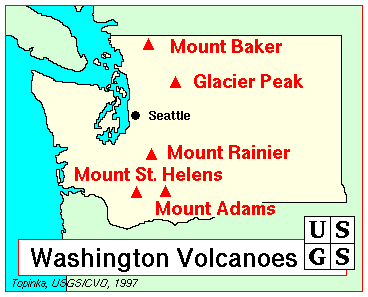
Washington’s hidden Glacier Peak volcano is among the most dangerous in the U.S.
But the volcano in Snohomish County remains the least-monitored and the least-studied in the Cascade range.
The snow-capped volcanoes of the Pacific Northwest can awaken at any time. Yet one of Washington’s most dangerous volcanoes remains the least-monitored and the least-studied in the Cascade range.
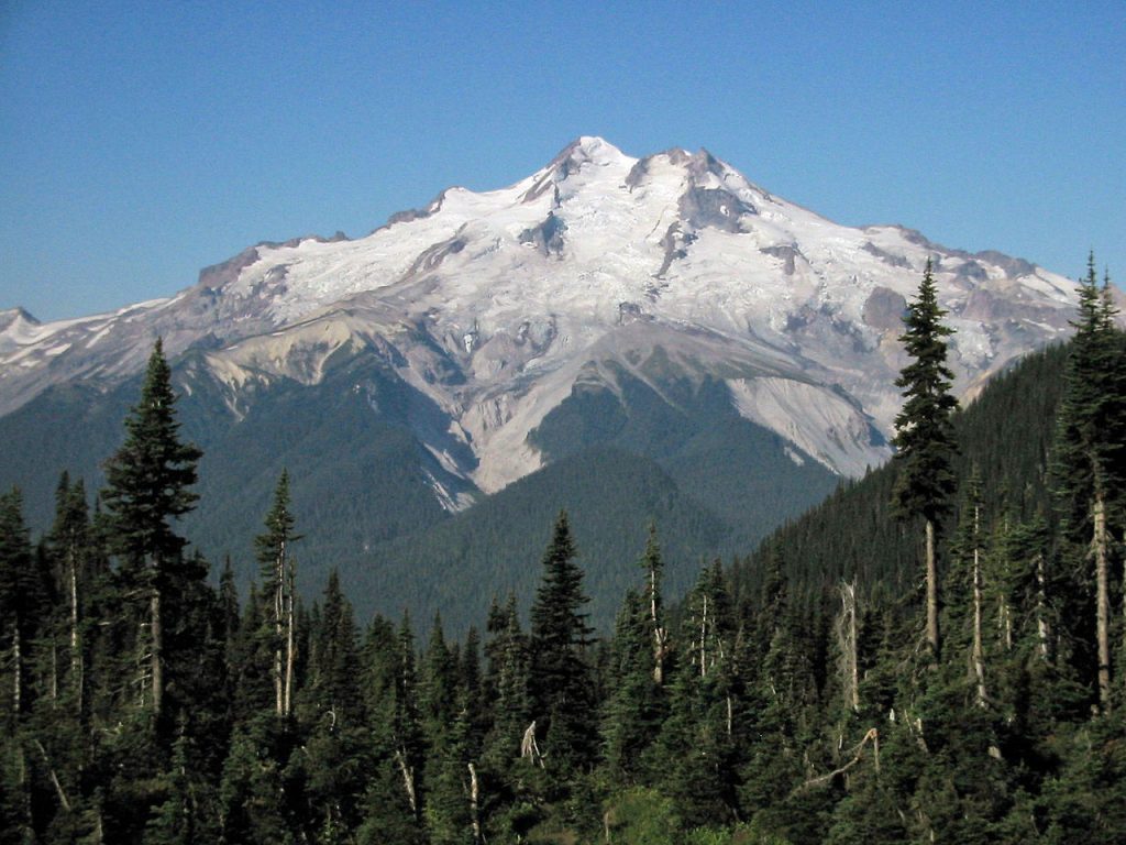
Glacier Peak, just 70 miles northeast of Seattle, is ranked by volcanologists among the country’s highest-threat volcanoes and has unleased eruptions five times bigger than Mount St. Helens in 1980.
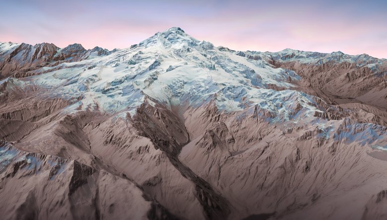
The small volcano, towering at 10,541 feet, is one of the state’s most active and explosive volcanoes.
Its latest eruption was about 300 years ago. But since the end of the last ice age, the volcano has erupted repeatedly in at least six episodes — including two outbursts five times bigger than the blast that blew Mount St. Helens apart on May 18, 1980.
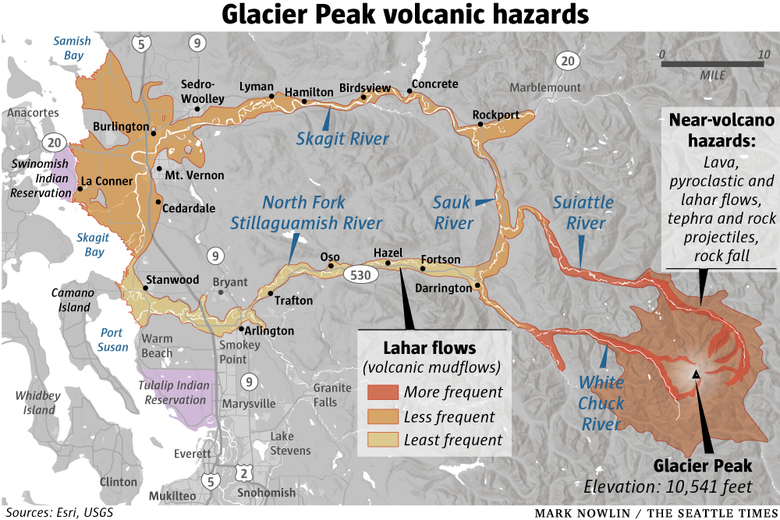
“An eruption of that scale today would bury nearby communities like Darrington and Rockport under slurries of mud and debris called lahars. Roiling columns of ash more than 100,000 feet high would disrupt air traffic across the region, while sediment-laden floods could reach the Puget Sound lowlands and possibly even threaten Interstate 5.“
Glacier Peak volcano under monitored
The USGS ranks Glacier Peak among the country’s highest-threat volcanoes. But the only monitoring is done by a single seismometer southwest of the summit — far less instrumentation than on any other Cascade volcano.
The agency also has yet to complete a geologic map of the area.
The problem is partly lack of money and staff, and partly because Glacier Peak is so hard to get to. Because it’s in wilderness, geologists have to pack in all their gear — then pack out heavy rock samples.
Hiking in to a base camp takes nearly two days, then it’s a cross-country scramble to reach remote ridges and valleys in search of signs of past eruptions. “It’s a lot of forcing your way through the devil’s club and dense forests and navigating really, really steep terrain,” Moran said.
Volcano Early Warning
The USGS hopes to install four additional seismometers soon, while ongoing geologic field studies aim to fill in gaps in the volcano’s eruptive history. But the agency estimates it needs at least a dozen instruments on Glacier Peak to effectively track the tiny earthquakes and ground motion that can signal an impending eruption.
Progress could be accelerated if Congress approves the Volcano Early Warning and Monitoring Bill to fund volcano research and establish a center to track data from volcanoes around the clock.
“The safety of our communities is paramount, and our legislation will ensure we have the science, technology and monitoring needed to keep people informed and safe,” Cantwell said in a statement.
Glacier Peak Dangers
In addition to explosive eruptions and lahars, Glacier Peak’s repertoire includes formation of lava domes, parts of which collapsed repeatedly during past eruptions to form scorching avalanches of rock and debris called pyroclastic flows. The flows incinerate everything in their path — which makes Glacier Peak’s lack of close neighbors a good thing.
The thick vegetation that covers the mountain makes it hard to trace the path of past pyroclastic flows and lahars, so the USGS commissioned lidar, or laser mapping, that was finished in 2016.
The technique digitally strips away vegetation, revealing the bare landscape. Features like lahars and lava flows pop out with unprecedented clarity, Moran explained.
The resulting maps underscore the risk to the Stillaguamish and Skagit Valley communities closest to the mountain, many of which were built on the thick deposits left by past lahars.
In a worst-case eruption, debris flows or their muddy remnants might reach as far as Arlington, Stanwood, Mount Vernon and La Conner.
As scientists assemble a fuller picture of Glacier Peak’s hazards, officials in Snohomish County have been working to raise awareness and reduce the danger, where possible.
The county requires anyone who wants to build in the danger zone to sign a disclosure that makes it clear the property is “subject to periodic and potentially life-threatening destructive mud, water and debris flows.”
Over the past year, emergency managers posted the first education and warning signs in the Darrington area. They plan to install more in the near future, said Dara Salmon, deputy emergency management director. County residents can also sign up to get emergency alerts for a wide range of natural disasters, including eruptions and lahars.
“I think awareness is higher than it used to be,” Salmon said, “But we still have a ways to go.”
And nobody knows when this very dangerous volcano will erupt next! By the way you can download a new documentary film about Cascadia Below… It’s really worth your money! (click on the picture below).
Be ready, Get prepared. More geology news on Strange Sounds and Steve Quayle. [Seattle Times]


Glacier Peak should have the reptilian secret underground base (mountain underground base). As I mentioned before, mines, tunnels and caves are all part of the reptilian secret underground bases. There is a legendary Monte Cristo mines next to Glacier Peak. That mines in high mountain was funded by the country’s richest reptilian man, John D. Rockefeller. For sure, at certain point, Glacier Peak will erupt and blow out all the reptilian underground bases around it, and wash away all the reptilian villages.
Monte Cristo — Thumbnail History
http://www.historylink.org/File/8404
Do you remember the huge landslide, probably the largest landslide in the US history, Oso landslide in Washington? Oso is near Glacier Peak, too.
The March 2014 landslide engulfed 49 homes and other structures in an unincorporated neighborhood known as “Steelhead Haven” 4 mi (6.4 km) on the south side of the North Fork of the Stillaguamish River, east of Oso, Washington. It also dammed the river, causing extensive flooding upstream as well as blocking State Route 530, the main route to the town of Darrington (population 1,347), approximately 15 miles (24 km) east of Oso. Sheriff’s Office confirmed 43 fatalities after remains of the final victim had been located and identified.
https://en.wikipedia.org/wiki/2014_Oso_mudslide
03-23-2014 Oso Mud Slide
https://www.youtube.com/watch?v=4WwdPT07FfI
OSO was terrible, yes