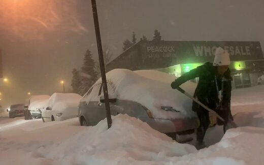
Blizzard-like conditions, record volumes of snow and ice started accumulating Sunday and Monday across Alaska and NW Canada, blocking roads, knocking down power for thousands and forcing school and businesses’ closures.
The extreme cold temperatures are due to a frigid Arctic air moving farther south than expected.
Alaska
“It seems like a perfect storm,” said Alaska Electric Light and Power’s Debbie Driscoll. “We had a lot of snow and also a lot of heavy ice.“
On Nov. 1, Juneau Airport broke a record when it got 7.6 inches of snow (old best mark: 6.6 inches).
Definitely the closest thing I can recall to an ice storm in Juneau. A heck of a 1-2 punch for our trees when you add in the heavy snow on top of the ice. ? pic.twitter.com/ElMhYt7yJX
— Erin Anais Heist (@erinanais) November 2, 2020
Power outages swept across Juneau Sunday afternoon, putting tens of thousands people in the dark. Due to ice, trees dropped on lines.
In Fairbanks, -22°F was measured at the city’s International Airport. This is November 2’s third coldest temperature in recorded history after -33°F in 1907 and -24°F in 1992 and 1975.
We do have blizzard warnings in Southwest Alaska. pic.twitter.com/0E7vqS4IPs
— Rick Thoman (@AlaskaWx) November 3, 2020
Frigid temperatures were also recorded in North Pole (-25°F), Manley Hot (-25°F), Springs (-26°F), Eagle (-27°F), Goldstream Valley (-27°F), Wiseman (-24°F), Circle (-30°F) and a whopping -40°F in Chicken.
This is the first time since 2008 that -40°F has been recorded this early in the season for the entire state of Alaska and the earliest day in the season that Fairbanks has reached 20 below since 1996.
And it seems like these extreme temperatures and the intense snowfall will continue throughout the week.
Yukon, Canada
Meanwhile, long sections of the Alaska Highway and Klondike highways were closed on Monday after a morning of heavy snowfall and also shut down Yukon’s main airport.
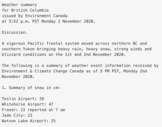
Doug Lundquist, a meteorologist with Environment Canada, has worked in B.C. and Yukon for over three decades, but says he’s “never quite seen a storm like this.“
Just enjoying our evening hurricane/snowstorm. Supposed to get 2ft overnight.? Also notable: cat with full send into the storm & husband enjoying that moment to the fullest ?? #yukonvet #9liveschallenge #vetmedlife #hurricane #snowstorm #animals #sitkagear #drO #Winteriscoming pic.twitter.com/EkxxtldsFV
— Michelle Oakley (@YukonVet) November 2, 2020
More than 47cm (1.54ft) of snow fell on Monday alone in Whitehorse, a new daily record for November in the region.
Great video from @CBCNorth’s Wayne Vallevand of the snow in #Whitehorse today. pic.twitter.com/w3R48bA0gD
— Philippe Morin (@YukonPhilippe) November 3, 2020
In fact, it turns out that Monday’s snow was Whitehorse’s highest daily snowfall for any day in any month!
Talking to people in #Whitehorse today, I met neighbours and family helping each other clear all this snow pic.twitter.com/SKwPuYeeRU
— Philippe Morin (@YukonPhilippe) November 3, 2020
Snow and deep temperatures are coming back. This is inline with historically low solar activity. More on Strange Sounds and Steve Quayle.



It looks like a puppy is sleeping on top of the crosswalk button.
Always good to have roadside emergency supplies in back of vehicle. Warm blanket, firearms and ammo, water, foods, first aid, lighter, radio, signal flares, cellphone, charger, etc…
People can die in blizzards, if they go into a ditch and nobody sees them.