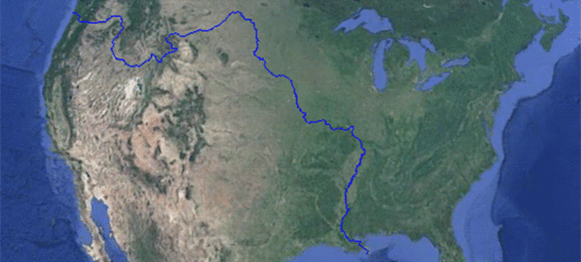
The Pacific creek starting in the Teton Wilderness of Bridger–Teton National Forest, Wyoming parts the USA in two at an unusual hydrologic site called the Parting of the Waters.
And amazingly, this small river separates the USA in two and links the Atlantic with the Pacific oceans.
Yes! No matter how hard you try not to, you will have to cross this creek to go from North to South or vice versa.
What is the “Parting of the Waters”?
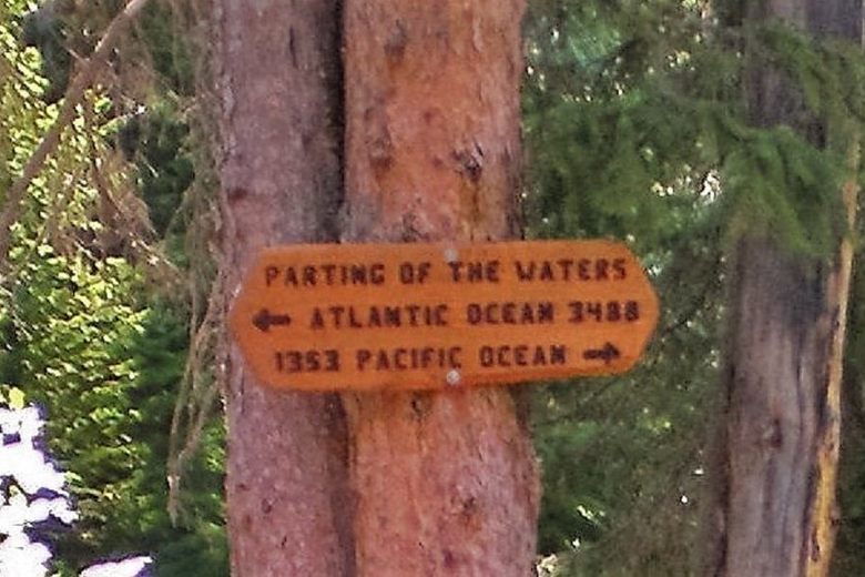
The Parting of the Waters is a rare natural hydrologic bifurcation at Two Ocean Pass on the Continental Divide. Here, North Two Ocean Creek splits into two equal-looking streams: Atlantic Creek (heading east) and Pacific Creek (heading west). From this one fork, water goes 3,488 miles (5,613 km) to the Atlantic via the Yellowstone–Missouri–Mississippi, and 1,353 miles (2,177 km) to the Pacific via the Snake–Columbia. A wooden sign at the site even gives those mileages. Nature’s choose-your-own-adventure for a water droplet.
Why it’s unique
- Continental Divide “bulge”: Instead of a knife-edge ridge, the Divide spreads into marshy meadow, so water actually covers the Divide—making the entire North Two Ocean Creek drainage technically part of the Divide here.
- Fish can cross oceans (sort of): Biologists point out this pass likely let Yellowstone cutthroat trout move between the Snake (Pacific side) and Yellowstone (Atlantic side) drainages—an aquatic “Northwest Passage.”
- National Natural Landmark: The site was designated the Two Ocean Pass National Natural Landmark in 1965 for its scientific rarity and beauty.
How to visit (read this first)
This wonder sits in remote grizzly country south of Yellowstone. Most hikers and riders reach it via long backcountry routes from near Moran or the Pacific Creek roadheads. Expect 30–40+ miles round trip depending on your approach, wilderness navigation, and variable conditions. It’s an unforgettable trip—but not a roadside pullout. (Always check current trail/road status, carry bear spray, and follow backcountry regulations.)
At the fork
The exact split is a serene, shallow “Y” in the creek. Step in and you’re literally nudging molecules toward different seas. East fork → Atlantic Creek (to the Yellowstone, Missouri, Mississippi, Gulf of Mexico). West fork → Pacific Creek (to the Snake, Columbia, Pacific Ocean). The Continental Divide here isn’t a line—it’s a living seam.
Need-to-know distances
- Atlantic route: 3,488 miles to the Atlantic/Gulf via Atlantic Creek → Yellowstone → Missouri → Mississippi.
- Pacific route: 1,353 miles to the Pacific via Pacific Creek → Snake → Columbia.
References & Further Reading
💌 If this helped you, support Strange Sounds: PayPal · Donorbox
📰 Subcribe to the Strange Sounds Newsletter! You will love it!


…Anybody see Moses…?
[…] Go to Link: https://strangesounds.org/2014/04/a-small-creek-splits-the-us-in-two-and-connects-the-atlantic-and-pa… […]
But where does it start? That was the question.
The Pacific creek starting in the Teton Wilderness of Bridger-Teton National Forest in the U.S. state of Wyoming parts the USA in two at an unusual hydrologic site called the Parting of the Waters.
http://en.wikipedia.org/wiki/Pacific_Creek_(Teton_County,_Wyoming)
But where does the creek start and come from?
A creek splits in two in the Teton Wilderness Area of the Bridger-Teton National Forest.
Why do you credit Reddit for all of the photos when only one of them actually came from Reddit? The map is the only thing that was on that Reddit post. The other 2 photos were linked in a 22 Words post earlier this week that actually cited the proper sources, though you didn’t source 22 Words or the original sources in your post.
Sorry but the second thread on reddit is a twitter picture showing my second picture that I found on Reddit! But cool that you send other sources. Thank you!