Did you know that nearly every year a ground shift equivalent to a magnitude 6 earthquake occurs below the city of Seattle? And that these shifts happen so slowly, that no one on the surface can feel them?
The hundreds of small earthquake that rattle the Pacific Northwest right now are part of a more larger and still mysterious process called a “Slow-Slip” earthquake event.
These slow earthquakeshappen periodically as the Juan de Fuca and North American plates slide past each other.
According to their knowledge, scientists have calculated that this seismic phenomenon happens about every 14 months.
The problem is that the last slow slip event along the Cascadia Subduction Zone took place in October 2020. That’s THREE months and not fourteen!
So why are these giant swarms of earthquakes suddenly taking place at higher pace? Why are they increasing in magnitude? Is Cascadia waking up?
Unknown Process
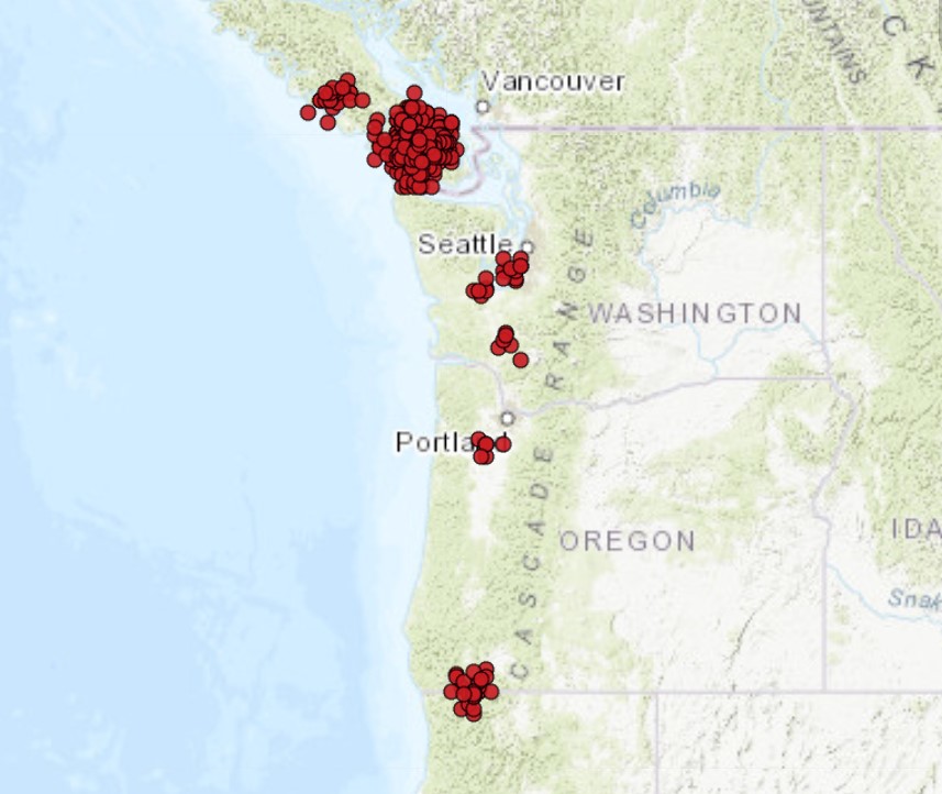
Slow slip events are accompanied by a seismic phenomenon known as tremor, which registers on seismograms as imperceptible vibrations that are recorded up and down the Pacific Northwest (denoted as blue dots on the map below). This simultaneous but repeating over time occurrence of slow slip and tremor is commonly referred to as Episodic Tremor and Slip (ETS).
Although ETS events fill a continuous zone along the entire Pacific West Coast from northern California to Vancouver Island (what is called, Cascadia), they actually rupture distinct patches through time.
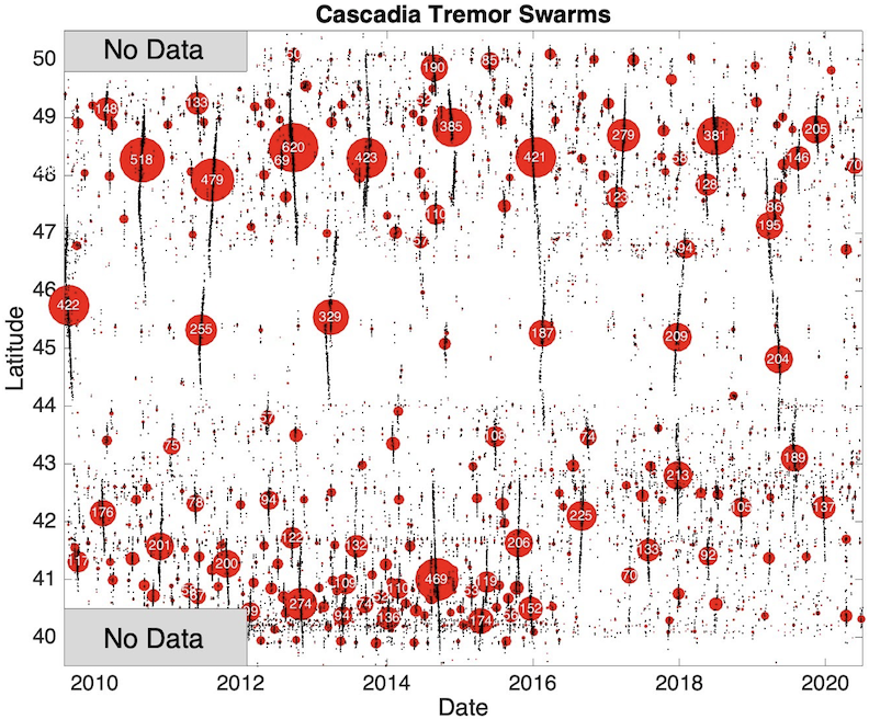
As mentioned above, ETS events occur periodically. However, the periodicity at which these events occur, or the recurrence interval, is location-dependent. For example, ETS events occur more frequently in northern Washington (obout every 14 months) than they do in central Oregon (about every 22 months).
From the figure below and the map at the top of this article, we see that Cascadia is roughly split into three segments (north, central and southern Cascadia), with breaks at about latitude 47N and 44N. Each segment has its own unique pattern of recurrence intervals.
Unknown process
The geological processes that control when ETS occurs in Cascadia are still relatively unknown.
Southern Cascadia stands out as having more frequent events, but it is unclear why this is the case.
What sets southern Cascadia apart from the rest of the margin and allows it to have such short recurrence intervals between ETS events?
San Andreas Fault
One possible explanation may be its proximity to the northern San Andreas fault system. In northern California, the Cascadia subduction zone ends, and the plate boundary transitions into the San Andreas fault, a strike-slip system between the Pacific and North American plates.
Located less than 100 km apart, it may be possible that activity on the northern San Andreas fault is encouraging slow slip to occur in southern Cascadia and shortening the recurrence interval in this region.
Small stress changes on the northern San Andreas fault may be influencing the timing of ETS in southern Cascadia.
How much slip occurs during such events
We know that an average ETS event in northern Cascadia results in ~2 cm of slip on the fault at depth.
Determining the amount of slip that occurs during ETS events in southern Cascadia is important for understanding how much strain these events are releasing along the megathrust fault.
Ultimately, this strain may be transferred onto the locked seismogenic zone, bringing it incrementally closer to failure.
Scientists predict the “Big One” will likely occur during one of these slow slip events. Moreover, there were only 4 months between the two last slow slip events (and not the 14 or even 22 months calculated by scientists. So one thing is clear… Something weird is going on along the Cascadia Subduction Zone… And if you have already read this amazing new Yorker’s article about the next Cascadia rupture and its tsunami, then should should prepare right now!
Watch
Now subscribe to this blog to get more amazing news curated just for you right in your inbox on a daily basis (here some examples of our new newsletter).
You can also follow us on Facebook and/ or Twitter. And, by the way you can also make a donation through Paypal. Thank you!


Did you notice that the cluster of quakes in Seattle, Portland and half between the two, each are directly west of a volcano. Seattle cluster directly west of Mt Rainer, mid way directly west of Mt St Helen and the Portland cluster directly west of Mt Hood.
I have no idea what that means other than it being a visual observation.
That’s right. Good obs. Also, if a cataclysm happens, then all states east of the left coast will be facing hoardes of hungry zombies encroaching on their land. ☠
The earthquakes are near perfectly aligned and near perfectly separated by distance in such a way that over 96% of these are man-made earthquakes. It’s as if someone were running spaced periods on a keyboard, and there are the quakes on the zoom part of the map. https://pnsn.org/tremor
I have NEVER seen such perfectly aligned horizontal and vertical earthquake strikes in nature recorded as what’s on the Feb 4 2021 zoom in. It is 100% man-made or a fraud. Which, I know not since I do not live in the area of these ALLEGED quakes.