Meteorologists warn that one of the busiest winter weather patterns in decades will continue to bombard much of the nation with a host of impacts into next week.
Several weather systems are lining up with the likelihood to bring more snow and ice to the Midwest and Northeast through the end of next week.
Winter storm every 2-3 days
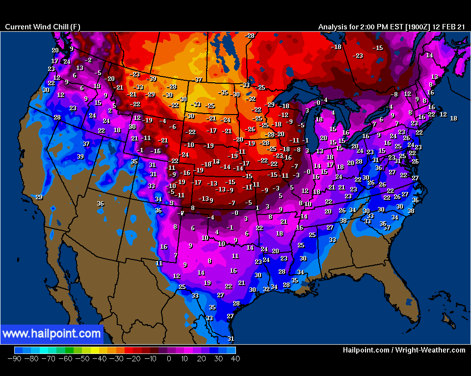
Winter storms could arrive every two to three days amid the tumultuous pattern, which is due in part to a major buckling of the jet stream. The river of high winds aloft plunged southward over the central United States then swung up along the Atlantic coast in recent days, setting the path for storms to ride along. That active storm track will be fueled by the collision of Arctic air sprawling across the middle of the nation and milder air holding its ground in the Southeast.
Two systems will come into play during the next storm late this week into this weekend, including on Valentine’s Day in the Northeast.
One storm was already sweeping across Wyoming, Nebraska, Iowa and northern Kansas with light to moderate snow on Friday. This storm and its snow will continue to shift eastward across the Midwest during Friday night and Saturday.
Meanwhile, a secondary storm is expected to push northward up the Eastern Seaboard this weekend.

“Both weekend systems are forecast to remain weak with the snow portion of the precipitation on the nuisance end of the spectrum,” AccuWeather Senior Meteorologist John Feerick said. “But even a light amount of snow and especially a thin coating of ice can lead to dangerous travel conditions.“
Look how cool freezing temperatures can be:
In general, 1-3 inches of snow is expected from eastern Wyoming to the to the Lower Peninsula of Michigan, but heavier amounts of 3-6 inches will occur across eastern Wyoming, southwestern South Dakota and Nebraska, where up to 8 inches are predicted.
“Chicago is another spot where heavier snow on the order of 3-6 inches can occur from Friday night to Saturday due some enhancement from Lake Michigan,” AccuWeather Senior Meteorologist Courtney Travis said.
A few additional pockets of 3-6 inches of snow can develop around the Great Lakes as well.

Farther to the east, most of the moisture associated with the storm pushing northward along the Atlantic Seaboard may stay out to sea.
Snowfall accumulations of 1 to 3 inches are expected from part of northern Virginia to Maine Saturday into Sunday, but as with any storm, pockets of somewhat heavier snow can develop with the risk of a few places ending up with 3-6 inches.
“Snow over much of this zone may be intermittent, where the rate of snow varies and even stops for a time,” AccuWeather Senior Storm Warning Meteorologist Brian Wimer said.

Some areas struck by a major ice storm that cut power and led to treacherous travel late this week could once again get more ice from this storm.
Washington, D.C., Philadelphia, New York City, Pittsburgh and Boston are in the zone where a wintry or icy mix is forecast from Saturday to Sunday.
“There is a risk of 0.25 to 0.50 of an inch of ice to build up in parts of Virginia and West Virginia with the storm this weekend,” AccuWeather Meteorologist Randy Adkins said.

As the storm finishes up in New England on Sunday, the next winter storm will already be producing a large swath of snow over portions of Texas and Oklahoma. That storm is then forecast to head northeastward next week.
A light wintry mix, including some ice, is likely to persist from southern New England to the southern Appalachians and Piedmont areas of the Southeast from Sunday into Monday. That will occur even after the weak storm pair leaves the East ahead of the next storm’s arrival.
“This means that icy conditions may continue in between storms from part of the interior South to the Northeast states this weekend into early next week,” AccuWeather Lead Storm Warning Meteorologist Joe Bauer said.
“This light precipitation can be every bit as dangerous to drive and walk on as a major storm, and motorists and pedestrians should be on the lookout,” Bauer added. you remember?
Since that south-central U.S. storm system is likely to be stronger than the weekend system, heavier precipitation, including snow and ice, is expected to unfold. However, it may be a complex setup with not just a snow or rain scenario.
Over a large part of the mid-Atlantic and New England regions, only a shallow layer of cold air may be in place. That means that a period of sleet and freezing rain is more likely, instead of just rain or snow.

“There could be significant icing from parts of eastern West Virginia and northern Virginia to portions of northern Maryland, Pennsylvania, New York state and central and southeastern New England Monday night into Tuesday,” Rayno said, adding that the biggest snowfall would likely occur north of the New York State Thruway and into parts of northern New England.
The storm predicted to shift northeastward from the South Central states will be weakening as it moves into the Ohio Valley on Monday night. Cold air may put up more of a fight in the Northeast as a result.

“Buckle up!” Rayno said, “because this will be a busy weather pattern right into next week. And there could be another weather system we’re tracking from the Northwest to the South Central states during the middle to latter part of next week.“

So yes, the weather is going crazy in the US, and actually in most parts of the world.
Now subscribe to this blog to get more amazing news curated just for you right in your inbox on a daily basis (here an example of our new newsletter).
You can also follow us on Facebook and/ or Twitter. And, by the way you can also make a donation through Paypal. Thank you!


You’ll never hear any globull warming propaganda during February.