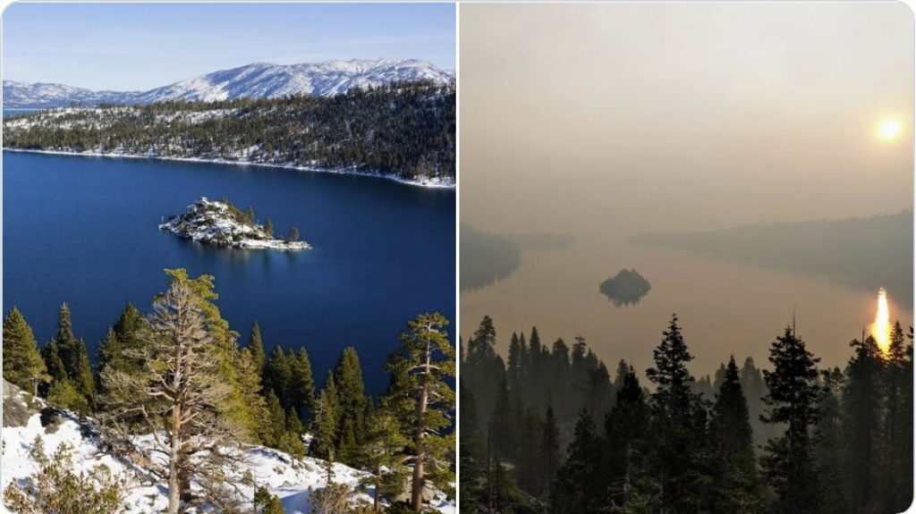
The still-growing Caldor Fire has prompted numerous evacuations across much of South Lake Tahoe, California on Monday as smoke and ash blanket communities.
Yes, like during dramatic volcanic eruptions, ash is falling over residents’ homes, gardens and cars in the vicinity of the blaze, while gas and smoke poison the air!
As shown in the pictures below, large chunks of ash are falling from the sky and the air quality becomes dangerous as the fire, which has been burning in the Sierra Nevada since Aug. 14, swells across 177,260 acres.
This (ash) was in my back yard (south Lake Tahoe). Lemon for size comparison. pic.twitter.com/M1oSIdahwm
— Rachel (@rach_frederick) August 26, 2021
The same weird phenomenon occurred last year during the Glass Fire in California, too…
Low overnight humidity and “critical fire conditions” have kept the fire actively burning and contributed to “ember casts” traveling nearly a half mile, according to the U.S. Forest Service. A red flag warning was issued until Sept. 1.
Sieh dir diesen Beitrag auf Instagram an
Fiery embers are carried in the wind away from the fire — and can spread the wildfire further.
Raining ash in Twin Bridges #CaldorFire pic.twitter.com/pc1G2c6tqf
— Abigail Vaerewyck (@abbyvaerewyck) August 27, 2021
Air quality levels around the Caldor Fire have also reached hazardous levels, the National Weather Service reported.
Parts of South Lake Tahoe and Nevada saw air quality levels higher than 500 as of Monday evening, according to AirNow’s Fire and Smoke map. Unhealthy air ranges from 151 to 200 and 301 to 500 means “health warnings of emergency conditions.”
Size of the ashes and singed leaves that fell at #strawberrylodge 25 miles away during the start of the #CaldorFire XL-hand pic.twitter.com/70B3Jgzcx6
— ScotTahoe (@ScotTahoe) August 25, 2021
Thick concentrations of hazardous smoke levels in Placerville and parts of South Lake Tahoe may take longer to clear, USFS Wildland Fire Air Quality Response Program reported.
They are evacuating Meyers now. If you didn’t notice the chunks of coal falling from the sky earlier, nows the time. #CaldorFire pic.twitter.com/Ohr8hsbWTT
— ??Jenn Basalone (@pennyblackio) August 30, 2021
And hazy smoke will likely remain over northeast California and western Nevada for the rest of the week, the National Weather Service said in a special weather statement Monday afternoon.
Ash fall accumulation from today in Meyers on the van we packing. #caldorfire pic.twitter.com/ozdKeO3gs5
— Susie Kocher (@UCsierraforest) August 26, 2021
The Caldor Fire tearing through northern California has forced evacuations of one of the state’s most popular resort areas. Much of idyllic lake town South Lake Tahoe is under an evacuation order and a red flag warning is in effect across the Northern Sierra region.
Mass evacuations along Highway 50 toward Stateline, traffic at a standstill. @NorthBayNews #Caldorfire pic.twitter.com/4WrEuze0Hg
— Kent Porter (@kentphotos) August 30, 2021
Firefighters have been battling the blaze for two weeks, and Gov. Gavin Newsom was forced to declare a state of emergency in El Dorado County earlier this month. The fire has burned over 276 square miles, destroyed more than 470 homes and injured at least five people, but is only about 15% contained.
#CaldorFire This How Lake Tahoe looked like earlier this year in 2021, and how it looks right now…. pic.twitter.com/lbdMdGBslj
— DanielFireCopter (@DanielFireTruck) August 30, 2021
Conditions on the ground have worsened since Sunday. Crews face low humidity and gusty winds as the fire races east and threatens to reach Lake Tahoe, but the California Department of Forestry and Fire Protection expects full containment by Sept. 8.
Two views from my favorite spot on Echo Summit. I just evacuated from the #Caldorfire. Jul 7 v Aug 26, 2021. Despite its beauty, the 1st photo doesn’t escape the pyrocene era CA is experiencing-the #Beckwourthcomplex plume is on the horizon. #tahoe #firewx pic.twitter.com/NIb6OCzBmz
— Craig Veramay (@CraigVeramay) August 27, 2021
In the wake of the blaze, before and after photos reveal charred buildings in abandoned communities and blackened forests beneath a smoke-filled sky. [Sacbee, Detroit Free Press]
Now, I’m sure that one of the major cause of these fires is the extreme drought currently drying up the West coast of the US.
You should really watch the documentary film: Megadrought – Vanishing Water and prepare accordingly!
Now subscribe to this blog to get more amazing news curated just for you right in your inbox on a daily basis (here an example of our new newsletter).
You can also follow us on Facebook and/ or Twitter. And, by the way you can also make a donation through Paypal. Thank you!
You should really subscribe to QFiles. You will get very interesting information about strange events around the world.


Meh, there’s buttclown gavin declaring an emergency so he can siphon off disaster money for his pet marxist buttclown projects.
Happens every year, nice scam they got going. Let forrest debris pile up (instead of removing it), add santa ana winds, then rake in federal disaster money — Jackpot!