
If it seems like a barrage of extreme rain events has been wreaking havoc across the country over the past week, you’re not imagining things. The latest resulted from an overnight deluge in central and southeastern Illinois, with some areas registering 8 to 12 inches of rain in less than 12 hours.
It’s the third 1-in-1,000-year rain event in the Lower 48 states in about a week.
The National Weather Service office in Lincoln, Ill., has received about 20 reports of flooding, mostly due to water inundating roads and intersections. Television affiliate WAND in Decatur, which is about 35 miles east of Springfield, reported cars submerged in high water with emergency crews involved in rescues. Minor flooding of several rivers has also occurred.
Flash-flood warnings have affected a large swath of central and southern Illinois from around Springfield to southeast of Effingham. That’s where months’ worth of rain has fallen because of a parade of thunderstorms. Many of them were “training” or repeatedly moving over the same neighborhoods.
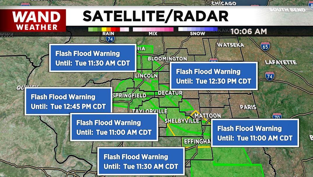
Even after the overnight downpours, storms appeared once again around sunrise Tuesday morning, drifting back over hard-hit areas that bore the brunt of the nocturnal drenching. It continued raining in the region through midday, with flash-flood warnings extending into the afternoon. It’s probable some areas will see rainfall totals surpass a foot.
You will never go without electricity with this Jackery portable power station!
“We’re still kind of waiting to hear on reports from some of the heaviest-hit areas, but based on radar estimates, we are seeing amounts of 8 to 12 inches across Jasper County, Ill.,” said Alex Erwin, a meteorologist at the Weather Service in Lincoln. “Late last night, before midnight, we received a seven-inch report from West Liberty in Jasper County, as well as a 5.5-inch report near Dundas in Richland County.”
Erwin said rainfall rates reached at least 2 inches per hour at times.
The stalled front responsible for the torrent in southern Illinois on Monday night into Tuesday is the same one that produced flooding in St. Louis and eastern Kentucky last week. The former saw its wettest day on record a week ago; the latter faced disastrous flooding Wednesday night; at least 35 people were killed.
Ahead of Monday night’s storms in Illinois, forecasts called for damaging winds, hail and the chance of an isolated tornado in the Midwest and Ohio Valley. At least one tornado did touch down from the same string of storms to the east near the West Virginia-Pennsylvania border.
Beneficial rainfall was mentioned ahead of the deluge by the Weather Service office in Lincoln, but a flood threat was not highlighted in its afternoon forecast discussion. “It could be a nice rainmaker for us in central Illinois, with [total precipitation] values ranging from a few tenths, while localized values could exceed an inch,” the office wrote.
However, stalled fronts can prove notoriously tricky for forecasters, the clashing air masses and convergence, or gathering of air, serving as a focal mechanism for storminess. To the south of the boundary, atmospheric moisture was pooling; a measure of that — known as precipitable water — climbing to around 2 inches.
It’s worth noting that precipitable water isn’t a limit to how much rain can fall, especially in situations where the moisture is continually being replenished by the wind flow. It’s akin to wringing a waterlogged washcloth into a bucket. Even though the washcloth can only carry a finite amount of water, if you keep wringing it out and then getting it wet again, eventually that bucket can overflow.
The moisture collected on the stalled front, which sat atop a heat dome sprawled over the southern United States. It was pumped northward into the area by a zone of high pressure offshore the Southeast United States.
Stock up on Iodine tablets for the next nuclear disaster…
Monday night’s event fits into a pattern of ultrarare high-end rain events that have struck the United States in the past week. What happened in St. Louis and Kentucky both fall under the umbrella of 1,000-year rain events, meaning the amount of rain that fell during such a short window would have only a 0.1 percent chance of happening any year.
Similarly, Weather Service precipitation frequency charts for the zone southeast of Springfield, Ill., indicate that the foot of rain that fell in less than 12 hours from this event constitutes another 1,000-year event.


HAARP IS VERY ACTIVE IN ALL THE WORLD?
@GaryA Do you think the sand in the air helped the rain totals? Would like to see the Earth wobble link? Covering the sky in unknown crap has NO effect? Extreme weather is normal (Joseph). Should sue anyone claiming or certifying the home was safe and not a risky investment (or deathtrap)?
https://hpiers.obspm.fr/eop-pc/index.php?index=realtime&lang=en
I’m no expert, but it looks like the axis is steady but the rotation speed is fluctuating a little?
Just the head waters, but has never happened before in the UK’s long history.
And the River Thames in the UK just dried up for the first time in history! Also, coal fired power plants in Germany are in trouble because the Rhine River has dropped to a level that is restricting coal shipments. Nothing unusual going on. Denial is a powerful thing. Jim Sinclair says, “The Only Thing Denial Does for You Is Reduce Your Options”.
Feel bad for the rural people suffering from this flooding. Big mess. More rain on the way too.
We Kentuckians are taking care of our neighbors. Clothes and other goods are already on the way to that area from every part of KY.
We survive by helping each other’s.
Draught and deluge. Record shattering heat and then unusual cold. Tidal sloshing in Hawaii and other locations. Weather app used to be fairly accurate, but last few years it’s all over the place. Sometimes it’s even raining, and app shows sunny. Then it gets quickly updated. Earth Wobble increasing. Not Geoengineering. Whoever put that out there has the power to cover all the details. Have most folks convinced, who know the extreme weather is not normal. Has anyone ever considered the Establishment is losing billions on insurance claims? If you have ever known a wealthy person, their greatest fear is losing money. That’s one reason they keep what’s going on secret, because they want you to stay in dangerous areas paying your mortgage until it’s too late to leave.