Nadir Crater: Scientists discover a 5-mile wide undersea crater created as the dinosaurs disappeared – Possible link to Chicxulub impact

2

An asteroid from space slammed into the Earth’s surface 66 million years ago, leaving a massive crater underneath the sea and wreaking havoc with the planet.
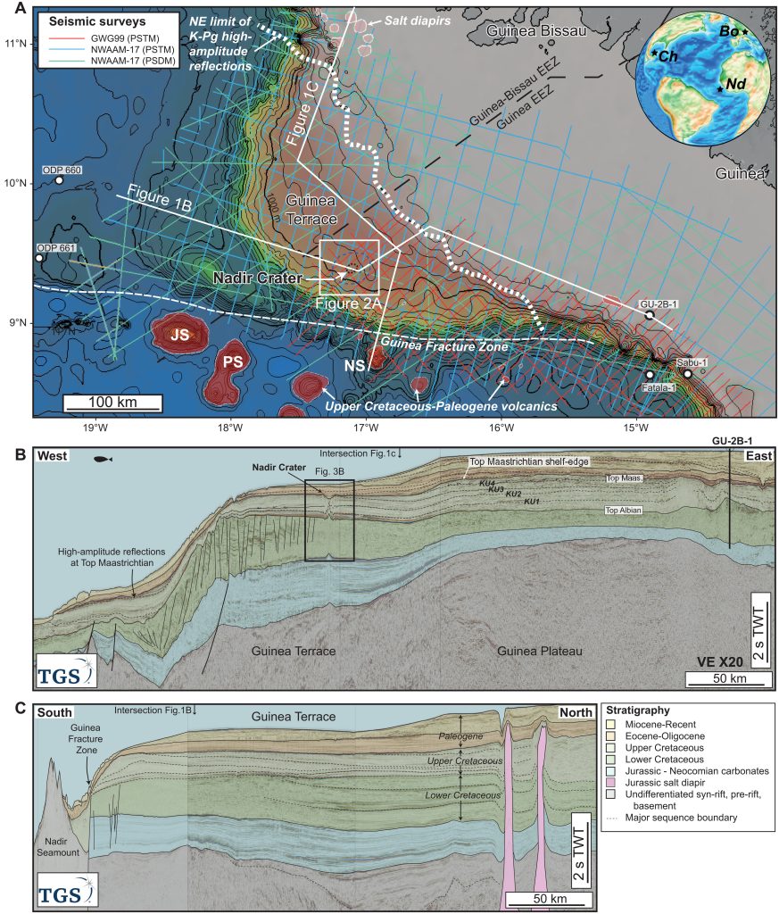
Fig. 1. Map and regional seismic sections showing location of Nadir Crater. (A) Regional bathymetry map of the Guinea Plateau and Guinea Terrace showing location of 2D seismic reflection and well data used in this study. JS, Jane Seamount; NS, Nadir Seamount; PS, Porter Seamount. The white dashed line shows the NE extent of high-amplitude discontinuous seismic facies at the top Maastrichtian interpreted as ejecta deposits and associated tsunami deposits. The north-east limit of this facies closely corresponds with the Maastrichtian shelf-slope break at the landward margin of the Guinea Terrace. Inset map shows a paleogeographic reconstruction of the Atlantic near the end of the Cretaceous, ~66 Ma ago, made using GPlates software (58). Ch, Chicxulub Crater; Nd, Nadir Crater; Bo, Boltysh Crater. (B). Regional composite 2D seismic reflection profile extending from the GU-2B-1 well in the east to the deep Atlantic basin in the west, showing the structural and stratigraphic character of the Guinea Plateau and Guinea Terrace. (C) North-South seismic profile from the salt basin in the north to the Nadir Seamount, south of the Guinea Fracture Zone. Data courtesy of the Republic of Guinea and TGS.
Map and regional seismic sections showing location of Nadir Crater. (A) Regional bathymetry map of the Guinea Plateau and Guinea Terrace showing location of 2D seismic reflection and well data used in this study. JS, Jane Seamount; NS, Nadir Seamount; PS, Porter Seamount. The white dashed line shows the NE extent of high-amplitude discontinuous seismic facies at the top Maastrichtian interpreted as ejecta deposits and associated tsunami deposits. The north-east limit of this facies closely corresponds with the Maastrichtian shelf-slope break at the landward margin of the Guinea Terrace. Inset map shows a paleogeographic reconstruction of the Atlantic near the end of the Cretaceous, ~66 Ma ago, made using GPlates software (58). Ch, Chicxulub Crater; Nd, Nadir Crater; Bo, Boltysh Crater. (B). Regional composite 2D seismic reflection profile extending from the GU-2B-1 well in the east to the deep Atlantic basin in the west, showing the structural and stratigraphic character of the Guinea Plateau and Guinea Terrace. (C) North-South seismic profile from the salt basin in the north to the Nadir Seamount, south of the Guinea Fracture Zone. Data courtesy of the Republic of Guinea and TGS. https://www.science.org/doi/10.1126/sciadv.abn3096

No, it’s not that asteroid, the one that doomed the dinosaurs to extinction, but a previously unknown crater 248 miles off the coast of West Africa that was created right around the same time. Further study of the Nadir crater, as it’s called, could shake up what we know about that cataclysmic moment in natural history.

Protect your home, cars and generators against EMP, solar flare and lightnings with EMP Shield, the best protection available

Uisdean Nicholson, an assistant professor at Heriot-Watt University in Edinburgh, happened on the crater by accident – he was reviewing seismic survey data for another project on the tectonic split between South America and Africa and found evidence of the crater beneath 400 meters of seabed sediment.

While interpreting the data, I (came) across this very unusual crater-like feature, unlike anything I had ever seen before,” he said.
It had all the characteristics of an impact crater.

To be absolutely certain the crater was caused by an asteroid strike, he said that it would be necessary to drill into the the crater and test minerals from the crater floor. But it has all the hallmarks scientists would expect: the right ratio of crater width to depth, the height of the rims, and the height of the central uplift – a mound in the center created by rock and sediment forced up by the shock pressure.

The discovery of a terrestrial impact crater is always significant, because they are very rare in the geologic record. There are fewer than 200 confirmed impact structures on Earth and quite a few likely candidates that haven’t yet been unequivocally confirmed,” said Mark Boslough, a research professor in Earth and Planetary Sciences at the University of New Mexico. He was not involved in this research but agreed that it was probably caused by an asteroid.

Boslough said the most significant aspect of this discovery is that it was an example of a submarine impact crater, for which there are only a few known examples.

You will never go without electricity with the best portable power station around!

The opportunity to study an underwater impact crater of this size would help us understand the process of ocean impacts, which are the most common but least well preserved or understood.

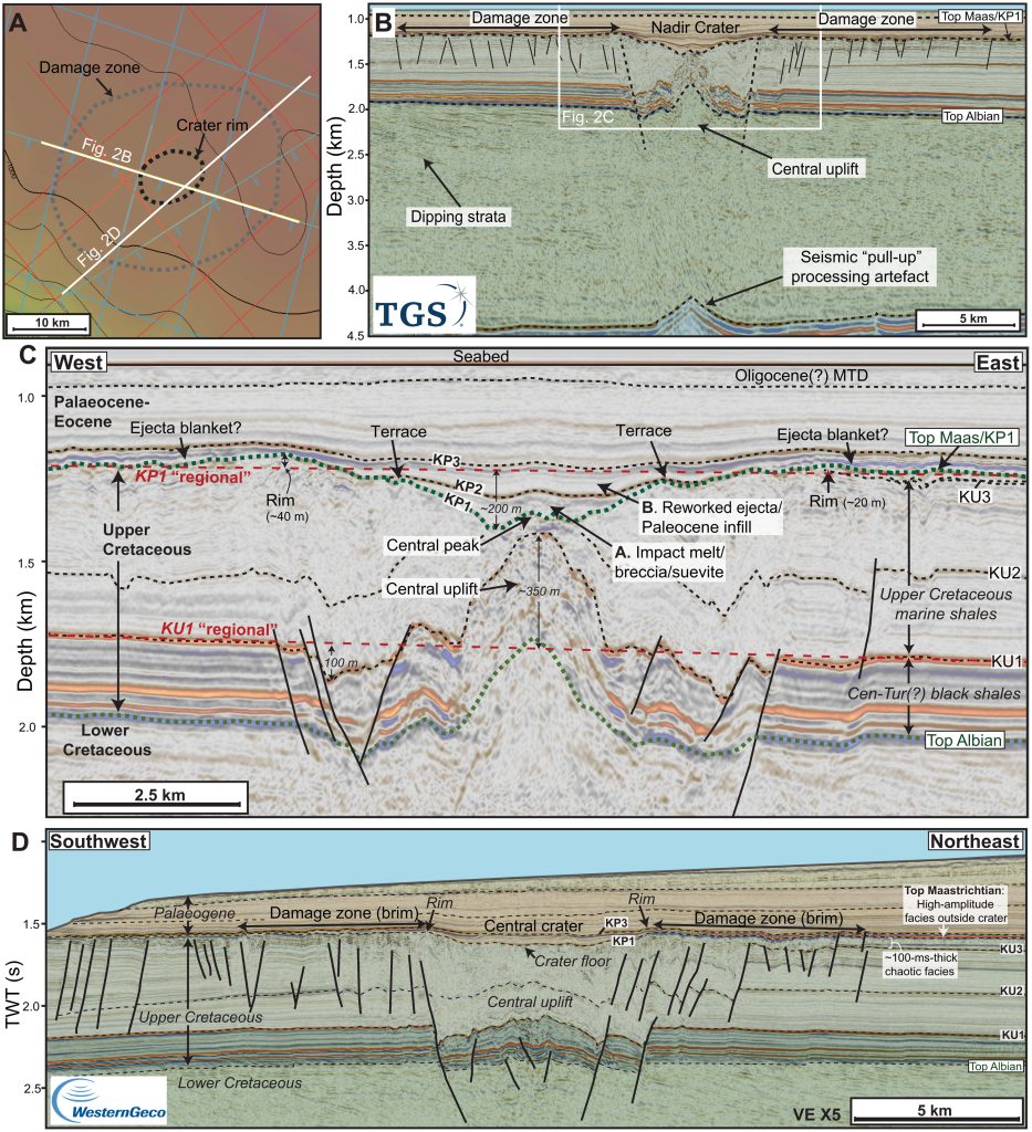
Fig. 2. Seismic characteristics of the Nadir Crater. (A) Seabed depth map of crater showing seismic line locations and the mapped extent of the crater rim and damage zone. (B) W-E seismic section (pre-stack depth migration – depth domain) across the crater, highlighting the crater morphology and damage zone, and the extent of subsurface deformation. Data courtesy of the Republic of Guinea, TGS and WesternGeco. Stratigraphic key is on Fig. 1. (C) Detailed seismic stratigraphic and structural elements of the crater. KP, Cretaceous-Paleogene sequence (KP1 equivalent to Top Maastrichtian); KU, Upper Cretaceous seismic horizons. KU1 and KP1 “regionals” are schematic reconstructions of these seismic horizons before formation of the crater at the end of the Cretaceous and are used to reconstruct a conceptual model of crater formation (Fig. 5). (D) SW-NE seismic section (pre-stack time migration – time domain) across the crater, showing crater morphology and seismic facies outside the crater, including high-amplitude seismic facies sitting above a ~100-ms-thick unit of chaotic reflections, interpreted to have formed as a result of seismic shaking following the impact event. Data courtesy of the Republic of Guinea and WesternGeco Multiclient.
Seismic characteristics of the Nadir Crater. (A) Seabed depth map of crater showing seismic line locations and the mapped extent of the crater rim and damage zone. (B) W-E seismic section (pre-stack depth migration – depth domain) across the crater, highlighting the crater morphology and damage zone, and the extent of subsurface deformation. Data courtesy of the Republic of Guinea, TGS and WesternGeco. Stratigraphic key is on Fig. 1. (C) Detailed seismic stratigraphic and structural elements of the crater. KP, Cretaceous-Paleogene sequence (KP1 equivalent to Top Maastrichtian); KU, Upper Cretaceous seismic horizons. KU1 and KP1 “regionals” are schematic reconstructions of these seismic horizons before formation of the crater at the end of the Cretaceous and are used to reconstruct a conceptual model of crater formation (Fig. 5). (D) SW-NE seismic section (pre-stack time migration – time domain) across the crater, showing crater morphology and seismic facies outside the crater, including high-amplitude seismic facies sitting above a ~100-ms-thick unit of chaotic reflections, interpreted to have formed as a result of seismic shaking following the impact event. Data courtesy of the Republic of Guinea and WesternGeco Multiclient. https://www.science.org/doi/10.1126/sciadv.abn3096

Cascading consequences

The crater is 8 kilometers (5 miles) wide, and Nicholson believes it was was likely caused by an asteroid more than 400 meters (1,300 feet) wide hurtling into the Earth’s crust.

While much smaller than the city-sized asteroid that caused the 100-mile-wide Chicxulub crater that hit off the coast of Mexico that led to the mass extinction of much of life on the planet, it’s still a pretty sizable space rock.

The (Nadir) impact would have had severe consequences locally and regionally — across the Atlantic Ocean at least,” Nicholson explained via email.

There would have been a large earthquake (magnitude 6.5 – 7), so significant ground shaking locally. The air blast would have been heard across the globe, and would have itself caused severe local damage across the region.

GOLD; SILVER for your IRA/401K; It’s time to invest in PRECIOUS METALS to fight INFLATION and achieve the retirement peace of mind you deserve

It would have caused an “exceptionally large” tsunami wave up 3,200 feet high (1 kilometer) around the crater, dissipating to around five meters high once it reached South America.

By comparison, the in-air explosion of a much smaller 50-meter wide asteroid in 1908 in Russia, known as the Tunguska event flattened a forest across an area of 1,000 square kilometers.

At 400 meters or so, the air blast (that caused the crater off West Africa) would have been orders of magnitude larger.

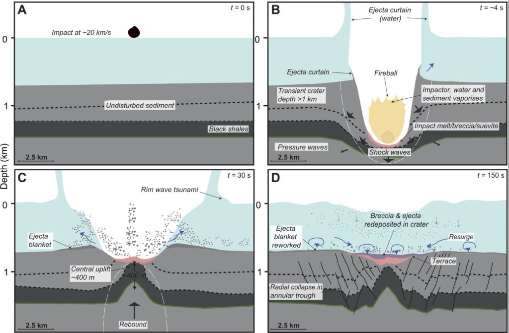
Conceptual model of the impact sequence at the Nadir impact site, based on seismic observations and analog models (6, 7, 21). (A) At time (t) = 0, the impactor hits the water surface at a velocity of ~20 km/s, initiating a rim-wave tsunami in its wake. (B) Several seconds later, the transient crater forms, as the impactor and a substantial body of water are vaporized. Impactites (melt rock and breccias) line the transient cavity. Tsunami waves propagate away from the evacuated crater. Shock waves cause substantial damage below and around the impact site, and seismic waves propagate across the plateau; (C) major uplift (~400 m relative to preimpact regional) occurs in the “rebound” crater modification phase, resulting in the formation of a raised crater peak; (D) radial collapse of the subsurface damage zone results in further modification of the crater, including the formation of terraces at the surface. Resurge of water transports substantial volume of ejecta and other sediment into the crater, deposited above the impactites.
Conceptual model of the impact sequence at the Nadir impact site, based on seismic observations and analog models. (A) At time (t) = 0, the impactor hits the water surface at a velocity of ~20 km/s, initiating a rim-wave tsunami in its wake. (B) Several seconds later, the transient crater forms, as the impactor and a substantial body of water are vaporized. Impactites (melt rock and breccias) line the transient cavity. Tsunami waves propagate away from the evacuated crater. Shock waves cause substantial damage below and around the impact site, and seismic waves propagate across the plateau; (C) major uplift (~400 m relative to preimpact regional) occurs in the “rebound” crater modification phase, resulting in the formation of a raised crater peak; (D) radial collapse of the subsurface damage zone results in further modification of the crater, including the formation of terraces at the surface. Resurge of water transports substantial volume of ejecta and other sediment into the crater, deposited above the impactites. https://www.science.org/doi/10.1126/sciadv.abn3096

Link to Chicxulub impact?

Information from microfossils in nearby exploration wells show that the crater was formed around 66 million years ago – at the end of the Cretaceous period. However, there’s still uncertainty – margin or error of around 1 million years – about its exact age.

Health Ranger Store: Lab-certified, non-GMO superfoods… JUST TRY IT!

Nicholson said it was possible that the asteroid strike was linked to the Chicxulub impact, or it could simply be a coincidence – an asteroid of this size would hit Earth every 700,000 years.

If linked, the asteroid could be the result of a break-up of a parent asteroid near the Earth – with the separate fragments dispersed during an earlier orbit of Earth, or it was possible that it was part of a longer-lived shower of asteroids that hit the Earth over a period of a million years or so.

Finding out the precise age is really critical to test this – again, only possible by drilling.

Even if linked, it would have been dwarfed by the Chicxulub impact, but it would have still added to the overall cascading set of consequences, he said.

Stock up on Iodine tablets for the next nuclear disaster

Understanding the exact nature of the relationship with Chicxulub (if any) is important to understand what was going on in the inner solar system at that time and raised some interesting new questions,” Nicholson said. “If there were two impacts at the same time, might there be other craters out there, and what was the cascading effect of multiple collisions?” [Science, CNN]

StrangeSounds.org has been banned from ad networks and is now entirely reader-supported CLICK HERE (or the banner below) TO SUPPORT MY WORK… I will send you a small gemstone if you give more than 25$… Thanks in advance!

Another way to support my work is by signing in to get FREE information about how to invest in GOLD, SILVER and other PRECIOUS METALS to limit the effects of inflation on your IRA/4001K… As the Dow Jones is sinking and the inflation is hiking it’s the right time to invest in precious metals!

You will finally find some great affiliate products that I recommend you to add to your disaster & preparedness kit:

qfiles by steve quayle

2 Comments

  1. “The cascading effect of multiple collisions.”

    Wish we could see something like from the perspective of the moon, eh? Wow!

    • For Gary:
      He(Gary) will know more on this topic, but when I was diving down the Niburu rabbit hole, I remember people were saying as Niburu passess closer it will drag planetary debris, and that debris will pelt the earth like Biblical hailstones. This was a few years back, but I still remember that tidbit.

      We have had more meteorites videotaped too, so it could be simply more cameras, or it could be something cosmic. Hard for me to make speculation as I don’t study Niburu that much.

Leave a reply

Please enter your comment!
Please enter your name here

This site uses Akismet to reduce spam. Learn how your comment data is processed.