A team of oceanographers at the Scripps Institution of Oceanography, working with a colleague from Chungnam National University and another from the University of Hawaii, has mapped 19,000 previously unknown undersea volcanoes in the world’s oceans using radar satellite data. In their paper published in the journal Earth and Space Science, the group describes how they used radar satellite data to measure seawater mounding to find and map undersea volcanoes and explains why it is important that it be done.
The ocean floor, like dry land masses, features a wide variety of terrain. And as with dry land, features that truly stand out are mountains — in the ocean they are called seamounts. And as on land, they can be created by tectonic plates pushing against one another, or by volcanos erupting. Currently, just one-fourth of the sea floor has been mapped, which means that no one knows how many seamounts exist, or where they might be. This can be a problem for submarines — twice U.S. submarines have collided with seamounts, putting such vehicles and their crew at risk. But not knowing where the seamounts are located presents another problem. It prevents oceanographers from creating models depicting the flow of oceanwater around the world.
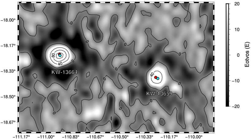
In this new effort, the research team set themselves the task of discovering and mapping as many seamounts as possible, and to do it, they used data from radar satellites. Such satellites cannot actually see the seamounts, of course, instead they measure the altitude of the sea surface, which changes due to changes in gravitational pull related to seafloor topography; an effect known as sea mounding. In so doing, they found 19,000 previously unknown seamounts.
In their paper, the team notes that other important reasons for mapping the ocean floor include things like assisting with sea-floor mining efforts — seamounts harbor vast amounts of rare-earth minerals. More complete seamount maps would also help geologists better map the planet’s tectonic plates and geomagnetic field. Also, some seamounts provide a habitant for a vast array of marine life.
But most importantly, they have a very strong impact on deep-sea ocean flow. As currents run into seamounts, they are pushed upward, carrying colder water with them, and mix in unknown ways. Mapping such currents has become more important as the oceans absorb more heat and carbon dioxide from the atmosphere and freshwater melt, due to ongoing climate change. [Phys]
My questions: How fast do all of these volcanoes grow? Which one is going to reach the surface first? Imagine the apocalyptic scenario of all of them eruptingWhich one will be the next Tambora or Anak Krakatoa?
FUNDRAISING: KEEP STRANGESOUNDS ONLINE!… THANK YOU FOR YOUR HELP! You can give through Credit cards, Debit cards and Paypal by using the form below. (You will get a gemstone gift for every donation above 50$! Send me your snail mail per e-mail)
You should also join my newsletter…YOU WILL LOVE IT…
I recommend following Qfiles for videos, podcasts and a wide compilation of alternative news…
 The following links feature products I recommend you to add to your preparedness plan to help and protect you and your family during an emergency:
- Protect your home and car with the best lightning and EMP protection available…
- Stock up on iodine pills for the next nuclear disaster…
- Use this filter to drink clean water at home!


