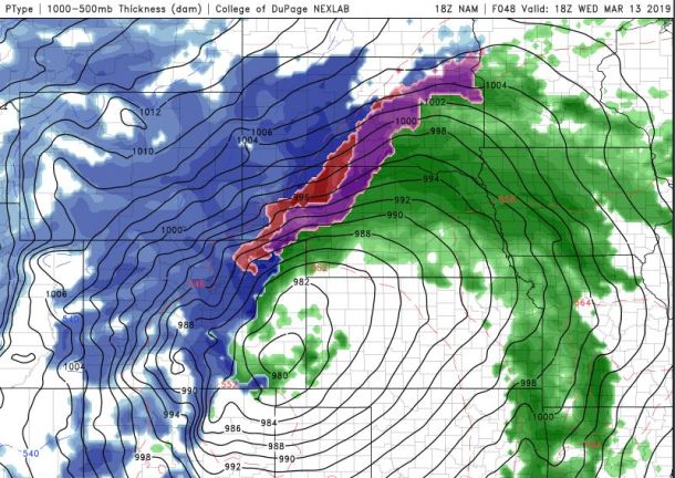
No, I’m NOT being sensational. Believe it or not, this IS … a thing! According to latest weather models, a BOMBOGENESIS will hit Colorado’s eastern plains, bringing DANGEROUS widespread blizzard conditions and snow drifts from 10 to 20 feet deep.

In the northern hemisphere areas of low pressure are called cyclones, and rapidly developing storms are often called bombs or weather bombs. To qualify as a ‘bomb cylcone’ an area of low pressure must drop at least 24 millibars in 24 hours or less. Current weather models show the center of Wednesday’s low pressure dropping anywhere from 24 to 30 millibars in less than a day as it gains strength over Colorado’s eastern plains.
Looks like we'll have a "Bomb" in the Plains Wednesday. A Bomb Cyclone is one where the pressure drops 24 millibars in 24 hours. Somewhat rare, very rapidly instensifying & powerful storms. My flight to Denver on Wednesday is probbbably going to be delayed pic.twitter.com/zPZsCwlklW
— Luke Dorris (@lukedorrisWPLG) March 11, 2019
Another term you may hear in meteorology when dealing with a storm like this is explosive cyclogenesis. Explosive refers to the rapid growth, and cyclogenesis means you have an area of low pressure that is gaining strength.
So what?
Regardless of what you call it, the results for anyone living along and east of Interstate 25 will be the same. Extremely strong winds and the predicted snow will mean widespread blizzard conditions with difficult to impossible travel. This type of weather scenario is extremely dangerous for ranchers and their livestock.
Some models still showing next week's lee side sfc low "bombing" out in SE Colorado/S Kansas, deepening at a rate ≥1 bergeron/24hrs. The term "bomb cyclone" is purely academic imo, but not very often we get to say bombogenesis here in Colorado. "Strong storm" also suffices #COwx pic.twitter.com/eJndcedhTF
— Nick Barlow (@Barlometer) March 10, 2019
Because of the prolonged period of wind it will be virtually impossible in many areas to measure the snow. Areas only expecting a few inches could still see drifts several feet deep in exposed areas. On the wide open plains drifts ranging from 10 to 20 feet deep will be possible.
Follow us on FACEBOOK and TWITTER. Share your thoughts in our DISCUSSION FORUMS. Donate through Paypal. Please and thank you
[CBSLocal]


