Unlike some of its perpetually active neighbors on the Kamchatka Peninsula, Raikoke Volcano on the Kuril Islands rarely erupts. The small, oval-shaped island most recently exploded in 1924 and in 1778.
The long dormant period ended around 4:00 a.m. local time on June 22, 2019, when a vast plume of ash and volcanic gases shot up from its 700-meter-wide crater and rose more than 12km (40,000ft) in the air.

Let’s start with an impressive video by Nikolay Pavlov / http://easttour.ru:
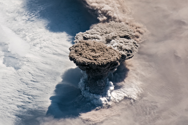
On the morning of June 22, astronauts on board of ISS shot a photograph of the volcanic plume rising in a narrow column and then spreading out in a part of the plume known as the umbrella region. The ring of clouds at the base of the column appears to be water vapor.
A thick plume of volcanic ash rises above the dense cloud cover in this close-up #Himawari8 view of the #Raikoke volcano’s eruption. This was the volcano’s first eruption since 1924. More imagery: https://t.co/wIF4txQIDW pic.twitter.com/vZExba5QDZ
— NOAA Satellites (@NOAASatellites) June 24, 2019
“What a spectacular image. It reminds me of the classic Sarychev Peak astronaut photograph of an eruption in the Kuriles from about ten years ago,” said Simon Carn, a volcanologist at Michigan Tech.
Look at the Sarychev vs Raikoke images below:
Two spectacular Kuril Islands #volcanic eruptions seen from the @Space_Station, ~10 years apart. Sarychev Peak in June 2009 and #Raikoke in June 2019. https://t.co/9XeO5kSQf6 pic.twitter.com/J00sGWbFnn
— Simon Carn (@simoncarn) June 25, 2019
“The ring of white puffy clouds at the base of the column might be a sign of ambient air being drawn into the column and the condensation of water vapor. Or it could be a rising plume from interaction between magma and seawater because Raikoke is a small island and flows likely entered the water.”
An unexpected series of blasts from the remote #Raikoke volcano in the Kuril Islands sent ash and volcanic gases streaming high over the North Pacific Ocean. https://t.co/ptL4i4dNOH #NASA pic.twitter.com/XAUziKxurK
— NASA Earth (@NASAEarth) June 24, 2019
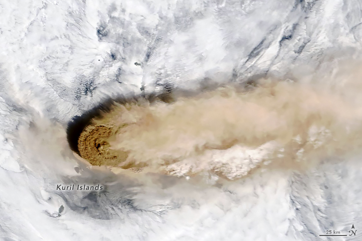
The second image from Moderate Resolution Imaging Spectroradiometer (MODIS) on NASA’s Terra satellite was shoit at the time, the most concentrated ash was on the western edge of the plume, above Raikoke.

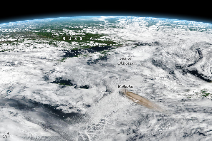
The third image, an oblique, composite view based on data from the Visible Infrared Imaging Radiometer Suite (VIIRS) on Suomi NPP, shows the plume a few hours later. After an initial surge of activity that included several distinct explosive pulses, activity subsided and strong winds spread the ash across the Pacific. By the next day, just a faint remnant of the ash remained visible to MODIS.

Since ash contains sharp fragments of rock and volcanic glass, it poses a serious hazard to aircraft. The Tokyo and Anchorage Volcanic Ash Advisory Centers have been tracking the plume closely and have issued several notes to aviators indicating that ash had reached an altitude of 13 kilometers (8 miles). Meanwhile, data from the CALIPSO satellite indicate that parts of the plume may have reached 17 kilometers (10 miles).
Massive explosive activity at Raikoke volcano, today 22 June
— Copernicus EU (@CopernicusEU) June 22, 2019
↖️ #Sentinel3 ??? view of the plume
↗️ Aerosol levels (ash) measured by #Sentinel5P
↘️ Sulfur dioxide plume
Raikoke is a roughly circular stratovolcano forming an uninhabited volcanic island in the Kuril Islands pic.twitter.com/3wQYnufloE
An unexpected series of blasts from the remote #Raikoke volcano in the Kuril Islands sent ash and volcanic gases streaming high over the North Pacific Ocean. https://t.co/ptL4i4dNOH #NASA pic.twitter.com/XAUziKxurK
— NASA Earth (@NASAEarth) June 24, 2019
In addition to tracking ash, satellite sensors can also track the movements of volcanic gases. In this case, Raikoke produced a concentrated plume of sulfur dioxide (SO2) that separated from the ash and swirled throughout the North Pacific as the plume interacted with the storm.
Latest #Sentinel5P #Tropomi SO2 data (June 23) shows much higher SO2 mass of ~1.35 Tg in the #Raikoke volcanic cloud. Log scale used here to show large range in SO2 column. Northern arm of plume is being entrained into a cyclone over the Aleutian Is. @CopernicusEU pic.twitter.com/lL8cVuSLne
— Simon Carn (@simoncarn) June 23, 2019
“Radiosonde data from the region indicate a tropopause altitude of about 11 kilometers, so altitudes of 13 to 17 kilometers suggest that the eruption cloud is mostly in the stratosphere,” said Carn. “The persistence of large SO2 amounts over the last two days also indicates stratospheric injection.”
Volcanologists watch closely for plumes that reach the stratosphere because they tend to stay aloft for longer than those that remain within the troposphere. That is why plumes that reaches the stratosphere typically have the greatest effects on aviation and climate.


