With peak winds of 160 mph, Hurricane Dorian is about as powerful as an Atlantic hurricane can get as the core of its strongest winds and most dangerous storm surge moves over the northwestern Bahamas.
The Category 5 storm will move close enough to bring impacts to Florida and the Southeast coast.
Dorian is the first time since the start of the satellite era that Category 5 storms have developed in the tropical Atlantic in four straight years.
We had #Matthew -> #Irma & #Maria -> #Michael. All Category 5 in the Atlantic Basin. #Dorian could get there then stall in the Bahamas.. for almost 2 days. That would be an EPICLY bad #dorianhurricane. The Atlantic in the satellite era has never had 4 years in a row with a Cat5. pic.twitter.com/tLmidpzAR9
— Mark Elliot (@twcMarkElliot) September 1, 2019
The storm is moving slowly toward Florida and the Southeast United States, but its exact track still remains somewhat uncertain. Across Florida’s east coast, residents continue preparing for any impact from Hurricane Dorian, even as the threat of a direct hit seems to have dissipated.
Florida may miss the full fury of this severe hurricane but dangerous storm hazards are still possible. Coastal Georgia and the Carolinas are also at risk.
Even while the majority of computer models predict Dorian to remain just offshore Florida, the National Hurricane Center is urging residents not to let their guard down and to continue preparing for an “extremely dangerous” hurricane.
Disastrous Scenario for Bahamas
As of 8 a.m. Saturday, the storm was centered 35 miles east of Great Abaco in the Bahamas, and was headed west at 7 mph. The storm’s peak winds are now at 160 mph and Dorian has maintained Category 4 and now Category 5 intensity for an unusually long period of time.
Typically storms this powerful tend to undergo cycles that weaken their high-end winds for a time.
A disastrous scenario is unfolding in the northern Bahamas where the storm’s eyewall may sit for at least 24 hours as steering currents in the atmosphere collapse, causing Dorian to meander slowly if not stall outright for a time. This is the region that contains the storm’s fiercest winds and heaviest rains.
This forecast scenario could bring catastrophic wind damage, dump more than 2 feet of rain, and cause a storm surge, which is the storm-driven rise in water above normally dry land at the coast, of at least 10 to 15 feet above normal tide levels.
In short, this is a storm that, depending on its exact track over the northern Bahamas, particularly Grand Bahama and the Abaco Islands, could reshape these locations for decades to come.
It’s also extremely likely to be only the second Category 5 hurricane to make landfall in the Bahamas since 1983. The only other is Hurricane Andrew in 1992. The international hurricane database only goes back continuously to 1983.
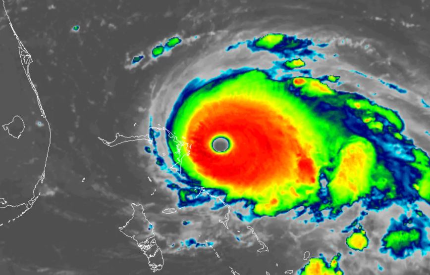
NEW: #NOAA20 captured this close-up of the eye of Category 5 #HurricaneDorian early this morning. @NHC_Atlantic now is describing this #hurricane as "catastrophic," and forecast to bring life-threatening storm surge, devastating winds to the northwestern #Bahamas. pic.twitter.com/Lkeb28c7xj
— NOAA Satellites PA (@NOAASatellitePA) September 1, 2019
Landfall in Florida Still Possible
After models run early Saturday shifted the storm track offshore Florida, some of them run late Saturday into early Sunday shifted it back closer to the Florida coast.
Because it would just take a small shift in Dorian’s track for hazardous winds to reach Florida’s east coast, a tropical storm warning was issued for the zone from Deerfield Beach, just north Fort Lauderdale, to Sebastian Inlet, just south of Melbourne.
While most models keep Dorian offshore Florida, the Hurricane Center wrote in its 5 a.m. Sunday advisory that a track near the coast or even landfall in Florida remain possibilities.
If the storm makes a close pass to Florida, tropical-storm-force winds could arrive as soon as Sunday night or early Monday morning. Because the storm is predicted to be a slow mover, effects from wind, rain and storm surge — could be prolonged, lingering through the middle of next week.
The Threat to Florida and the Southeast
Irrespective of the storm’s ultimate course near Florida’s east coast to the North Carolina Outer Banks — or even inland — significant coastal flooding is likely because of the force of Dorian’s winds and astronomically high or king tides.
The risk of a direct strike on Florida is less than it was a few days ago, but has not been completely eliminated. Much depends on the strength of the high pressure area that has been pushing Dorian west toward the northern Bahamas and Florida.
Most models show steering currents collapsing as Dorian nears Florida due to a weakening of the high, before it gets scooped up by a dip in the jet stream approaching the East Coast and starts turning north.
However, this collapse in steering currents is so close to Florida that some models continue to track the storm close enough for damaging impacts in parts of the state. One trend in the models overnight on Saturday and Sunday morning has been to show a slightly stronger high that brings the center of Dorian further west, closer to the Florida coast and the Southeast coast, before making the northward turn.
However, a few models do bring it inland or come perilously close. And there is time for the models to shift further — either closer to Florida and the Carolinas or further out to sea.
Georgia and the Carolinas
Farther north into coastal Georgia and the Carolinas, the forecast is also a nail-biter. Just small differences in where the storm starts to turn north and eventually northeast and the shape of the turn will determine where and whether Dorian makes landfall.
Scenarios involving a direct hit, a graze and a near miss appear equally likely based on available forecasts. As the Hurricane Center writes: “Residents in these areas should continue to monitor the progress of Dorian.”
The shape of the coastline from northern Florida through the Carolinas means there is a risk of significant storm-surge flooding there even if the storm’s center remains just offshore.
However, unlike with notorious recent storms like Matthew and Florence, it’s unlikely the Carolinas will see devastating rainfall amounts from Hurricane Dorian, as the storm will be picking up forward speed as it nears the Carolinas.
So be ready for Hurricane Dorian… You want to have the last home standing on the beach!


