If you thought tornadoes were just flying houses in The Wizard of Oz, think again. The United States is the undisputed tornado capital of planet Earth, home to more twisters than the rest of the world combined. And because Americans love branding even natural disasters, the most twister-prone zones have their own nicknames: Tornado Alley, Dixie Alley, Hoosier Alley, and Carolina Alley.
Let’s dive into the maps—and some mind-blowing tornado facts—that show where the atmosphere really wants to eat your roof for lunch.
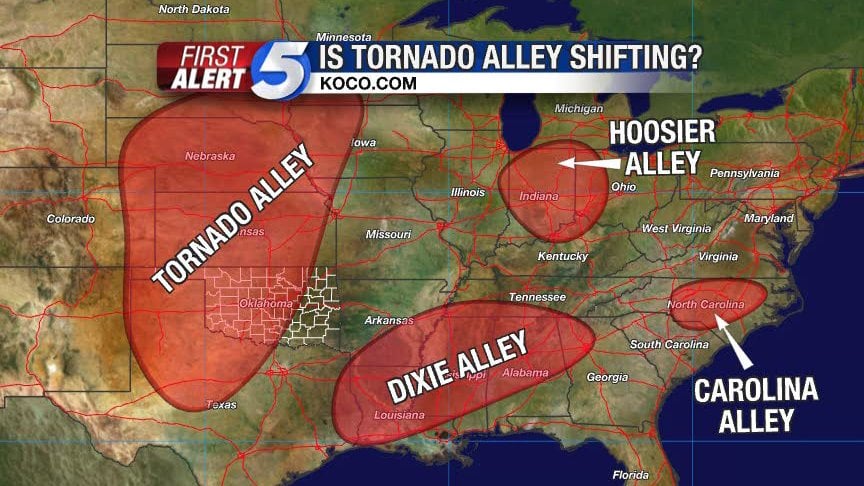
What Is Tornado Alley—and Where Is It Exactly?
Classic Tornado Alley runs through the Great Plains, covering Texas, Oklahoma, Kansas, Nebraska, eastern Colorado, and South Dakota.
What makes this strip of land so unlucky? It’s the perfect weather battlefield:
-
Warm, moist air surges north from the Gulf of Mexico.
-
Dry desert air drifts in from the Southwest.
-
Cold air crashes down from Canada and the Rockies.
-
Add the jet stream as the stir stick.
Result = violent supercell thunderstorms and twisters powerful enough to rip asphalt off roads.
⏱️ Peak tornado season here: April–June, with occasional fall surprises. Sometimes the sky turns green prior a tornado.

Dixie Alley: A Deadlier Tornado Zone
Dixie Alley spans Mississippi, Alabama, Louisiana, Tennessee, Arkansas, and Georgia.
Why is it worse than Tornado Alley?
-
Tornadoes often hit at night, while people are sleeping.
-
Thick forests and hills block visibility.
-
Higher population density = more targets.
💀 Fact: Some of America’s deadliest tornado outbreaks—like the 2011 Super Outbreak (360 tornadoes in 21 states, killing 324 people)—happened in Dixie Alley.
⏱️ Peak tornado season here: October–December.
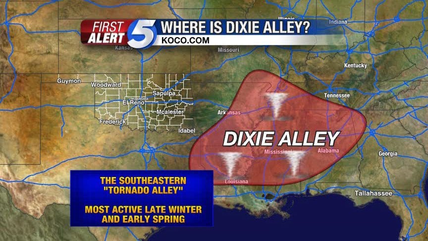
Other Tornado Alley You Didn’t Know Existed: Hoosier and Carolina Alley
-
Hoosier Alley → Indiana, Illinois, Ohio.
-
Carolina Alley → North & South Carolina.
-
Florida → More tornadoes per square mile than any state! Most are weaker waterspouts spun up by thunderstorms or hurricanes.
⚡ Fun fact: Florida averages 66 tornadoes per year—but since most are EF-0s, they’re more likely to knock over your tiki bar than your house.
How Strong Do Tornadoes Get?
Tornadoes are ranked on the Enhanced Fujita (EF) scale:
-
EF-0: Shingles blown off.
-
EF-1: Roof damage, cars pushed off roads.
-
EF-2: Trees snapped, houses shifted from foundations.
-
EF-3: Severe damage, walls ripped away.
-
EF-4: Whole houses flattened.
-
EF-5: “Scorched earth” destruction—everything gone.
🌪️ Amazing fact: The strongest tornado winds ever measured reached over 300 mph during the 1999 Bridge Creek–Moore, Oklahoma EF-5 tornado. That’s faster than a Formula 1 car. The Super Outbreak on April 3, 1974 was one of the MOST violent tornado outbreak on records.
Tornado Intensity in the U.S.: How Bad Can It Get?
-
77% of U.S. tornadoes are weak (EF-0 to EF-1)
-
95% are below EF-3
-
The real menace: EF-3+ tornadoes—especially EF-5, capable of annihilation with winds over 200 mph.
On average, America sees 1,000+ tornadoes annually, about 20 violent tornadoes, and usually 1 severe EF-5—your odds aren’t great if you live in a hotspot.
Tornado Risk and Hazard Maps You Should Know
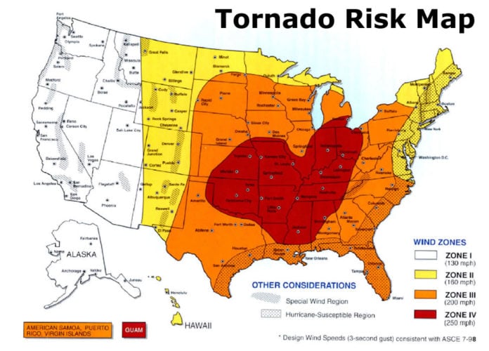
1. Tornado Risk Map (USA)
Visualizes high-risk zones in red. States like Oklahoma, Kansas, northern Texas, Alabama, and Mississippi = worst of the worst.
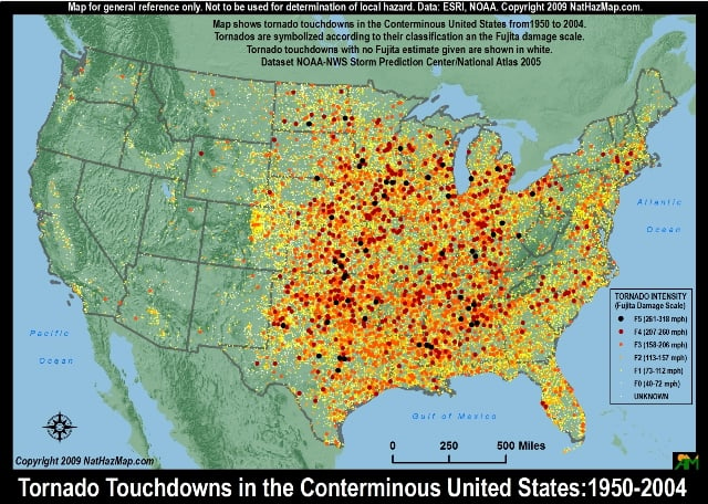
2. Tornado Hazard Map (1950–2004)
Displays where most deadly tornado touchdowns occurred over decades. Spoiler: the red zones look like someone spilled chili across the Plains and Southeast.
3. EF-3 and Up Tornado Frequency
Maps the most active areas for the strongest tornadoes in the U.S. So-called tornado “super hotspots.” These are the areas most likely to spawn monster EF-4s and EF-5s.

Tornado Alley Is Shifting East
Meteorologists have noticed something unsettling: Tornado Alley seems to be migrating eastward. States like Arkansas, Kentucky, and Tennessee are seeing more activity while the Plains see less. Scientists aren’t sure if it’s climate change, jet stream wobbling, or something else—but if you live there, congrats: you just got an upgrade in natural disaster risk.

FAQ — Twister Edition: Your Questions Answered
❓ Which states get hit with the most tornadoes?
Texas leads with ~140 tornadoes per year, but Florida has the highest tornado density (tornadoes per square mile). Basically: Texas gets more, Florida gets more often.
❓ Which states make up Tornado Alley?
Traditional boundaries include TX, OK, KS, NE, parts of CO, and SD—though some definitions stretch to IA, MO, and OH.
❓ How many tornadoes happen worldwide vs. the U.S.?
The U.S. averages 1,200 tornadoes annually. That’s more than every other country combined. Canada comes second with ~100 per year, while Europe gets just a handful.
❓ Can a tornado lift a cow (or a train)?
Yes. EF-4 and EF-5 tornadoes can fling cars like toys, rip asphalt off highways, and even derail trains. During the 1925 Tri-State Tornado, whole towns were erased from the map. And a few years ago, some cows were indeed swallowed up.
❓ What’s the deadliest U.S. tornado?
The 1925 Tri-State Tornado killed 695 people across Missouri, Illinois, and Indiana. It stayed on the ground for 219 miles—a record that still stands.
❓ Do tornadoes really make things “explode”?
Yes and no. Tornado pressure drops so rapidly that houses can literally “pop” if windows/doors are shut. But the bigger destruction comes from debris hitting at supersonic speeds.
❓ Is it true tornadoes can suck fish or frogs into the sky?
Yes—waterspouts and tornadoes crossing rivers have sucked up fish, frogs, and even turtles, later dropping them in nearby towns. Rain of animals is rare—but real.
❓ What’s scarier: Tornado Alley or Dixie Alley?
Depends. Tornado Alley has more tornadoes, but Dixie Alley has more deadly ones due to population density, terrain, and nighttime strikes. Statistically, you’re less likely to survive a Dixie Alley tornado.
Final Thought
Whether you’re in Tornado Alley, Dixie Alley, Florida, or the Carolinas—the maps show one truth: in the U.S., you’re never really safe from twisters.
So:
-
Keep your storm shelter stocked.
-
Buy decent insurance.
-
And maybe stop building entire suburbs on flat plains where the sky routinely throws 200 mph death funnels.
Support StrangeSounds
If you love doom maps and weird facts:
-
Paypal 💸
-
DonorBox 💳
-
Subscribe to the Strange Sounds’ Newsletter for your daily doom and gloom




Having grown up in Illinois tornado season is just a reality of life. I am at once wary and fascinated by tornadoes.
[…] Here a map of the tornado alleys in the USA. […]
[…] more about tornado alleys and where they are […]
[…] Discover a map of tornado alleys in the USA! […]