More than a half-million people in the Northeast woke up to darkness on Thursday, as an unseasonably strong Nor’easter slammed the region with rain and high winds.
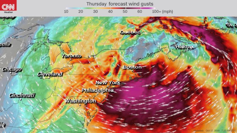
Utility poles snapped, cruise ships sought shelter, boats broke from their moorings, trees were uprooted, and more than 500,000 customers in New England were without power early Thursday as the bombogenesis with winds gusting up to 90 miles an hour swept up the East Coast.

The bomb cyclone is now parked over southern New England with the pressure equivalent to a Category 2 hurricane and promises to disrupt travel in the region through the end of the workweek.
Bomb cyclone slams the East Coast. @WhitJohnson is in Massachusetts with the latest. https://t.co/wUGutNCzft pic.twitter.com/bfGuUDbNcZ
— Good Morning America (@GMA) October 17, 2019
The pressure of the bombogenesis dropped 24 millibars in just 14 hours — and plummeted 35 millibars over 24 hours. The system broke low-pressure records for October in Boston; Providence, Rhode Island; Hartford, Connecticut; and Portland.
Have you ever wondered what meteorologists mean by the term "bombogenesis"?
— Pattrn (@pattrn) October 17, 2019
This rapidly intensifying midlatitude "bomb cyclone" gets its name from when barometric pressure drops 24 or more millibars over 24 hours, producing extreme storms. pic.twitter.com/ayJGcCZy24
The storm’s heaviest rain fell in upstate New York, where up to 5 inches was recorded. The Mid-Atlantic states and much of the Northeast got 1 to 2 inches of rain.
Bombogenesis Triggers Widespread Power Outages And Plane Cancelations
More than 550,000 customers in New England are without electricity Thursday’s morning.
@newscentermaine out side at 5:30 pic.twitter.com/k4Dg4FCl9k
— Colby Thomas (@ColbyTh38819456) October 17, 2019
- Over 225,000 households and businesses in Massachusetts were in the dark on Thursday morning.
- In Maine, more than 196,000 households and businesses were without power Thursday morning, while in New York the number was about 41,000.
As the sun comes up DXFD continues to respond to many #weather related emergencies. Please remember to treat any downed wires as LIVE and call 911. If you don’t need to be out driving please don’t. Many streets remain closed. #DXFD pic.twitter.com/tKuwXJSxF4
— Duxbury Fire PIO (@DXFD_PIO) October 17, 2019
At least 50 flights have been canceled Thursday at Boston Logan International Airport, FlightAware.com reports, with more delays and cancellations expected through late Friday.
Powerful Winds and Rain
Wind gusts of 40 to 50 mph are expected to punish New England for much of Thursday.
Crazy. This trampoline bounced through a fence on Dillingham Ave. Falmouth. pic.twitter.com/6XZpVygVwL
— George Brennan (@gpb227) October 17, 2019
- Provincetown, on Massachusetts’ Cape Cod, already has been lashed with winds of 90 mph.
- Boston Logan recorded gusts of 70 mph overnight into Thursday.
- Gusts atop Mount Washington in New Hampshire were clocked at 125 mph.
- New York City, Boston and Portland, Maine, may feel winds of at least 39 mph.
The bomb cyclone is the second coastal storm to impact New England in a week. Last week’s storm sat off the coast of the Mid-Atlantic, churning up seas and bringing a strong onshore wind that shredded beaches up and down the East Coast. It caused costly damage due to beach erosion and coastal flooding. [CNN, KTLA, NYT, FlightAware]


