Severe thunderstorms disrupted Halloween plans for millions of people Thursday night as a strong cold front raced through the East, downing trees, knocking out power and leading to water rescues from flash flooding.
This was the most severe reports in any 24-hour period in the U.S. since June 30.
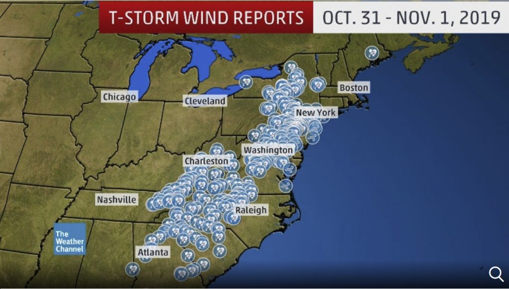
An intense line of thunderstorms moved across the eastern U.S. on Thursday night.
As of early Friday morning, more than 300 preliminary reports of severe weather had been received by the NOAA/NWS Storm Prediction Center.
The high winds knocked out power to as many as 860,000 customers in 14 states from Michigan to Virginia to Maine by early Friday morning, according to poweroutage.us.
Neighbors in this part of Glen Mills, Delaware County say the late-Halloween storm rolled in like a freight train. For 30-60 seconds winds shook their homes, ceilings and roofs collapsed, trees down — but no serious injuries reported @NBCPhiladelphia pic.twitter.com/usgxiy8FnP
— Randy Gyllenhaal (@RandyGyllenhaal) November 1, 2019
Across the border in Canada, some 900,000 customers of Hydro-Quebec have lost power due to high winds.
Friday, New York Governor Andrew Cuomo issued a state of emergency for 11 counties due to damage from the storm.
Eleven counties will be getting a state of emergency declared after last night’s storms, Cuomo says: Cayuga, Chautauqua, Dutchess, Erie, Essex, Hamilton, Herkimer, Montgomery, Oneida, Saratoga and Warren.
— Nick Reisman (@NickReisman) November 1, 2019
Heavy rain resulted in numerous road closures, washouts and residents trapped in homes and cars in parts of central and Upstate New York, according to the National Weather Service in Albany.
A flash flood emergency was issued Friday morning for the village of Frankfort in southern Herkimer County, New York, with evacuations requested along Moyer Creek.
Flash Flood Emergency including Frankfort NY until 11:30 AM EDT pic.twitter.com/A0ANNzI5BB
— NWS Albany (@NWSAlbany) November 1, 2019
In the nearby town of Fairfield, swiftwater rescues were ongoing Friday morning, with roads and a bridge washed out.
Twenty-five roads were washed out near Johnsburg, about 65 miles north-northwest of Albany.
Just west of Glens Falls, New York, the Hudson River flooded a street in Lake Luzerne, prompting evacuations.
Radar-estimated rainfall ranged from at least 2 inches in parts of eastern Pennsylvania to as much as 5 inches in eastern New York.
Records Crests
Just after midnight, water levels on West Canada Creek at Hinckley Dam and at Kast Bridge just north and east of Utica, New York, topped all-time record crests in both locations.
The Sacandaga River at Hope, New York, also topped its record crest from 1981 during the storm.
The Mohawk River at Little Falls, New York, nudged just above its previous record crest from 2006 early Friday morning.
Several mudslides were reported, with one closing State Route 200 between Ulster and Towanda, PA and another blocking Route 5S near Frankfort, NY.
Earlier tonight part of State Route 220 from Ulster to Towanda, Pa was blocked off for more than an hour due to major flooding and a reported mudslide. https://t.co/C2D7cNHkkf
— Ashley Cafaro (@WENYAshleyC) November 1, 2019
At 10:56 PM EDT, Frankfort [Herkimer Co, NY] LAW ENFORCEMENT reports FLASH FLOOD. ONGOING FLOODING WITH RT. 5S CLOSED DUE TO MUDSLIDE AROUND CULVERT AVE. https://t.co/sZcfuEpkL9
— IEMBot ALY (@iembot_aly) November 1, 2019
Serious flooding was also reported in parts of northern Vermont, closing numerous stretches of roads.
The Missisquoi River at North Troy, Vermont, near the Canadian border, topped its previous record crest from June 2002.
Water levels along the Lamoille River was expected to produce extensive flooding in Jeffersonville and Johnson, Vermont, inundating homes and businesses, according to the National Weather Service.
High Winds and Tornadoes
Widespread high winds brought down trees from Georgia to New England Thursday and Thursday night.
Based on radar indications, multiple tornado warnings were issued Thursday night into early Friday, including one for the Philadelphia area. A tornado debris signature was evident on radar near Radnor, PA.
It doesn’t get more clear than this. Tornado warning just issued. TDS just southwest of Radnor, PA. #pawx pic.twitter.com/0NlpjSWRnm
— John Homenuk (@jhomenuk) November 1, 2019
A National Weather Service damage survey Friday morning confirmed EF2 tornado damage in Delaware County near Glen Mills. At least eight homes in Thornbury Township west of Philadelphia were damaged, according to WPVI-TV.
Police in Horsham Township, PA, urged residents to stay off the roads until further notice. “We have trees and debris down all over the township.”
Behind the cold front, strong winds downed trees in Buffalo, New York, blocking 20 city streets.
Update from City of Buffalo:
— Jeff Slawson (@Jeffslawson) November 1, 2019
20 streets blocked due to downed trees
12 traffic signals out or flashing due to wind
No injuries reported at this time @WKBW
High winds blowing over Lake Erie lead to lakeshore flooding, prompting the closure of a stretch of route 5 south of downtown Buffalo early Friday morning. These persistent winds induced a seiche, a sloshing of the lake’s water from west to east and back again.
As pointed out by @TomNiziol, a textbook Lake Erie #seiche. Note water levels bottom out near Toledo, OH, then rose. At the same time they peaked at Buffalo, NY, then fell. Like your kid sloshing water in a bathtub. Also happening on Lake Ontario. pic.twitter.com/JolXnGKLp4
— Jonathan Erdman (@wxjerdman) November 1, 2019
Homes were flooded along the north shore of Lake Erie between Dunnville and Port Colbourne, Ontario, early Friday, according to The Weather Network. Similar lakeshore flooding was also reported along the eastern side of Lake Ontario in Oswego, New York, early Friday.
Lakeshore FLOODING has started east of Lake Ontario.
— Peter Hall (@PeteWeatherBeat) November 1, 2019
This is in Oswego via @marykielarCNY
Further flooding near and east of Lake Ontario near the shoreline will be likely in spots due to HIGH winds piling up HIGH waves and pushing water onshore (seiche, like storm surge)#NYwx pic.twitter.com/AbugsmBXJi
It seems that the U.S weather is going crazy these days with devastating fires in California, a Pineapple Express in Alaska, the continuous flooding along the Missouri River and this insane weaponized lightning that created a huge crater in Fort Worth, Texas. [The Weather Network]


 in 3 days of storm")


