Axial Seamount, situated off Oregon’s coast, is one of the most active, and also one of the most studied submarine volcanoes on the planet.
This summer scientists set sail on a perilous expedition to create the first internal 3D images of the underwater volcano deep in the Pacific Ocean and predicted its next eruption will happen within the next 5 years.
Most people interested in volcanology know at least one volcano in Oregon: Mt. Hood. It just made the headlines due to a new earthquake fault line discovered on its flank.
There are also Mt. Mazama in Crater Lake National Park and Newberry Volcano in Bend… But have you ever heard of Axial Seamount, a huge underwater volcano 300 miles off the coast of Oregon?
Scientists at least do and are studying the active submarine magma monster for years.
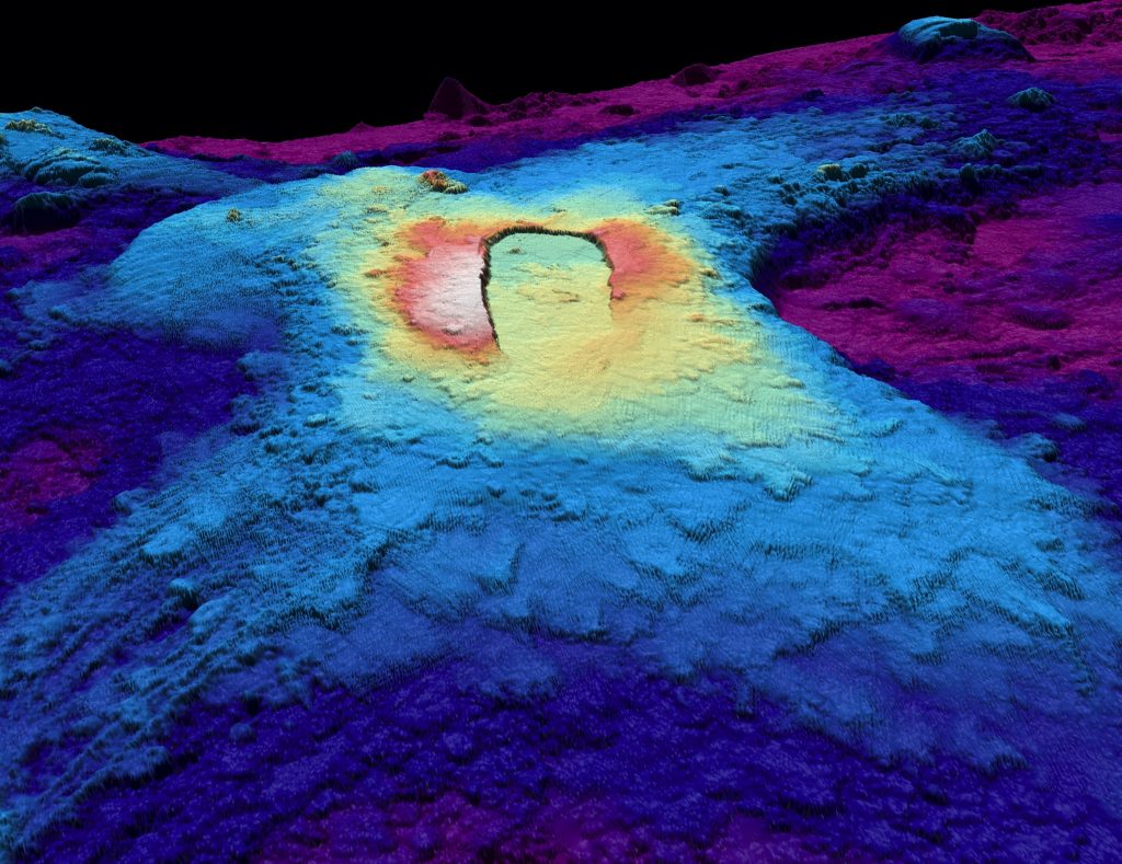
And this summer, sailing the 235-foot research vessel Marcus G. Langseth from the National Science Foundation, they took a voyage out to sea to 3D scan the volcano in all its glorious detail for the very first time.
Information About the Axial Seamont Underwater Volcano
The Axial Seamount sits 300 miles off the coast of Oregon and it’s base is so large it would cover the entire city of Austin, Texas.
Although not the biggest submarine volcanic mount around the world, the main magma reservoir is two-thirds of the length of Manhattan, the same width, and taller than any building in the city.
Axial is the youngest volcano of the Cobb-Eickelberg seamount chain, a 1,120-mile-long line of submarine volcanoes created by a stationary mantle plume below the shifting Pacific tectonic plate.
Axial seamount currently sits atop that hotspot and also astride the mid-ocean ridge separating the Pacific plate to the west and the Juan de Fuca plate to the east, which are moving apart.
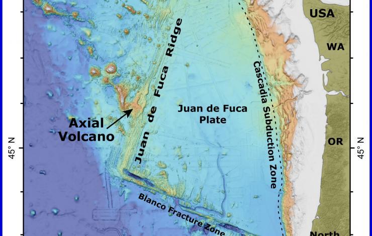
These two forces help make Axial the most active submarine volcano in the region. So far, three eruptions — in 1998, 2011 and 2015 — have been documented as they occurred. But don’t worry, it was erupting long before humans spotted it.
Although its eruptions will ‘never’ cause anyone harm, Axial is one of the most comprehensively researched and monitored submarine volcanoes in the world.
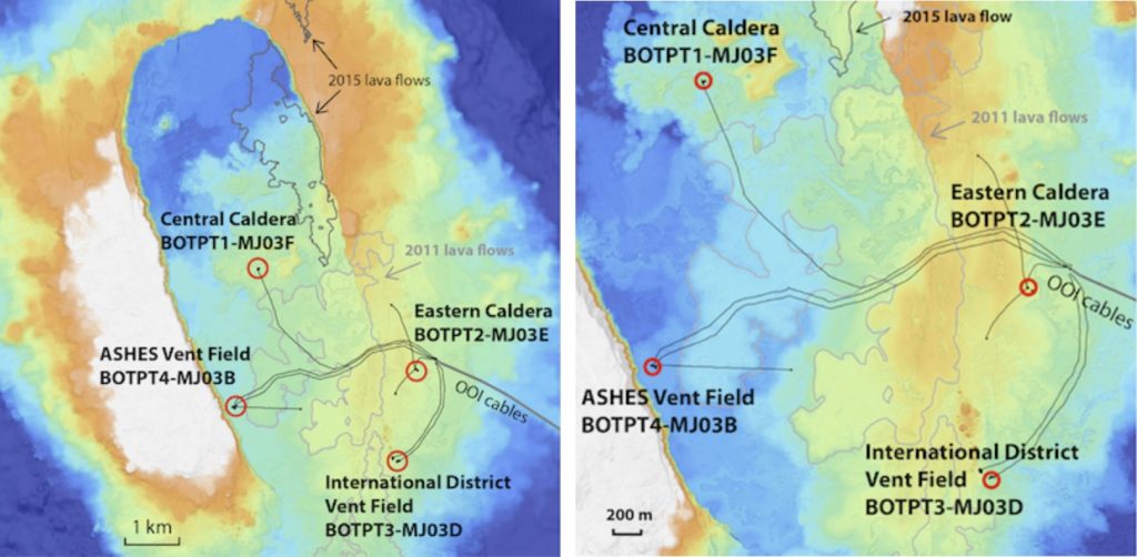
Axial Seamount is home to the world’s first underwater volcano observatory NeMo and since late 2014, is continuously monitored by an underwater observatory network known as the Cabled Array.
Its better monitoring and comprehension could help diminish hazards at other volcanoes that do pose risks for the surrounding population.
When Is The Next Eruption of Axial Seamount?
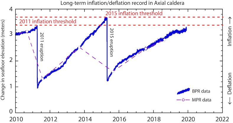
As you can see on the plot above, the rate of inflation at Axial Seamount has abruptly decreased, pushing back the forecast window for the next eruption from 2020-2022 to 2020-2024.
Since the latest 2015 eruption, Axial has already re-inflated almost 2.0m (or ~80%) of the 2.5m it deflated. Such calculations are based using data from the OOI Cabled Array as shown below:
According to the next video, there are a bunch of submarine volcanoes around the world.
Understanding Axial Seamount could help us protect populations at risk. And that’s very important. If you want more preparedness news headlines, continue reading this blog or visit Steve Quayle. [NOAA, NYTimes]


An expanding nuclear waste dump under the ocean floor may look similar. Experts know
WHY are freeks so popular now days,LIKE THE ONE IN THE VIDEO,he has a beard,but shaves his head,THAT, KIDS IS MONKEY SEE, MONKEY DO,these people are to far gone to listen to,yet you love them,AMERICA has truely lost their mind,THE WHOLE COUNTRY IS BECOMING MENTILTY UNBALANCED.this leads to WARS and MASS death,DO ANY OF YOU UNDERSTAND???
If you drill down in Google Earth you will not see Axial Seamount, because it isn’t there, you have to follow the topography to see where they are assessing where the volcano is which is labeled Juan De Fuca Ridge with the close by Brown Bear Sea Mount. I have looked and look for Axial and have not seen it labeled as such. Anyone have any ideas why this is the case?
Here’s what you do – use this Google search term “Axial Seamount”.
Now click on the Wikipedia site, and look in the upper left corner for the link – “coordinates”
Click on that link and it will take you to the – “GeoHack – Axial Seamount” page.
Scroll down until you find the “Google Maps link”
Click that and there you go.
Or just enter these coordinates into a Google maps search – “46.06,-130”