Did you know there is a supervolcano in Ecuador?
And scientists are frequently asked if the Chalupas volcano, located southeast of Cotopaxi, will erupt in a way that could wipe Ecuador off the map.

Where is the Chalupas located?
Chalupas is located between the provinces of Napo and Cotopaxi, approximately 80 km southeast of Quito and 35 km northeast of the city of Latacunga.

It is located on the crest of the Cordillera Real of the Ecuadorian Andes and its name comes from the Chalupas River that flows in the southern part of the volcano.
What type of volcano is the Chalupas?
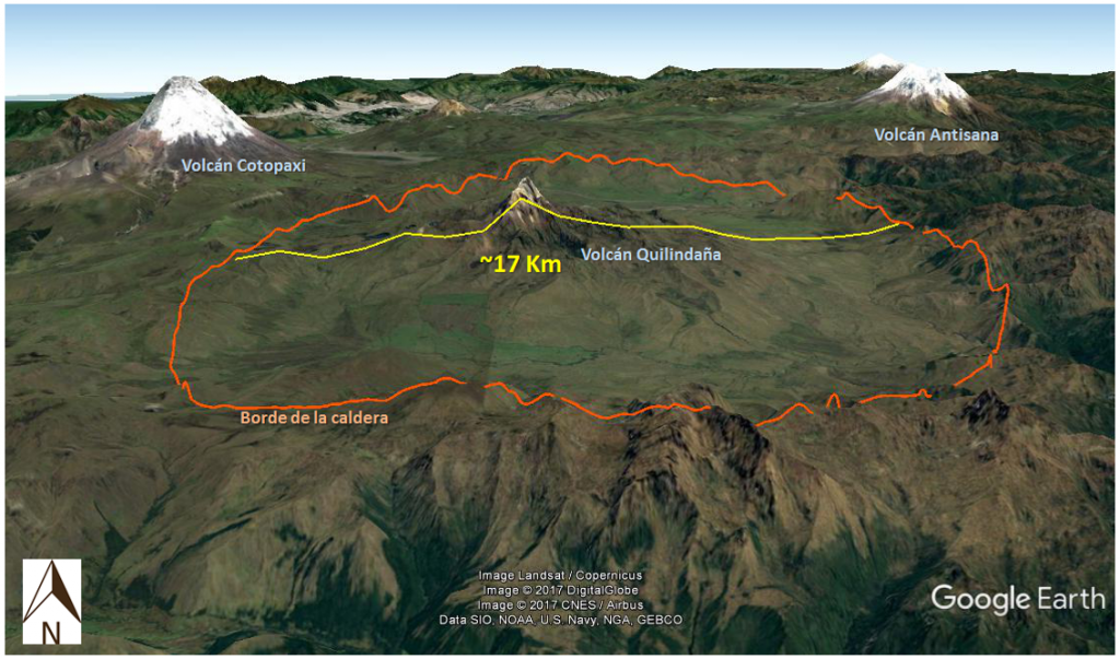
El Chalupas is an ancient volcano. Today, his remains are found only on the edge of a large depression called the caldera.
Geological evidence suggests that, prior to the formation of the caldera, there was an accumulation of closely together eruptive centers that must have erupted simultaneously to generate the collapse (Córdova, 2018).

The most notable structure of this volcano is then its caldera, which corresponds to an elliptical depression approximately 17 km in diameter and which was discovered in 1979 by the Spanish geologist José Manuel Navarro (INECEL, 1983).
In the center of the caldera rises the Quilindaña stratovolcano (4878 m).
How and when did the Chalupas caldera formed?
The Chalupas caldera was formed during a gigantic explosive eruption during which a very large volume of magma with more than 70% silica was ejected.
After evacuating so much magma in such a short time, the ceiling of the magmatic reservoir collapsed leaving a depression in the surface.
The Chalupas eruption occurred approximately 216,000 years ago (Bablon et al., 2020).

How big was the eruption?
The eruption was very large and left two deposits. The easiest to recognize is a pyroclastic flow deposit (hot cloud of gas, ash and pumice that descends from the volcano) near the caldera and in the Inter-Andean Valley. It can be found from Riobamba in the south to Tumbaco in the north and reaches thicknesses of up to 200 m near Latacunga.
That type of deposit, due to its characteristics and its way of formation, is called an ignimbrite. According to the recent study by Bablon and co-authors (2020), the Chalupas ignimbrite covers an approximate surface of 3150 km² and has an average thickness of 25-35 m, which allows its volume to be estimated between 80-110 km³.
The other deposit of this eruption is a layer of ash found on the Ecuadorian coast and between sediments at the bottom of the sea. This deposit is associated with a huge ash cloud formed from the ignimbrite and is classified as a co-ignimbrite.
The co-ignimbrite covers a much larger area than the ignimbrite but with a much smaller thickness. The 1 cm isopic, that is, the area that is more than 1 cm thick, covers 1.6 million km², equivalent to 6 times the surface of Ecuador. According to Bablon et al. (2020), the co-ignimbrite has an approximate volume of 120-155 km³.

VEI7 Super Colossal Eruption
The total volume of the deposits of the Chalupas eruption is estimated between 200 and 265 km³, which represents a cube of more than 6 km on each side.
Due to its volume of deposits, it is classified with a volcanic explosive index (VEI) of 7. In comparison, the Reventador eruption in 2002, the largest in Ecuador in the last century, had a VEI of 4 with a volume almost 700 times lower.
With a VEI of 7, the Chalupas eruption is considered ultra-plinian or super-colossal.
This type of eruptions rarely occurs on a world scale, every 500 to 1000 years; and the last one was the eruption of the Tambora volcano in 1815.
Is the Chalupas volcano active?
Chalupas is the name of the ancient volcano that collapsed after a great eruption 216,000 years ago.
The new volcano that formed in the Chalupas caldera is the Quilindaña, a stratovolcano with a mainly effusive activity (with lava flows and domes).
The last eruption of the Quilindaña was before the last ice age, that is to say more than 11,700 years ago, and it does not present seismic activity or deformation today. For these reasons it is considered extinct or at rest.

Is a novel Chalupas super-colossal eruption possible?
Volcanoes that make repeated super- or mega-colossal eruptions are sometimes referred to as super- or mega-volcanoes.
Yellowstone is a known example with three super- to mega-colossal eruptions in the last 2,100,000 years.
The last Chalupas eruption was the only super-colossal of the volcano and probably the only one of this size in Ecuador in the entire Quaternary – or in the last 2,600,000 years.
Chalupas is not like Yellowstone, and may never make a super-colossal eruption again. And like Yellowstone, if Chalupas were to erupt, it would most probably be an effusive eruption of the Quilindaña volcano and, thus, would not have a major impact on a regional scale.
By the way you can learn more about U.S. Calderas in the following documentary (click on the image below).
This article was first published in Spanish on the Ceniza-Ecuador blog by Marco D. Córdova and Benjamin Bernard (IG-EPN) – highly recommended for in-depth information about Ecuador volcanoes. More volcanic news on Strange Sounds and Steve Quayle.


Every week its a different “super volcano” that’s going to destroy earth and it’s always “imminent” !! As always with Steve Quayle this could be “the BIG one” that destroys earth so remember to by your precious metals from Renaissance Precious Metals before the earth is destroyed !!
.
As bad as Jim Baker and Kenneth Copeland, the world’s going to end so send me your money before it does.
Sensational tabloid chicken little reporting can never be trusted. There are always underlying intentions. However, there have been some interesting events in past history. Research the 535 AD Event. It’s a geological and historical fact.
If you are interested in this stuff then study the “535 AD event” which changed the climate, started plagues, and brought down Empires.