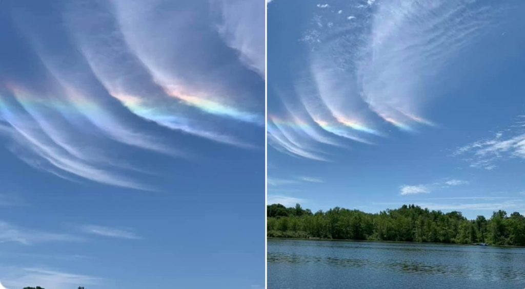
Tropical Depression Cristobal made a rare landfall on the Great Lakes yesterday…
Because 2020 is just filled with weather surprises.

After the third derecho storm in history swept across Colorado and Wyoming last weekend, Tropical Depression Cristobal began crossing over Lake Superior earlier Wednesday morning, the first known case of this ever happening.
From #Mexico to … Moosonee?! #NotSomethingYouSeeEveryDay #Cristobal pic.twitter.com/EFAhT64U5c
— Stu Ostro (@StuOstro) June 10, 2020
Yes, what’s left of Cristobal has survived its long trek up the Mississippi River Valley, causing widespread flooding. And now, it is heading into Canada as an extra-tropical storm, bringing widespread thunderstorms to the Great Lakes region.
Cristobal Cloud Iridescence! High clouds straight from the tropical system itself! ?
— Erik Kostrzewa (@FOX17Erik) June 10, 2020
These clouds were captured over Middle Lake in Barry County by Tina Knickerbocker! @StormHour @ThePhotoHour pic.twitter.com/9YThch8PSC
“As the remnants of Cristobal lifts very quickly to the north, the system will bring strong severe storms to portions of the Great Lakes, more specifically Michigan and Ohio this afternoon,” CNN meteorologist Haley Brink says. “Due to the speed of this system, severe damaging winds may be the more widespread threat through the afternoon and evening hours, with tornadoes also possible.“
#Cristobal will accelerate north through Wednesday. Heavy rain and gusty winds will remain a threat especially across Wisconsin and the Great Lakes. Severe thunderstorms are possible Wednesday from Ohio and lower Michigan into parts of Pennsylvania, West Virginia, and New York. pic.twitter.com/aWBJIEsWIs
— National Weather Service (@NWS) June 10, 2020
Cristobal’s remnants are providing a very moist environment for these storms to thrive. And with an advancing cold front right on its heels, the two systems will clash and bring tropical-like storms to the region and a line of strong storms associated with the advancing cold front.
The ‘Windy City’ became the ‘Wet and Windy City’ on Tuesday, as the remnants of what was Tropical Storm #Cristobal crossed the area ? ? pic.twitter.com/Kfs5K6OBsX
— BBC Weather (@bbcweather) June 11, 2020
The Storm Prediction Center has issued a moderate risk – level 4 of 5 – for severe thunderstorms, including tornadoes for Wednesday afternoon and tonight. Over 8 million people are in this risk area, including much of eastern Michigan and northwest Ohio. A level 3 of 5, enhanced risk cover much of the rest of Ohio, Michigan and into parts of Indiana.
Ohio
Almost 100,000 people were left in the dark in northeast Ohio as a turbulent, 60 mph squall line swept across the region.
The State Theatre in Sandusky, Ohio has been destroyed; watch the theatre collapse below:
A mammoth rainbow was seen Wednesday evening across Parma and Cleveland’s West Side after the storm passed:
Wow! Look what came out – AFTER – the storms rolled through! pic.twitter.com/ZROHslx8yn
— Jason Nicholas (@JasonNweather) June 11, 2020
Michigan
About 288,000 customers are still without power early Thursday after severe thunderstorms hit mid- and southwest Michigan, bringing hail and wind gusts up to 70 mph.
The National Weather Service has issued a Beach Hazards statement for a long stretch of Lake Michigan shoreline.
High wave action, strong currents and dangerous swimming conditions are expected beginning late tonight and through Thursday night at beaches in Mason, Oceana, Muskegon, Ottawa, Allegan and Van Buren counties.
A Gale Warning for all of Lake Michigan’s open water goes into effect at 7 p.m. tonight. Southeast winds up to 34 mph are forecast, with gusts up to 40 mph, according to the NWS. This will produce waves of 7 to 10 feet.
NWS meteorologists have this advice for anyone venturing out to the beach in the next couple days: “Remain out of the water to avoid hazardous swimming conditions and do not venture out on piers. Please check with your local authorities on potential beach closures.”
Cristobal weakened into a depression early Monday after inundating coastal Louisiana and ginning up dangerous weather along most of the U.S. Gulf Coast, sending waves crashing over Mississippi beaches, swamping parts of an Alabama island town and spawning a tornado in Florida. Conditions will improve dramatically by Thursday, with humidity levels coming down and the sunshine returning.
More extreme weather on Strange Sounds and Steve Quayle. [KRDV, WCSG, Cleveland19, Detroit News]


I have told you my predictions super storms will bring mankind to its knees. Unless all form of prejudices are not abolishes from face of planet we will have Mogadishu in all nations?
I want good for all what is wrong with that. If your brother good job will bring you also to the company. Let see these agent of Ayatollahs how many days can take over the 6 blocks in my
Seattle? I think they will leave in week at most unless more money and food are put in to hands of them by Hezbollah and Iran terrorist Gov? Strange sounds i was thinking are they ISIS same way want money for protections? Capon in Chicago? Last 4th of July we had
ISIS member close to white house and got photo of it under neat said we will capture white house? We killed the head of ISIS in Iraq and they have oil money and still regrouping .
We know fact open borders that Donald Trump said we build wall not yet, caused more ISIS
terrorist come to USA and guide all riots and destruction of USA. What do you think global readers of Strange sounds?