Powerful thunderstorms consolidated over the D.C. area Thursday evening, releasing a dramatic and memorable outburst of thunder and lightning while also dispensing tremendous rainfall.
Energized by stifling heat and humidity, it was the fourth day in a row of vigorous summer storms in some locations.

Eyewitnesses described the jarring claps of thunder and the strobe-light-like lightning display as among the most extreme they had seen:
[T]hat was some of the loudest, sustained thunder and lightning I’ve ever been through.
@capitalweather that was some of the loudest, sustained thunder and lightning I’ve ever been through. In Hyattsville MD.
— Jim Groves (@jgroves) July 24, 2020
I’ve never seen an electrical storm like this:
The #lightning in #WashingtonDC tonight is endless! I’ve never seen an electrical storm like this. Extremely dangerous! It has been doing this for more than 30 minutes⚡️ #DCwx @weatherchannel @AMHQ @wunderground pic.twitter.com/Wjm1LxDCHD
— Justin Michaels (@JMichaelsNews) July 24, 2020
I’m not prone to hyperbole but this takes the cake for the most intense lightning event since the derecho:
I’m not prone to hyperbole but this takes the cake for the most intense lightning event since the derecho
— Dave Dildine (@DildineWTOP) July 24, 2020
The storms prematurely ended the Nationals home opener against the Yankees, as sheets of rain enveloped the ballpark and flashes of lightning lit up the sky.
More than 125,000 lightnings in 2 hours
The D.C. Lightning Mapping array detected 126,500 instances of lightning discharge between 8 and 10 p.m. From 8:21 to 8:55 p.m., there were nearly 3,000 lightning events within eight miles of Nationals Park said Chris Vagasky, a lightning expert for the Vaisala Group, which operates the National Lightning Detection Network.
Nearly 3000 #lightning events within 8 miles of @Nationals Park between 8:21 and 8:55pm when the game was delayed because of rain. #DCwx @MLB Another disappointing display of #LightningSafety https://t.co/XOaK5S7ZYU pic.twitter.com/OsiLtOBR2X
— Ch☈is Vagas|☇y (@COweatherman) July 24, 2020
A hot and abnormally humid air mass fueled the storms, which formed as a subtle disturbance in the atmosphere’s flow transited the region.
The storm that inundated D.C. was part of a localized transient cluster of cells that merged with a separate, rapidly developing cluster arriving from the west and southwest. Thunderstorm cell mergers have been shown to produce extreme weather.
The merging of separate masses of cloud water and ice may have super-electrified the cloud system. In the graphic below, note the extremely concentrated nature of the lightning discharges, from 8 to 10 p.m.
Most of the 125,000-plus detectable electrical “sources” in that two-hour period were contained high within the cloud system. This suggests tremendous amounts of lofted water and ice in cloud updrafts. The combination of water and ice, within a turbulent updraft, is the leading hypothesis for initiating electrical charge.
Here are the storms you can blame for the rain delay.
— Dakota Smith (@weatherdak) July 24, 2020
Lotta lightning in DC. pic.twitter.com/r7Q3keMK4w
Unprecedented storms
The vigor of those updrafts can be explained by a small pocket of very unstable air feeding into the storm cluster. An analysis of the convective available potential energy (CAPE — a measure of updraft buoyant energy) in this two-hour time period revealed values in the 3,000 to 3,500 Joules per kilogram range feeding into the storm from the south and east of the District. It takes about 1,000 J/kg to initiate a garden-variety thunderstorm; so the values feeding the D.C. cells were three times this threshold!
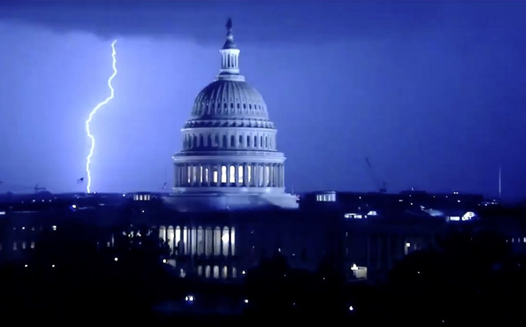
Easily the best photo I’ve ever taken but the symbolism may be too heavy handed @capitalweather @PoPville pic.twitter.com/92jM66msj9
— Adam (@AdamG_MB) July 24, 2020
The storms unloaded torrential rainfall, falling at a rate of over three inches an hour in some areas. Reagan National Airport picked up 1.79 inches in just 30 minutes between 9 and 10 p.m. (and 1.89 inches overall). The National Weather Service received more than a half-dozen reports of flooding focused in Arlington, Alexandria, the District, and Oxon Hill as well as Prince William County.
WOW! The view from our roof-cam tonight during the most intense lightning storm I’ve seen here in years. #Weather #storm #Lightning pic.twitter.com/D6KDNxxwxD
— Scott Thuman (@ScottThuman) July 24, 2020
The torrents inundated roadways, stranding cars in high water in several locations.
While instances of damaging winds were sporadic, the Weather Service received several reports of downed trees in the eastern part of the District and adjacent areas of Prince George’s County. Andrews Air Force Base clocked a wind gust of 58 mph.
Nature is entertaining us while we are stuck in our houses. pic.twitter.com/CJesbm6PaH
— Michael Franzinger (@mike_franzinger) July 24, 2020
For storm photographers, the barrage of lightning offered an ideal opportunity to capture dramatic imagery.
The #lightning in #WashingtonDC tonight is endless! I’ve never seen an electrical storm like this. Extremely dangerous! It has been doing this for more than 30 minutes⚡️ #DCwx @weatherchannel @AMHQ @wunderground pic.twitter.com/Wjm1LxDCHD
— Justin Michaels (@JMichaelsNews) July 24, 2020
“I was in the Jefferson Memorial watching the rain shafts form on the western horizon,” Capital Weather Gang photographer Kevin Ambrose said. “Initially, I didn’t see much lightning. But when the storms approached and moved over Arlington, suddenly lightning began to flash frequently.“
Lightning compilation from last night. @hhowardWTOP @wtop @capitalweather @dougkammerer @hbwx @suepalkafox5dc @SteveRudinABC7 @ARLnowDOTcom #Lightning pic.twitter.com/nhmTqWYDaB
— Dave Statter (@STATter911) July 24, 2020
“When the storms moved into D.C., lightning flashed every few seconds, but much of it was concealed in clouds,” he said. “Some of the lightning flashes, however, were not concealed in clouds and struck very close to the Tidal Basin. I photographed a few close strikes.”
Meanwhile another symbolic picture captured the exct moment a lightning strikes behind the Statue of Liberty in NYC:
After NYC, then Washington DC… You can tell me what you want… These unprecedented lightning storms are signs from the sky.
More extreme weather news on Strange Sounds and Steve Quayle. Now if you are looking for supplements to increase your healthy lifestyle and sexlife please visit Natural Health Source. [TWP]


II Esdras
pride falling
I will show wonders in the heaven above
And signs in the earth beneath:
Blood and fire and vapor of smoke
Acts 2:19
There will be no let up from here on out till the Return of Jesus. The enforced false worldwide worship prophesied in Revelation 13 will soon be implemented. Only one power on earth who could put that into action. Notice the amount of discussion regarding politics and religion getting mingled together these days by both politicians and religious leaders.
of course the STORM is upon our nation Trump is cleaning house and they are scattering like rats.
Evil demons traveling from the heavens to their hosts