Salt Lake City be warned! 2020 is coming for a visit!
An arctic storm system is going to hit northern Utah with hurricane winds of up to 75 mph tonight!

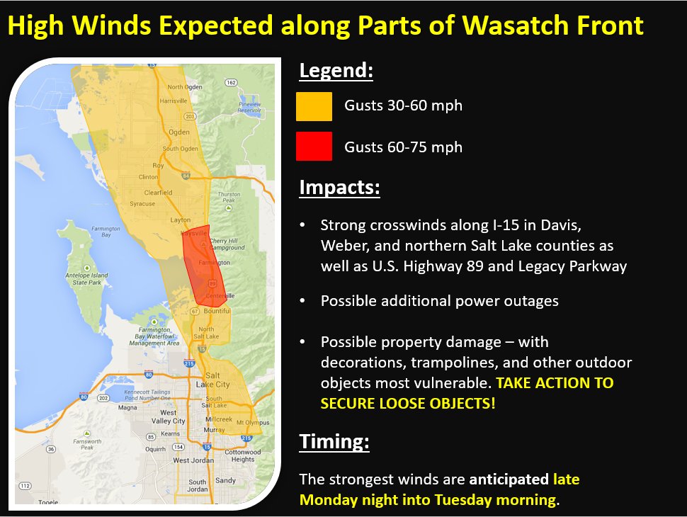
Secure your outdoor belongings now! Because high winds with gusts of up to 75 mph are heading to Utah as an Arctic storm system moves through late Monday night that could bring with property damage and power outages.
The downslope wind storm is expected to bring strong crosswinds along I-15 in Davis, Weber and northern Salt Lake counties. Crosswinds could also impact U.S. 89 and Legacy Parkway.
We have been mentioning the high winds and you may be familiar with the term "downslope winds". Attached our graphics where we expect the strongest winds to occur and an info graphic about downslope wind storms. pic.twitter.com/ZDXctlWuuT
— NWS Salt Lake City (@NWSSaltLakeCity) September 7, 2020
High winds should move in around midnight on Monday and continue through noon Tuesday, with a lull in the afternoon before winds pick up again Tuesday night into Wednesday morning.
Gusts of up to 75 mph could hit near Farmington, Centerville and the mouth of Weber Canyon. Salt Lake Valley could see 25-30 mph winds with gusts of up to 60 mph.
? WEATHER ALERT?
— NWS Salt Lake City (@NWSSaltLakeCity) September 7, 2020
We have multiple weather alerts in effect. Please visit our webpage at https://t.co/syF1KTUKUc for additional details. pic.twitter.com/CkqYSmk0A8
The Layton Fire Department issued a warning for residents to prepare for damaged structures, trees and power lines, and urged them to prepare their yards and home in advance.
STRONG winds expected throughout the night and early morning hours. Wind gusts likely to cause damage to structures, trees & power lines. Please prepare your yards and homes in advance! Now is a good time to review your family emergency plan! @LaytonFYI https://t.co/z9Zjl9aMZw
— LaytonFire (@Layton_Fire) September 7, 2020
Bountiful City also warned of strong winds and encouraged individuals to check the U.S. National Weather Service-Salt Lake City Facebook page for the latest information.
Strong winds tonight and tomorrow. Secure loose items on your property! Check out the US National Weather Service Salt Lake City Utah facebook page for the latest info. pic.twitter.com/Pv2vJDXHRe
— Bountiful City (@BountifulCityUT) September 7, 2020
Residents should secure all their outdoor belongings including trampolines, decorations and other items that could be knocked over by wind. Utah Highway Patrol also said that drivers with campers should be off the road by the time the windstorm moves in.
The NWS Situation Report notes that this storm is especially strong for this time of the year, and individuals should prepare for record colds.
Wind event tips: A thread
— Utah Division of Emergency Management (Utah DEM) (@UtahEmergency) September 8, 2020
If winds materialize like @NWSSaltLakeCity and other meteorologists are saying, Weber, Davis and Salt Lake residents could be in for a mess tonight.
Here’s what we leaned from a similar wind event in 2011.
1/ pic.twitter.com/3C8MW9t54u
The storm will bring a cold front and temperatures are expected to drop by around 26 degrees across Utah, with near-blizzard conditions across the Uintah Mountains and snow expected for the Wasatch Plateau and southwest Wyoming.
The cold front is on track. Tuesday will feel a lot different! Temperatures will be falling markedly from today's readings #utwx pic.twitter.com/eE26u7LnTW
— NWS Salt Lake City (@NWSSaltLakeCity) September 7, 2020
The National Weather Service confirmed that record-low temperatures are expected Tuesday through Wednesday with the wind and a hard freeze is expected for vegetation. Monday night through Wednesday, mountain rain and valley snow are forecast with strong probability, though some uncertainty remains on the precipitation type, amount, and duration. Rain is likely in all locations to start, including lower areas of western Colorado and possibly eastern Utah, the NWS’s Situation Report states. Snow is probable in areas above 9,000 feet, and may mix in at elevations of 7,000 feet.
Downslope windstorms occur when cold, dense air is pushed against a slope, creating an accelerating, and sometimes dangerous, wind at the bottom, opposite side of the slope. In Utah, the cold, dense air is on the east side of the Wasatch mountains, according to the NWS.
More information on KSL, Strange Sounds and Steve Quayle.


Wednesday September 9 2020, 10:57:10 UTC 112 km W of Panguna, Papua New Guinea 5.4 43.3 USGS Feed Detail
Wednesday September 9 2020, 10:57:10 UTC 5.4 43.3 USGS Feed
Wednesday September 9 2020, 14:28:14 UTC 171 km NE of Lospalos, Timor Leste 4.7 138.6 USGS Feed
Wednesday September 9 2020, 10:42:50 UTC 36 km NNW of Bandar Abbas, Iran 4.4 10.0 USGS Feed
Wednesday September 9 2020, 07:18:40 UTC 185 km SE of Sarangani, Philippines 5.8 18.0
Still don’t think it’s weather wars? We are flooding China and they are sending us cold and heat,and storms, plus multiple hurricanes,guess it beats being nuked.
M 3.9 – 2 km SW of Pitstone, United Kingdom places that do not get quakes will get quakes .
This is happening because of Full Moon SEP 2020 and now we will have OCT 1 and 31 Full moons in one month and Election is
NOV 3 2020 God Help us all. If Utah is getting sub zero weather
after extreme hot , both extreme cold weathers are signs of MEGA
Quake in progress!! I ask all of good people of USA please pray
pray for her peace in USA .
Mohsen BC