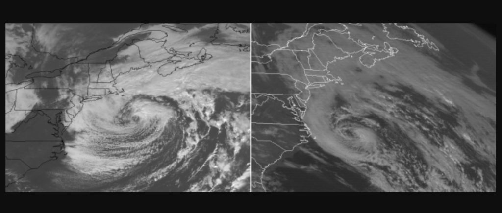
The nor’easter that pummeled areas from New Jersey to Maine, leaving hundreds of thousands without power, bears striking similarities to the 1991 ‘Perfect Storm,’ an infamous nor’easter that meteorologists still use as a benchmark storm 30 years later.
Side-by-side comparison of our current satellite view versus the Perfect Storm, which struck nearly 30 years ago today.
This one certainly lived up to the hype in eastern Massachusetts. #noreaster #bombcyclone pic.twitter.com/W9IMzn18vD
— Andrew Markowitz (@amarkowitzWX) October 27, 2021
The nor’easter could also transform into a tropical or subtropical system in the coming days, claiming the last designated name on the 2021 Atlantic hurricane season list.
The last bombogenesis in the US
The storm became the latest bomb cyclone to impact the United States, in the footsteps of two bomb cyclones that brewed over the eastern Pacific and slammed into the West Coast.
The storm that would later garner names such as the Halloween storm of 1991 and the ‘Perfect Storm’ for a Hollywood motion picture, took the lives of more than a dozen people. The greatest impacts on the U.S. were from heavy seas that caused considerable coastal flooding and beach erosion in New England and the mid-Atlantic.
Winds from this week’s nor’easter gusted over 100 mph, far above the readings from the 1991 storm, which maxed out at 76 mph.
However, AccuWeather.com Senior Weather Editor Jesse Ferrell pointed out, “There are hundreds of weather stations on the Massachusetts coast today compared to only a handful 30 years ago, so we can’t be sure this storm had higher winds. Because wind speeds can be local,” said Ferrell.
Complexity/intensity of the #noreaster #94L pic.twitter.com/GHsF3KTh3N
— Stu Ostro (@StuOstro) October 26, 2021
Meteorologists typically use pressure to gauge storm strength. By that measure, so far, this week’s nor’easter dropped to 28.76 inches of mercury (974 mb), slightly less powerful than the ‘Perfect Storm’ which measured 28.70 inches (972 mb) at its lowest reading.
After undergoing bombogenesis (a pressure drop of 0.71 of an inch of mercury in 24 hours) on Tuesday, the nor’easter is forecast to complete a counterclockwise loop near the southeastern coast of New England through Wednesday night.
This morning, water vapor imagery from the #GOESEast ?️ shows the strong #noreaster that continues to batter parts of the Northeast with heavy rain and high winds. It will gradually move away from the region by tonight. pic.twitter.com/DsCwK2WKx7
— NOAA Satellites (@NOAASatellites) October 27, 2021
Even though the heaviest rain is over from the nor’easter, the system remains a significant low-pressure area and is acting like a giant vacuum in the atmosphere. This will cause winds to rush toward the center and continue gusty conditions with the likelihood of additional falling trees and power outages, especially in southeastern New England and eastern Long Island, where the ground is saturated.
The surf will remain rough with significant beach erosion likely in the Northeast into Thursday. Offshore, heavy seas that are dangerous for small craft will continue through the end of the week.
IMPRESSIVE #GOESEast view of circulating #noreaster @OKwxlab pic.twitter.com/DZFuo97iuz
— Jacob Robb (@jacobrobbwx) October 27, 2021
Next hurricane?
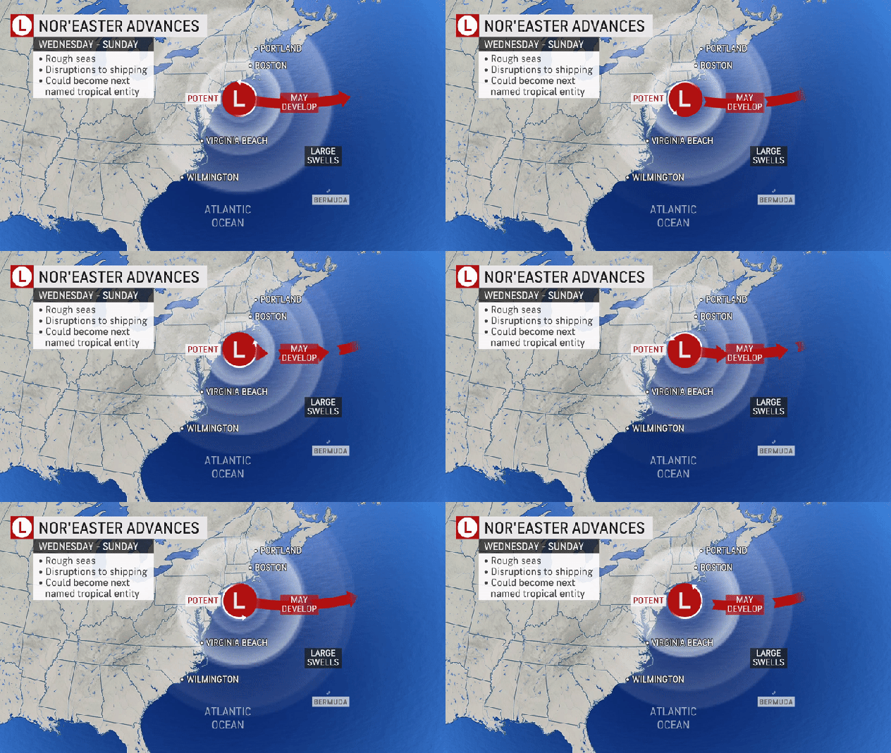
“Since the storm will spend a considerable amount of time over sufficiently warm Atlantic Ocean waters into the end of the week, there is the potential for the system to acquire tropical or subtropical characteristics,” AccuWeather Senior Meteorologist Bill Deger said. A subtropical system has both tropical and non-tropical storm features.

“In either case, there is a chance that the nor’easter could become a named storm as early as Thursday while taking an eastward path away from the U.S.,” Deger stated.
No significant impacts from the feature as a tropical or subtropical system are expected on the U.S. other than a continuation of rough surf and heavy seas well offshore. The most significant impacts would be to cross-Atlantic shipping, cruise and deep-sea fishing interests.
Temperatures in the waters a couple of hundred miles off the New England coast range from the upper 60s to the lower 70s F and are a bit too cool to nurture tropical development. Water temperatures near and above 78 degrees are generally the threshold.

However, several hundred miles offshore, water temperatures are higher. As the system turns eastward and treks over that warmer water, there could be some tropical development. The area where development may take place is somewhat detached from disruptive wind shear to the east.
Nor’easter to become a hurricane
No official names are given to non-tropical storms in the U.S., but toward the latter part of the lifecycle of the storm in late October and early November three decades ago, it became apparent that a tropical storm or hurricane had formed near the center of circulation. Despite this, no name was officially assigned to the storm by the National Hurricane Center.
The storm in 1991 had some piece of the tropics with it since it had absorbed Hurricane Grace, but the system churning just offshore in the Atlantic this week has no real tropical roots.
The next and final name on the pre-determined list of tropical storm names for the 2021 Atlantic hurricane season is Wanda.
There have been 20 named systems as of Wednesday, Oct. 27, of which one was a sub-tropical storm (Teresa), with seven hurricanes. Four of the systems strengthened into major hurricanes of Category 3 strength or greater.

The most intense tropical system of the season has been Category 4 Hurricane Sam with maximum sustained winds that reached 155 mph. Fortunately, Sam remained at sea while a tropical system from Sept. 22 to Oct. 5.
The second strongest hurricane of the season, Category 4 Hurricane Ida, produced maximum sustained winds of 150 mph and slammed into the Louisiana coast on Aug. 29. Ida was a deadly and destructive hurricane in the U.S. with 95 fatalities and damage estimates of at least $60 billion.
Should Wanda form, the 2021 Atlantic hurricane season will be solely in third place of the number of named systems, surpassing the 1930 season (20 named storms). Only the infamous 2005 season, which brought Katrina and 28 systems of tropical storm strength or greater, and the record 2020 season with 30 named systems had more. [Accuweather]
Now subscribe to this blog to get more amazing news curated just for you right in your inbox on a daily basis (here an example of our new newsletter).
You can also follow us on Facebook and/ or Twitter. And, by the way you can also make a donation through Paypal. Thank you!
You should really subscribe to QFiles. You will get very interesting information about strange events around the world.




Everything are under control of globalist and gangs of New World Order.NOV surprises is coming are you ready with food pantries? Wake up Dark Winter officially started with a chain of events California rain, Eastern states massive rain , snows etc… Taiwan war situations room. Iran war situations war room.Israelis will attack Iran sooner than later.Israelis 1.5 Billion dollars just for attack in Iran without contact? California and Northwest quakes mega quakes are ready and loaded to go?More Volcanoes are on the way.Political and social disunity will causes more harm to many nations. COVID 19 will soon become super
strength COVID man made by the vaccines? Right at your door!
Everything are under control of globalist and gangs of New World Order.NOV surprises is coming are you ready with food pantries? Wake up Dark Winter officially started with a chain of events California rain, Eastern states massive rain , snows etc… Taiwan war situations room. Iran war situations war room.Israelis will attack Iran sooner than later.Israelis 1.5 Billion dollars just for attack in Iran without contact? California and Northwest quakes mega quakes are ready and loaded to go?More Volcanos are on the way.Political and social disunity will causes more harm to many nations. COVID 19 will soon become super
stranth COVID man made by the vaccines? Right at your door!
I remember the last “perfect storm” 30 years ago. It had been a mild autumn, then they predicted 3 inches of snow would fall on Halloween night in the Midwest. By the time it ended we had over 3 feet. Everything in Minneapolis slowed to a crawl, roads impassable for days, which is rare for Minnesota. Record sub zero wind chills and weeks of misery for those who didn’t own a plow or a 4 wheel drive vehicle. We never imagined it could be a man made storm.
I remember we lost power for six days. Roads were impassable up in MN. Late 90’s. Icicles on the beardo type cold.
We always had snow by end of October. Jan/Feb were the fricken coldest months. Block heaters and ice scraper to windshield every day.
I hope it wipes out the entire east coast! Nothing but a bunch of idiot communists!
Well, I’ve seen videos lately where NY people are out protesting the vax baloney. So, they may be waking up. I hate communists too, but if they wake up and change their attitude, then I can be cool with them.
We all need to set aside our differences and attempt to unite against tyrants.