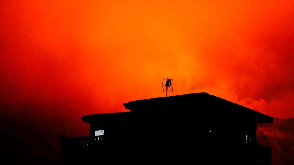
The La Palma volcano eruption is picking up again since December 1, 2021. The lava flow is affecting previously spared areas of the Spanish island, while an increase in tremors and emissions suggests the volcano is becoming more active.
Vídeo de la erupción a las 10.00 hora canaria desde Tacande. En la parte inferior se observa una de las coladas más recientes / Video of the eruption at 10.00 am Canarian time from Tacande. In the bottom part, one of the most recent lava flows can be observed pic.twitter.com/9cFrL1PcAj
— INVOLCAN (@involcan) December 2, 2021
With the opening of new vents (now 9) on Cumbre Vieja, a surge of fresh lava is rushing downhill towards the sea at speeds of up to 1 meter (3 feet) per second since Monday. The volcano shows now a strong strombolian activity:
Fuerte actividad estromboliana a las 18:25 hora canaria / Strong strombolian activity at 18:25 canarian time pic.twitter.com/a9Kj2i0dvo
— INVOLCAN (@involcan) December 1, 2021
While the activity of the main cone is currently slowing down, the second cone, that opened up last Thursday is spewing lava like never before!
? Otro video de anoche de la #erupción donde se aprecia la importante emisión de #piroclastos desde el cono secundario y las coladas de #lava que discurren hacia el noroeste grabado por personal del #IGNSpain.#ErupcionLaPalma #VolcandeLaPalma @mitmagob @CabLaPalma @RTVCes pic.twitter.com/i4EuoAmXh1
— IGN-CNIG (@IGNSpain) November 30, 2021
The volcano is not ‘sleeping’ anymore!
Imágenes tomadas desde la pista Cabeza de Vaca a las 13.30 hora canaria / Images taken from Cabeza de Vaca track at 1.30 pm Canarian time pic.twitter.com/2Jl4pBTMz0
— INVOLCAN (@involcan) December 1, 2021
The Puerto Naos area has been evacuated due to high levels of toxic gases emanating from the ongoing Cumbre Vieja volcano eruption.
➡️ Se evacúa a las personas que han accedido a la zona de Puerto Naos debido a altos niveles de gases en el lugar
➡️ Estas medidas pueden variar según la evolución de la emergencia. Es importante informarse a través de fuentes oficiales#MásFuertesQueElVolcán
— Cabildo de La Palma (@CabLaPalma) December 2, 2021
Copernicus estimates that the eruption has affected 1,163 hectares of surface and 2,790 buildings since its beginning on September 19, as shown in its latest map below:
#EMSR546 #ErupciónLaPalma #CumbreVieja
Our #RapidMappingTeam has released its 5⃣7⃣th updated map
It is based on 2⃣ @ASI_spazio COSMO-Skymed ? radar imagery
As of 1 Dec at 07:08 UTC:
➡️Extent of the lava flow?: 1,163.7 ha (+69 ha in 1 week)
➡️2,790 destroyed buildings?️(+95) pic.twitter.com/9lz969TNxU— Copernicus EMS (@CopernicusEMS) December 2, 2021
The island has recorded more than 374 earthquakes this Tuesday. That’s a new record. The previous maximum was set at 319 on November 17. Now, seismicity predominates at intermediate depths (between 10 and 15 kilometers).
#LaPalma https://t.co/I0ry4acxZE pic.twitter.com/7yqR88wvLN
— ?????? (@LetUsUniteHere) December 1, 2021
According to vulcanologists from IGN, the high seismicity will continue in the coming days. The earthquakes could also increase in intensity (>M5.0).
? Experimentando con el visor de terremotos, intentando meter algo más de información, pero sin saturarlo.
Está en desarrollo todavía, así que se agradecen aportaciones.
Actualizado con datos del catálogo de terremotos del @IGNSpain de hoy día 30 de noviembre por la mañana. pic.twitter.com/mD6XtDlEY8
— Pedro Suárez ? x-y.es (@x_y_es) November 30, 2021
Here some updated data on the ongoing eruption.
1. Main cone activity is scarce and intermittent, predominantly fumarolic activity.
2. Eruptive activity concentrated mainly on the northwest flank, where the accumulation of pyroclasts has led to the formation of a cone of pyroclasts with strombolian and effusive activity that emits lava flows that do not occupy new territory.
3. Small landslides occur inside the crater; Blocks are transported away by the lava flows.
4. Most of the energy flows through the north zone and the center zone of the old flows.
5. Meteorological conditions are favorable for operations of the La Palma airport.
6. Air quality is reasonably good in Los Llanos de Aridane and Tazacorte and good in the rest of the island.
7. Seismicity at intermediate depths has increased in the last 24 hours and has been located in the same areas. The number of earthquakes at depths greater than 20 km has also increased.
8. Latest data available on the affected area continues to be estimated at 1,163 hectares (29 hectares more than yesterday).
9. The southern lava delta is about 48.03 and the northern one is about 5.05.
10. The column height measured today has been 3,500 meters and the steam development cloud reaches 5,200 meters.
Meanwhile, a rainbow formed over Cumbre Vieja after a strong pyroclastic rain
Arcoíris sobre una lluvia de piroclastos en el volcán de #LaPalma.
El fenómeno óptico se ha podido observar junto el cráter de #CumbreVieja, como muestran estas imágenes grabadas hoy (01/12/2021) por el biólogo Manuel Nogales, del @IPNA_CSIC pic.twitter.com/XU1OnGgJCm— CSIC (@CSIC) December 1, 2021
Now subscribe to this blog to get more amazing news curated just for you right in your inbox on a daily basis (here an example of our new newsletter).
You can also follow us on Facebook and/ or Twitter. And, by the way you can also make a donation through Paypal. Thank you!
You should really subscribe to QFiles. You will get very interesting information about strange events around the world.


That strobolian activity seems powerful. More earthquakes at shallow depths too. Those people living there must have big balls. I would be fishing, and making sashimi on deck, way out in the water. Far away.
It’s actually bad that they aren’t evacuating the towns nearby or are they hoping to let a bunch die off? Free land afterwards…
Question – is there any land deformation on the SW slope???
Ha, I was wondering the same.