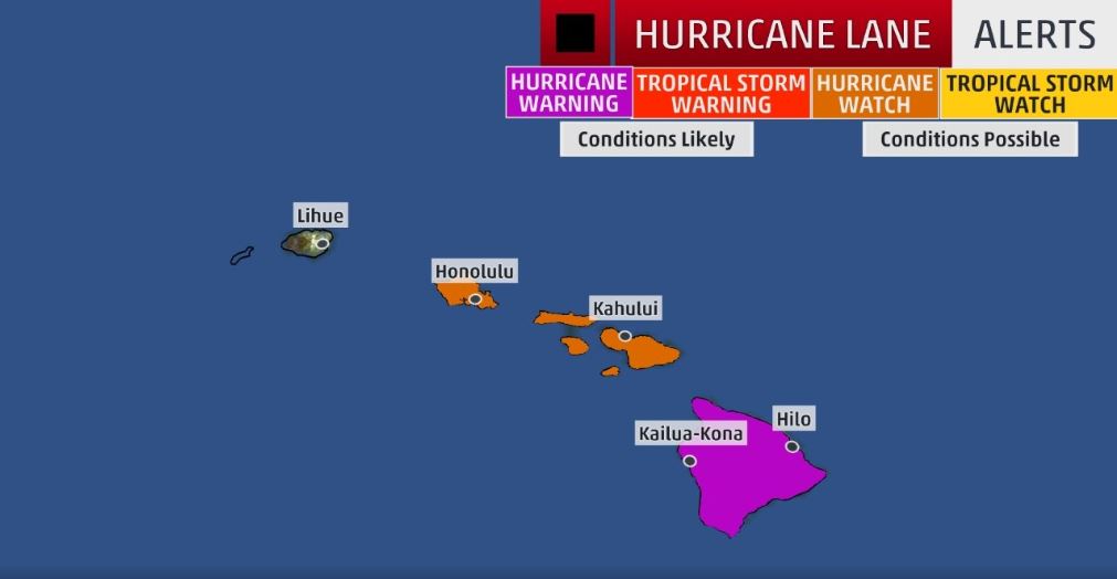
A very powerful and dangerous storm, Category 5 Hurricane Lane, is dangerously approaching Hawaii’s Islands. Situated several hundred miles southeast of Hawaii, Hurricane warnings have been issued for Hawaii County and Hurricane watches are in effect for Maui County and Oahu. Lane will curl northwestward starting Thursday toward Hawaii, eventually weakening. Whether the core of Lane’s strongest winds affects parts of the islands Thursday-Saturday remains uncertain. Regardless, flash flooding, mudslides, battering waves and coastal flooding are likely.

Hurricane Lane strengthened to Category 5 intensity and, while forecast to weaken, poses a danger to Hawaii Thursday through Saturday with flooding rain, battering surf, coastal flooding and high winds possible.
A hurricane warning is in effect for the Big Island of Hawaii, meaning that hurricane conditions are expected within the warning area.
A hurricane watch is in effect for Maui and Honolulu Counties, including the islands of Maui, Lanai, Molokai, and Kahoolawe and the city of Honolulu. This means hurricane conditions are possible within the watch area, and is typically issued 48 hours before the onset of tropical storm-force winds that may make preparations difficult or dangerous.
Current Status and Forecast Track Uncertainty
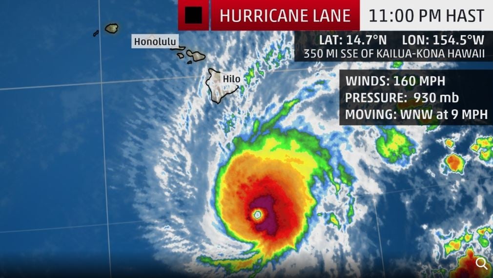
The center of Lane is about 350 miles south-southeast of the Big Island’s Kona coast or about 500 miles south-southeast of Honolulu, Hawaii, moving west-northwest. Lane is now an immensely powerful Category 5 hurricane with 160 mph winds.

Hurricane Lane joined an exclusive company of Central Pacific Category 5 hurricanes, the first since Ioke in 2006, only the second on record within 350 miles of Hawaii (John in 1994 was the other) and the most intense north Pacific hurricane east of the International Date Line since Patricia in 2015.
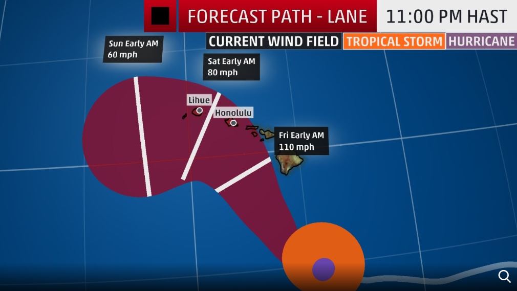
The forecast track and intensity of Lane remains quite uncertain, and small changes to its track and intensity are important for some potential impacts in the Hawaiian Islands. Lane will begin to curl northwest Wednesday, reaching the edge of subtropical high pressure which had been steering it. Lane is then forecast to eventually turn back to the west sometime Friday into Saturday. The key for some impacts is when those two turns occur and how sharp those turns are, which will determine how close the core of Lane’s strongest winds come to the islands.
If Lane moves along the southern or western portion (left side) of its forecast projected path, it would be far enough from the islands to avoid the worst wind impacts of its core, but still produce peripheral impacts: heavy rainfall, windy conditions, dangerous surf and rip currents.

If, however, Lane turns sharp enough northwest or even north along the northern or eastern side (right side) of its forecast projected path, damaging winds from the hurricane’s core could swipe parts of the islands, in addition to torrential rain from the core and more damaging coastal flooding from both the setup of battering waves and water rise for those areas prone to water rise.
Hawaii: Today is the day to get ready for #HurricaneLane. Take these simple steps:
? Check your emergency kit and restock it.
? Review evacuation guidance for your area.
? Keep the gas tank filled in your car.— FEMA (@fema) August 21, 2018
Further complicating this, as noted by the University of North Carolina – Charlotte graduate student Eric Webb, was the potential of Lane’s wind field to interact with the terrain of the Big Island.
While waters should be sufficiently warm, wind shear is expected to increase by Thursday, triggering a weakening of Lane. Despite that, Lane could still be a formidably strong hurricane near or off the Kona Coast of the Big Island Thursday, and may still be at hurricane strength near or off the coast of Maui County or Oahu Friday, areas that are not accustomed to hurricane conditions.
Perhaps the most dangerous impact from Lane won’t depend as much on its intensity or exact track, but rather may result from its slowing forward speed, in the form of heavy rainfall, as we’ll detail in our impacts section below. Residents in Hawaii, particularly in watch and warning areas should complete storm preparations, including putting together an emergency kit and a family emergency plan. Those with vacation plans to Hawaii through Saturday should consider changing their plans.
Rainfall Flood Threat
Regardless of the exact track, bands of heavy rain are likely to affect many, if not all, of the Hawaiian Islands. These heavy rainbands may persist for a time after the closest approach of the center of Lane. Moist winds up the slopes of the 10,000+ foot peaks of Maui and the Big Island on Lane’s eastern flank could lead to prolific rainfall, potentially unleashing deadly flash flooding and landslides.

Heavy rain and flash flooding are also threats on Oahu and Kauai, particularly Friday into Saturday. According to the CPHC, isolated maximum rainfall totals of more than 20 inches are possible, particularly over south and/or east-facing slopes.
High Wind Threat
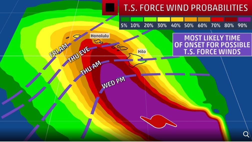
At least tropical storm-force winds (39 to 73 mph) are increasingly likely in all of the islands. These tropical storm-force winds may begin as soon as Wednesday night in the Big Island, Thursday in Maui County, Thursday night in Oahu, and Friday in Kauai. There is a small chance of hurricane-force winds (74 mph or higher) in parts of the islands, particluarly along the western or southern coasts.

As stated earlier, small changes in the track forecast will make the difference between the core of Lane’s strongest winds affecting at least parts of the islands, or remaining offshore. Regardless, the combination of heavy rain and strong winds could down more trees than strong winds alone.
High Surf/Coastal Flood/Storm Surge Threats
Swells are now building along especially the south and east-facing coasts of the Big Island. These swells will spread across the rest of the Hawaiian chain beginning Wednesday. Dangerous surf conditions and rip currents are expected, especially on exposed west, south and east-facing coasts, including those typically not accustomed to large waves, such as Waikiki Beach, Maui and the Kona Coast. The surf could be damaging in spots. Coastal flooding, possibly storm surge flooding if the core of Lane moves close, is also expected, but depends on the exact track of Lane.
Hawaiian Hurricane History
According to NOAA’s best track database, there is no record of a hurricane track within 65 nautical miles of either Maui or Honolulu since statehood. There have been three notable hurricanes that struck the western island of Kauai during that time: landfalls of Iniki in 1992 and Dot in 1959 and an eyewall brush with Iwa in 1982.
Three of the previous Category 5 central Pacific hurricanes occurred in 1994 during a hurricane season that featured a central Pacific flavor of El Niño called modoki El Niño. Modoki El Niño’s occur when the warmest pool of water compared to average occurs in the central Pacific rather than in the eastern Pacific.
Be ready, stockpile to get in Lane!
Follow us: Facebook and Twitter
Weather – Category 5 Hurricane Lane Prompts Hurricane Warning for Hawaii’s Big Island, Watches For Maui, Oahu, Including Honolulu
Daily Mail – Hawaiians rush to stock up on supplies ‘food, bottled water and toilet paper’ in anticipation for ‘Hurricane Lane’ that could hit the Islands by Wednesday


[…] Hurricane Lane Alert: Rare Hurricane Warning for Hawaii’s Big Island and Hurricane Watch Issue… […]
[…] to gain unauthorized access to computers and networks – and stolen information they’ve found. Hurricane Lane Alert: Rare Hurricane Warning for Hawaii’s Big Island and Hurricane Watch Issued fo… Germany Calls For Global Payment System Independent Of The US How the Banks Will Steal Your Money […]
One of the best and informative reports I have seen.
END TIMES SIGNS LATEST STRANGE EVENTS (AUG 22, 2018) THIS HAPPENED ON OUR EARTH | EXTREME WEATHER
https://www.youtube.com/watch?v=hxbBxVZzqC4
Videos compilados del terremoto ocurrido en Venezuela, Trinidad y Tobago y Granada, de 7.3 grados Richter
https://www.youtube.com/watch?v=zwsJkjOnLBE
Because of this earthquake, Tower of David partially collapsed, and leaned 25 degree.
https://en.wikipedia.org/wiki/Centro_Financiero_Confinanzas
“On 21 August 2018, the tower was significantly damaged by an earthquake which caused the partial collapse of the top five floors, resulting with the affected portion leaning outward by 25 degrees”
This cleansing earthquake almost got rid of satanic skyscraper.
Las ruinas de Caracas: La torre de David
https://www.youtube.com/watch?v=dbWto_GWTmI
10 people killed after flash flood hits Raganello gorge in southern Italy’s Calabria
https://watchers.news/2018/08/21/10-people-killed-after-flash-flood-hits-raganello-gorge-in-southern-italy-s-calabria/
This was the popular canyon for canyoning (hiking, climbing, swimming along a canyon). In that day, there are so many people canyoning in that gorge. Usually canyoning is operated by guiding tours, but some people goes solo. They do not know how many people were in the gorge at that flash flood time.
This is the cleansing flash flood washed away all the privileged reptilians who have money and time in that gorge. Reptilians have plenty of money because they have the agreement with any government on the Earth in order to create money as much as they want. They do not need to work, of course, so they have plenty of time to enjoy their life and play around mountains, canyons, lakes and beaches. They love to visit many places with the money they created out of thin air. They usually stay in luxurious resorts or expensive restaurants. They create FREE money putting any number they want into their bank account in order to enslave humans who work 8 hours at least per day. The work or job are the only for slave grade humans who serve for reptilian entities.
This incident remind me another incident in Page, Arizona. A dozen of reptilian youths were enjoying the tour of Antelope Canyon where they had a surprise flash flood. Why was a surprise flash flood? Because no body expected they get flash flood. But many miles away, they had quite amount of rain, and Antelope Canyon collected all that water from upper side of mountain. All reptilian youth died except a guide. I tell you that reptilians following evil agenda of Reptilian entities cannot escape their demise wherever they go.
Sole survivor of Antelope Canyon flash flood describes horrific tragedy 20 years later
http://www.azfamily.com/story/36003725/sole-survivor-of-antelope-canyon-flash-flood-describes-horrific-tragedy-20-years-later
Five miles upstream, a downpour caused a 30 foot wall of water to crash down on the canyon. “And then I saw this tail of water, like off of a jet ski, shoot off about 10 feet in the air, and I went ‘oh my God it’s water.’ You have no idea the force that is behind something like that.” Quintana watched as several of the hikers were swept away. “The water came, and bodies started flying down. The first couple were like rag dolls, flopping down through the canyon.” Then several more were pulled by the torrent.
Those perished young tourists came from France, Germany and England. Basically reptilians do not have borders. They can travel freely in any country. Borders are in order to control human population in each country just like sheep need border fence to be controlled. Reptilians treat humans just like sheep. We are their cattle.
Made by the man …
[…] post Hurricane Lane Alert: Rare Hurricane Warning for Hawaii’s Big Island and Hurricane Watch Issue… appeared first on STRANGE SOUNDS – AMAZING, WEIRD AND ODD […]