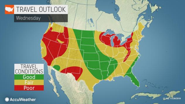
Dangerous travel conditions are being reported across portions of the western U.S. on the busiest travel day of the year.
And the detrimental impacts from snow, rain and gusty winds are set to continue into Thanksgiving Day.
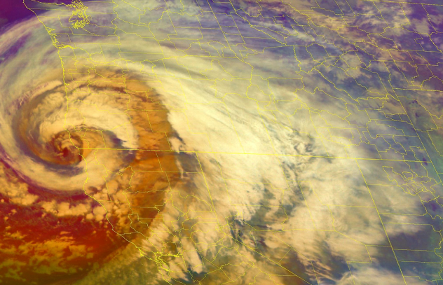
Since Monday night, the barometric pressure of the storm system itself went from 1,018 millibars (mb) to 970 mb Tuesday evening. This 48 mb drop in 24 hours doubles the requirement of a 24-mb drop in 24 hours – the National Weather Service’s (NWS) threshold for an official “bomb cyclone.”
The OR/CA storm peaked pressure-wise with a central pressure of 970 hPa/28.64″ at 7 pm PST before slowly weakening. Here are its impacts thus far: pic.twitter.com/U4uHH0CBVW
— NWS WPC (@NWSWPC) November 27, 2019
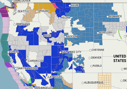
Weather watches, warnings and alerts peppered the western half of the nation as the potent storm, also known as a “bomb cyclone,” began to make its impacts felt on Tuesday.
Watch this low pressure system rapidly strengthen as it approaches the US west coast in this 17-hour GOES-17 Airmass RGB animation (all images generated via Python). #ORwx #BombCyclone pic.twitter.com/tnCbWwUBMr
— Kim Wood (@DrKimWood) November 26, 2019
The storm could be historic in its strength and scope and so far that has been the case.
As the storm system came ashore Tuesday night in southern Oregon and Northern California, an all-time record low sea level pressure in the state of California had been surpassed. Crescent City, California, has now surpassed the storm system that set the previous record back in 2010.
A dangerous storm is heading towards southwest Oregon and northwest California Tuesday and Wednesday, in the run up to Thanksgiving. Prepare now for possible impacts. pic.twitter.com/XtYz36JLql
— NWS WPC (@NWSWPC) November 25, 2019
On late Tuesday afternoon, Interstate 5 was closed to trucks north of Redding, California, due to bad weather conditions.
Interstate 5 is closed to trucks north of Redding. For the latest road conditions across interior NorCal call CALTRANS at 1-800-427-7623. #cawx
— NWS Sacramento (@NWSSacramento) November 26, 2019
The California Department of Forestry and Fire Protection (Cal Fire) responded to numerous vehicles accidents along the Interstate 80 corridor Tuesday night where treacherous travel was reported along Donner Summit. Severe people were taken to a nearby hospital as a result.
The system came on the heels of an early-week storm, which brought heavy snow to the Denver area and wind gusts of 70-80 mph to the Los Angeles area on Monday night, according to the NWS, set the stage across much of the West, allowing for a winterlike chill to be entrenched across the Northwest and into much of California and Nevada. This included a small thunderstorm that dropped hail across part of the Seattle area.
Winds have settled down for the most part, but some gusty winds were still hanging on in the mtns. In some isolated locations, gusts reached 70-80 mph! Check out the latest wind reports from the last 6 hours: https://t.co/lYdy9SVRCT #SoCal #CAwx #LAwind #SBAwind
— NWS Los Angeles (@NWSLosAngeles) November 26, 2019
Heavy Rains
The wet weather, combined with gusty winds across the state will cause travel concerns for much of the region on Wednesday and Thursday.
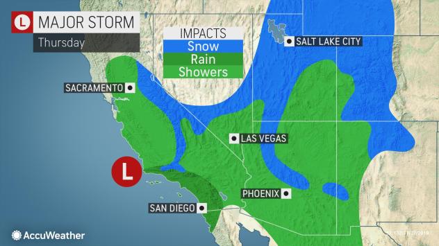
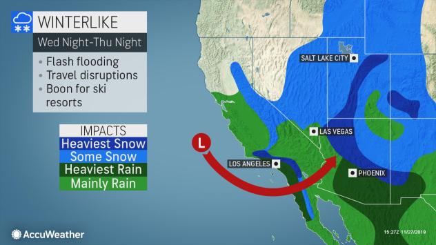
This storm threatens to bring rain and mountain snow to much of California, including places like San Francisco and Sacramento, places that were largely spared by the past week’s rain.
While burn scar areas may experience flooding and mudslides, travel woes are anticipated with the rounds of heavy rain expected as the storm system brings rain and snow into Southern California.
Slick roadways will be a concern for motorists in places like Santa Barbara, Los Angeles and San Diego from Tuesday night through Thursday night.
Flash flood watches were in effect for parts of Southern California Wednesday morning, including San Diego and San Bernardino.
Driving in the Columbia River Gorge as a bomb cyclone churns off the coast. I’ve never seen the waterfalls being blown away quite like this! ?#oregon #BombCyclone @NWSPortland pic.twitter.com/FU8jTfLjHl
— Rachel Pross (@prossibility) November 26, 2019
More than 55 million travelers are expected between the weekends before and after Thanksgiving, according to the American Automobile Association (AAA).
San Francisco’s worst travel time is expected between 2 p.m. and 4 p.m. on Wednesday, by which time the city’s heaviest rain is expected to be over. However, for Los Angeles, the estimated timeframe for most travelers is 5 p.m. to 7 p.m. on Wednesday, when periods of rain are expected to continue.
Cold Temperatures and Snow Accumulation
In addition to the impacts the rain will have on the region, the cold coming in with this storm will allow for high snowfall accumulations that can contribute to the travel disruptions.
Bomb cyclone causes Thanksgiving travel chaos for millions https://t.co/X0VoiL4LGh via @MailOnline
— Nicky (@LovelyNicky247) November 27, 2019
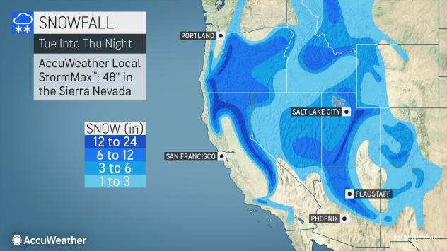
With snow levels, down to around 4,000 feet, feet of snow will pile up in the Sierra Nevada of California. Some parts of the Sierra Nevada mountains could see up to 42 inches of snowfall. Snow will even reach as far south as the Peninsular Mountains in Southern California.
Along Interstate 5, just north of the border between California and Oregon, over Siskiyou Summit, slippery conditions are expected for travelers through Wednesday night.
Donner Pass, along Interstate 80, has already begun to receive heavy snow, leading to travel delays. A foot or more of snow is forecast from the storm.
Farther south, snow will dip down to the passes north and northeast of Los Angeles into Wednesday night.
100s of drivers left stranded near Oregon-California border for 17 HOURS in blizzard, while large swathes of US are paralyzed by ‘bomb cyclone’ & up to 30 inches of snow – canceling flights as 55 million set off for Thanksgiving- pic.twitter.com/LUZml9uhci
— Blanche V. Mercaldi (@tammytabby) November 27, 2019
Outside of California, snow will spread across Oregon into Nevada, Idaho and Utah. Snowfall accumulations will very much depend on elevation in these areas, although some of the highest snowfall totals could be in southwestern and northern Utah.
Winter storm watches and warnings have been issued for many of the mountains across the region ahead of the storm’s arrival.
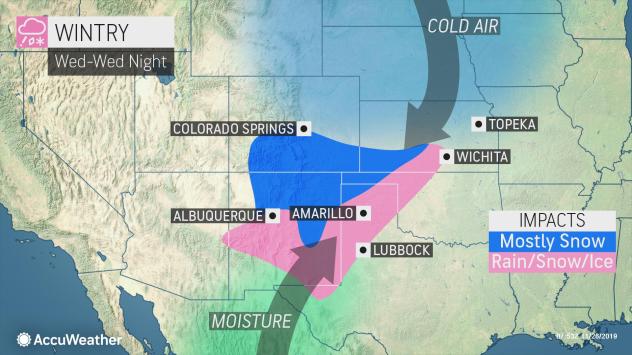
Snow will also stretch into Arizona, starting in northwestern parts of the state late Wednesday night, then spreading across the northern two-thirds of the state into Friday.
Just a little more than 6.5 inches of snow fell in Flagstaff with the last storm that moved through the region, with another dose of snow likely for the middle and end of the week. The higher terrain around the region could have a fresh foot of snow before the end of the month.
Hundreds stranded on Interstate 5 in ‘bomb cyclone’ fallout https://t.co/6swWU45tQk pic.twitter.com/f1UVCvl51X
— The Press Democrat (@NorthBayNews) November 27, 2019
Snow showers across Arizona, Utah and western Colorado may linger as late as Friday morning, continuing to add to any snowfall totals.
So if you are on the road just be very careful. This double bomb cyclone is going to be a hell of a storm! [Accuweather]


 in 3 days of storm")


This is proof positive of global climate change due to the over-emission of CO2 into the atmosphere.
Al Gore was right but everyone laughed at him. Very few took the facts he proved and believed the truth.
Now it will get worse as global climate change destroys the world unless all CO2 emissions are extremely reduced immediately and anyone still polluting is paying a carbon tax as the price for cleaning up after their mess.
If after all of this anyone still doubts climate change due to CO2 emissions then they are a fool and should be sent to a school that forces them to understand the facts of science, which in the case of global climate change and as this latest of many storms proves, is real.
Blaming it on “engineering” is to suppress the truth about climate change due to CO2 using propaganda originating from the oil and coal industries similar to how tobacco companies suppressed the truth about their products and the proven deadly danger second hand smoke was until finally the truth was accepted and the lies no longer believed.
I have lived in Denver for 34 years and not one time throughout all those years has it snowed 33 inches. We had not even one foot (12”) of snow. This is all exaggerated drama to create division in the population as to whether or not global warming is real and to continue climate ENGINEERING. all the made up names for storms and double bomb cyclones? Yeah that’s the disinformation power structure trying to cover the tracks from ionosphere heaters throughout the world manipulating atmospheric pressure. This is not natural in any way. Please research chemical ice nucleation and engineering winter at http://www.geoengineeringwatch.org
You are correct ,geoengineeringwatch.com shows the facts of weather manipulation mixed with the solar minimum. All to cause division and famine,which they will use against the American people.
Right you are Jay!l The Sheeple are too dumb to know what’s happening to them. I told my wife when they launched the so called weather satellite over the Pacific area, that it was a weather making satellite and not a weather observing one. I also said to watch for big strange storms coming from that area,and here they are.